This item has been sold, but you can get on the Waitlist to be notified if another example becomes available, or purchase a digital scan.
1854 Mitchell Comparative Chart of the World's Mountains and Rivers
RiversMountains-mitchell-1854$92.50

Title
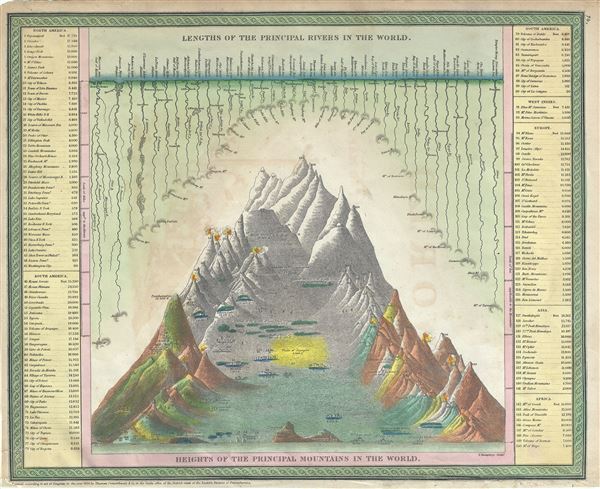
Lengths of the Principal Rivers in the World. / Heights of the Principal Mountains in the World.
1850 (dated) 13 x 16 in (33.02 x 40.64 cm)
1850 (dated) 13 x 16 in (33.02 x 40.64 cm)
Description
This is an attractive example of Mitchells 1854 Comparative Mountains and Rivers Charts. Mitchell based his Mountains and Rivers Chart on a nearly identical map first prepared by the American engraver H. S. Tanner in 1836. This stunning center weighted chart, built on the Finley model, makes the significant advance of incorporating both mountains and rivers with substantial scientific and statistical data. The problem with both this map and Finley's is that the center weighted style fails to express context on a local level, thus diminish the magnitude of smaller yet highly significant ranges (like the Andes or the Alps) in comparison to the majesty of the Himalayas.
Mitchell published this chart in his atlas from 1846 to the late 1850s before discontinuing the series and selling his map plates to DeSilver. This map was prepared by S. A. Mitchell for publication by the Philadelphia firm of Thomas Cowperthwait and Co. as plate no. 74 in the 1854 edition of Mitchell's New General Atlas. Dated and copyrighted, 'entered according to act of Congress in the year 1850 by Thomas Cowperthwait and Co. in the Clerk's office of the eastern District of Pennsylvania.'
Mitchell published this chart in his atlas from 1846 to the late 1850s before discontinuing the series and selling his map plates to DeSilver. This map was prepared by S. A. Mitchell for publication by the Philadelphia firm of Thomas Cowperthwait and Co. as plate no. 74 in the 1854 edition of Mitchell's New General Atlas. Dated and copyrighted, 'entered according to act of Congress in the year 1850 by Thomas Cowperthwait and Co. in the Clerk's office of the eastern District of Pennsylvania.'
Cartographer
Samuel Augustus Mitchell (March 20, 1792 - December 20, 1868) began his map publishing career in the early 1830s. Mitchell was born in Bristol, Connecticut. He relocated to Philadelphia in 1821. Having worked as a school teacher and a geographical writer, Mitchell was frustrated with the low quality and inaccuracy of school texts of the period. His first maps were an attempt to rectify this problem. In the next 20 years Mitchell would become the most prominent American map publisher of the mid-19th century. Mitchell worked with prominent engravers J. H. Young, H. S. Tanner, and H. N. Burroughs before attaining the full copyright on his maps in 1847. In 1849 Mitchell either partnered with or sold his plates to Thomas, Cowperthwait and Company who continued to publish the Mitchell's Universal Atlas. By about 1856 most of the Mitchell plates and copyrights were acquired by Charles Desilver who continued to publish the maps, many with modified borders and color schemes, until Mitchell's son, Samuel Augustus Mitchell Junior, entered the picture. In 1859, S.A. Mitchell Jr. purchased most of the plates back from Desilver and introduced his own floral motif border. From 1860 on, he published his own editions of the New General Atlas. The younger Mitchell became as prominent as his father, publishing maps and atlases until 1887, when most of the copyrights were again sold and the Mitchell firm closed its doors for the final time. More by this mapmaker...
Source
Mitchell, S. A., A New Universal Atlas Containing Maps of the various Empires, Kingdoms, States and Republics Of The World, (Thomas Cowperthwait & Co., Philadelphia) 1854.
Condition
Very good. Minor overall toning and offsetting. Minor spotting. Verso repair near left border.
References
Rumsey 3803.002 (1853 edition). Phillips (Atlases) 809.