This item has been sold, but you can get on the Waitlist to be notified if another example becomes available, or purchase a digital scan.
1944 Chapin Map of Eastern Europe and the Red Army Advance
RoadstoWarsaw-chapin-1944$250.00

Title
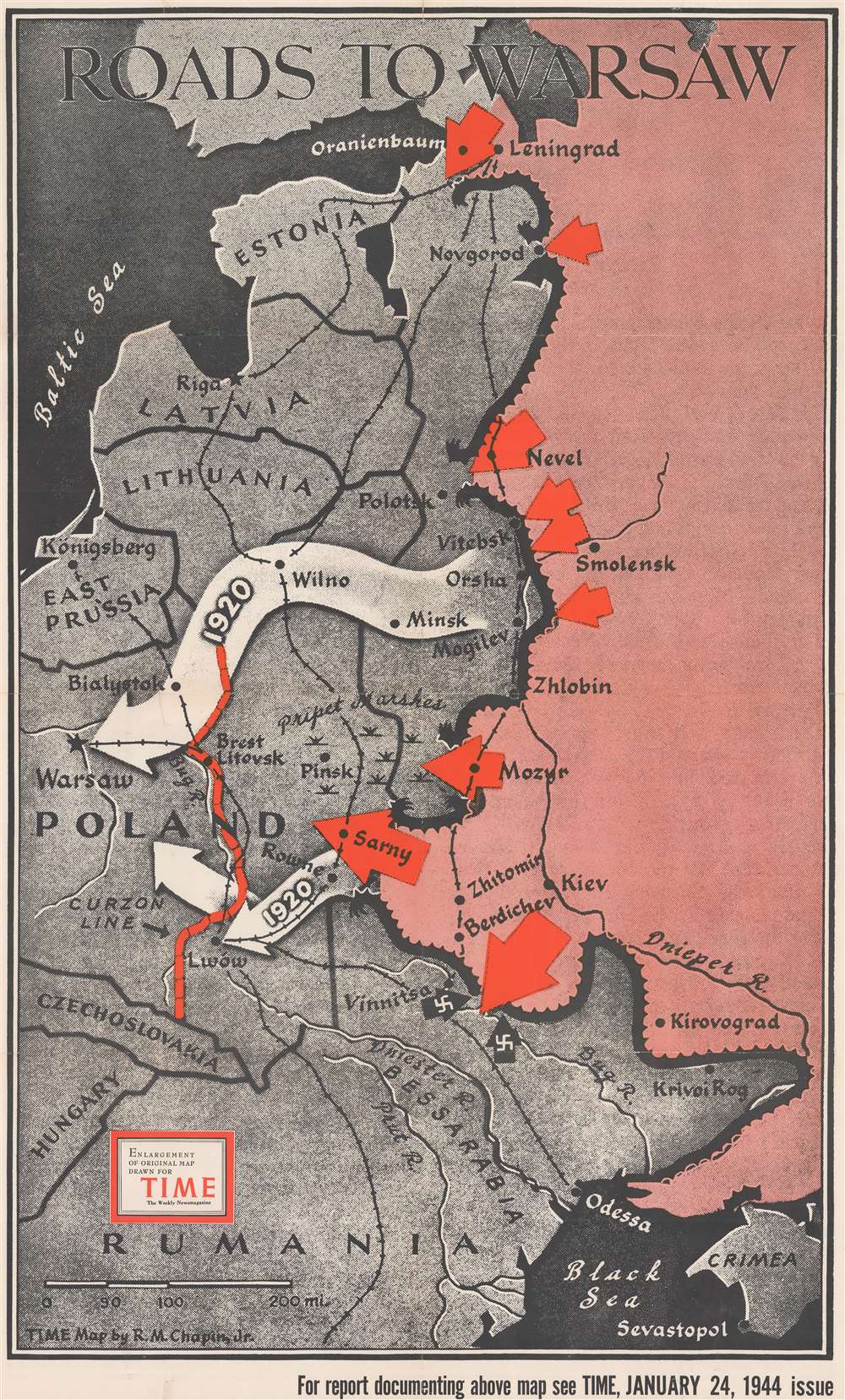
Roads to Warsaw.
1944 (dated) 42.25 x 25.5 in (107.315 x 64.77 cm) 1 : 1689600
1944 (dated) 42.25 x 25.5 in (107.315 x 64.77 cm) 1 : 1689600
Description
This is a separately issued large format 1944 Robert M. Chapin Jr. map of eastern Europe and Russia illustrating the Soviet Red Army's advance. Large red arrows highlight combat areas. The largest arrows at Sarny, Vinnitsa, and Mozyr highlight important Soviet successes in breaking through the German lines. At the time of publication, a massive battle was underway at Vitebsk and the army near Mozyr was pushing through the Pripet Marshes toward Pinsk. The army at Sarny had just cut an important north-south rail line and was quickly advancing on the Lwow-Konigsberg rail line. The large white arrows reference the Red Army's 1920 march on Warsaw, when they reached the city but failed to defeat the Polish army.
Publication History and Census
This map was drawn by Robert M. Chapin Jr. to accompany an article published in the January 24, 1944 issue of TIME. It also bears a collection stamp from the Ashtabula Public Library in Ohio on verso. We have contacted the library and confirmed that it was legally deaccessioned. We note two examples cataloged in OCLC as part of the collections at Franklin and Marshall College and Wichita State University.Cartographer
Robert M. Chapin Jr. (fl. 1933 - 1970) was a prominent architect, cartographer and illustrator active during World War II and the Cold War. Chapin graduated from the University of Pennsylvania in 1933 with a degree in architecture. Since this was the height of the Great Depression, and architects in low demand, he instead took work as a staff cartographer at Newsweek. Catching the attention of Manfred Gottfried of Time, Chapin was offered an accepted a position at the head of Time's cartography department. He remained with Time for some 33 years, from 1937 to 1970, often drawn 2 - 3 new thematic maps weekly. With an architect's gift visualizing information, Chapin became a skilled informational cartographer, heading the cartography department at Time Magazine. Chapin, like Fortune Magazine chief cartographer, Richard Edes Harrison, Chapin was at the forefront of infographic propaganda cartography, a genre that matured during the World War II Era and remains popular today. Working for Time Magazine, Chapin developed a signature style for his long run of 'War Maps.' Chapin was known for his maverick airbrush technique which lead to strong color splashes and intense shading. He also incorporated celluloid stencils to illustrate bomb explosions, flags, sinking ships, and more - generating a instantly recognizable standardized style. Chapin's Time war maps were further distinctive for their use of strong bold reds as a universal symbol of hostility. Chapin graduated from the University of Pennsylvania in 1933 with a degree in architecture. Since this was the height of the Great Depression, an d architects in low demand, he instead took work as a staff cartographer at Newsweek. Catching the attention of Manfred Gottfried of Time, Chapin was offered an accepted a position at the head of Time's cartography department. He remained with Time for some 33 years, from 1937 to 1970, often drawn 2 - 3 new thematic maps weekly. Chapin live in Sharon Connecticut. More by this mapmaker...
Condition
Good. Verso repairs to fold separations. Verso fold reinforcements. Two closed two inch tears extending vertically from central fold professionally repaired on verso. Closed one inch tear extending from bottom edge professionally repaired on verso. Exhibits a couple small areas of infill.
References
OCLC 47829083.