1983 World Peace Council Comic Map of the 'World According to Ronald Reagan'
RonaldReagan-worldpeace-1983$700.00

Title
The World According to Ronald Reagan.
1983 (undated) 19.75 x 27.5 in (50.165 x 69.85 cm)
1983 (undated) 19.75 x 27.5 in (50.165 x 69.85 cm)
Description
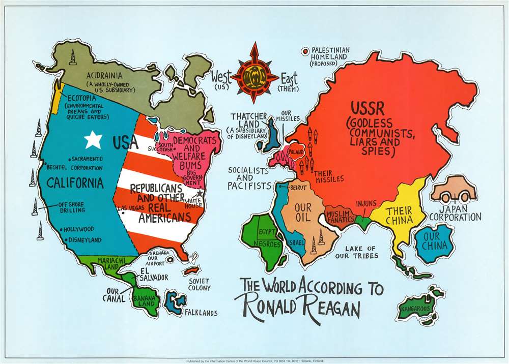
An amusing piece of late Cold War propaganda, this c. 1983 World Peace Council propaganda map of the world presents the world from U.S. President Ronald Reagan's point of view.
The United States and the Soviet Union
The United States and the Soviet Union dominate the world in a literal fashion, as both are depicted much larger than they are in reality. The U.S. is divided into four sections: 'Democrats and Welfare Bums' in the Northeast, 'Republicans and other Real Americans' in the Midwest and Southeast, 'California' dominates the west, and 'Ecotopia' (home to environmental freaks and quiche eaters) occupies a sliver of the Pacific Northwest. Four places are marked in California, which are Sacramento (where Reagan worked as governor), the Bechtel Corporation, Hollywood (where Reagan worked as an actor), and Disneyland. Both the White House and Las Vegas appear in the 'Republicans and Real Americans' region, while 'Democrats and Welfare Bums' is home to 'Big Government'. The USSR, however, is said to be the land of 'Godless Communists, Liars and Spies'.The Rest of the world and 'Us' vs. 'Them'
The map's main theme is to divide the world into an 'us' vs. 'them' duality. For example, 'Their China' and 'Our China' are differentiated, and the Aragian Peninsula is labeled as 'Our Oil'. The Panama Canal is identified simply as 'Our Canal', even though the canal was being jointly administered by the U.S. and Panama by the early 1980s and would be handed over to Panama in 1999. Europe is practically nonexistent and appears only as a place for 'Our Missiles' just across the border from 'Their Missiles. Even American allies that appear on the map are not rendered politely. Canada is labeled as 'Acidrainia (A Wholly-Owned US subsidiary)', Mexico is labeled 'Mariachi Land', the entirety of South America bears the label 'Banana Land', and Australia is marked simply as 'Kangaroos'. Japan is illustrated in the shape of a car and marked as 'Japan Corporation'. Even England, purportedly America's closest ally, is known only as 'Thatcher Land (A Subsidiary of Disneyland)'.The World Peace Council
The Soviet Union established the World Peace Council in 1950 as an organ to promote its foreign policy. Along with other front organization, the World Peace Council and its members promulgated the dichotomy between the 'peace-loving' Soviet Union and the 'warmongering' United States. It was largely funded by the Soviet Union and based in Helsinki from 1968 to 1999, when it moved to Athens, Greece. During the Cold War, the World Peace Council's main activity was organizing international conferences. Attended by thousands, these conferences condemned western military aggression, armaments, and weapons tests. Ironically, they never criticized Soviet aggression. In 1956, for example, the World Peace Council condemned the Suez Crises (1956 - 1957) but said nothing about the Soviet invasion of Hungary (1956). Other blatant examples include rationalizing the Soviet Union's unilateral resumption of atmospheric nuclear testing in 1961 and its explanation of the 1979 invasion of Afghanistan as an act of solidarity in the face of Chinese and U.S. aggression. These impressive conferences, energetically promoted with heavy propaganda, led to the conflation of peace with Communism, and influenced both eastern and western peace ideology.Publication History and Census
This map was created and published by the World Peace Council c. 1983. An example is part of the collection at the National Museum of American History in Washington, D.C. It is not part of the David Rumsey Map Collection nor is there an example in Persuasive Maps: the PJ Mode Collection at Cornell University. Entries for maps with similar titles appear in OCLC but are cataloged as having different dimensions.Condition
Very good.
References
National Museum of American History 2005.0129.085.