This item has been sold, but you can get on the Waitlist to be notified if another example becomes available, or purchase a digital scan.
1809 Savinkov Map of the Russian Empire
RussianEmpire-savinkov-1809$2,750.00

Title
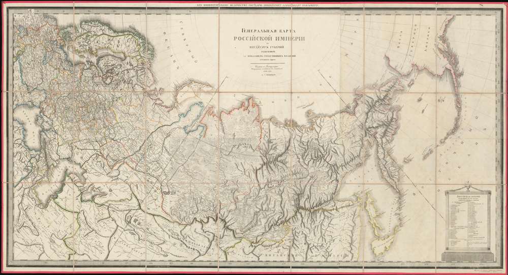
ГЕНЕРАЛЬНАЯ КАРТА РОССIЙСКОЙ ИМПЕРIИ HA ПЯТДЕСЯТЪ ГУБЕРНIЙ РАЗДЂЛЕННОЙ, съ ПОКАЗАНIЕМЪ СОСЕДСТВЕННЫХЪ ВЛАДЂНІЙ и большихъ дорогъ. / A General Map of the Russian Empire Divided into the Fifty Provinces, Showing Neighboring Domains and Highways.
1809 (dated) 32.6 x 60 in (82.804 x 152.4 cm) 1 : 7500000
1809 (dated) 32.6 x 60 in (82.804 x 152.4 cm) 1 : 7500000
Description
An exceptionally rare 1809 large-format map of the Russian Empire by Alexsandr Dmitrievich Savinkov. This is the largest and most important map published during Savinkov's tenure at the Saint Petersburg Imperial Map Depot. Presented on a conic equidistant projection, Savinkov's map covers the Russian Empire in all of its expansiveness, from Finland, annexed into Russia in the year this map was made, to Russian Alaska, and from the Arctic to Mongolia. It is dedicated to Savinkov's patron, Tsar Alexander I or Alexander Pavlovich (1777 - 1825), who ruled from 1801 to 1825. The whole exhibits Savinkov's distinctive and exceptional fine engraving style.
Historical Context
This map appeared at the height of the Napoleonic Wars (1803 - 1815). Tsar Alexander I was happy to leverage the Boneparte's chaos to his own advantage. The Emperor and the Tzar, Napoleon Boneparte and Alexander I, respectively, signed the July 7, 1807 Franco-Russian Treaty, which temporarily ended conflict between the two mighty empires, freeing France to focus on its war against the British Empire, and Russia to attempt territorial expansion in the Finnish War (1808 - 1809), the Anglo-Russian War (1807 - 1812), and the Russo-Turkish War (1806 - 1812). Russia took control of Finland in 1809, establishing the Grand Duchy of Finland, which is reflected on this map. Within three years, the alliance would fail, leading to Napoleon's disastrous 1812 invasion of Russia.The Saint Petersburg Lineage
This map follows in a lineage of expansive large-format maps of the Russian Empire dating to Tsar Peter the Great's 1725 founding of the Saint Petersburg Academy of Sciences. The Academy, with generous funding from the state, sent expeditions throughout Russia to map the expanding Empire. The achievements of these expeditions, filtering back to Saint Petersburg, were compiled by generations of talented cartographers, creating an increasingly accurate and detailed state-approved map of the Empire. Other cartographers who produced maps in this lineage include Ivan Fomich Truskot (1719 - 1786), Ivan Kirillovich Kirilov (1689 - 1737), Jacob F. Schmidt, Joseph Nicolas de L'Isle, V .P. Piadyshev (1758 - 1835), K. F. Frolov (1748 - 1810), E. M. Khudyakov (1748 / 52 - 1822), L. Sergeev (1753 – after 1799), and others. These maps, while often in Cyrillic and inaccessible to other Europeans, generally formed the basis of subsequent representation of Russia by other European cartographers.Publication History and Census
There is only one edition, engraved by Savinkov while in the employ of the Saint Petersburg Map Depot. According to text at the bottom, it was sold at Sveshnikov's Bookstores in Moscow and Saint Petersburg for 10 Rubles in 1809. Today the map is exceptionally rare, with examples noted in the institutional collections of Harvard University, the Bibliothèque nationale de France, and the Aargauer Kantonsbibliothek. No history on the private market.Cartographer
Alexsandr Dmitrievich Savinkov (1767 - c. 1849) was a Russian cartographer and engraver active in the late 18th and early 19th centuries. Little is known of his early life and education, but was born into a military family and joined the Geographical Department of the Tzar's Cabinet in 1787. There he mastered engraving under K. F. Forlov. He engraved six of the 44 maps in the 1792 Russian Atlas. He was recommended for elevation to master engraver in 1797, along with fellow engravers K. Ushakov, T. Mikhailov, and A Belousov. In the following year, 1798, Savinkov was transferred to the Map Depot where he became involved in several national mapping projections. He remained with the map depot until 1811, engraving several atlas maps (1802), a plan of St. Petersburg (1804), a postal map of the Russian Empire (1804), and atlas (1807) and a large-scale general map of the empire (1809). Throughout 1811, he severed as Commissioner of the Provisions Service, beginning his mos prolific period as a map publisher and engraver. In March of 1812, he became a member Tzar Alexander I's retinue in the quartermaster's unit, where he remained until 1818. At this time, he transferred to the Marine Printer, where he produced multiple maps until 1822. At this time, he retired with the rank of Court Councilor. While he officially retired, at just 55, he continued to publish maps for the subsequent 20 years, with his last known map being a plan of St. Petersburg, 1841. He lived at 51 Basseynaya, and had estate in Vyshnevolotsk District, where he maintained 17 serfs. More by this mapmaker...
Condition
Very good. Stable original linen backing.
References
OCLC 926093519. Shibanov, F. A. History of Russian Cartography in the 16th and 17th Centuries, Chapter 7, 'Russian Cartographer-Engravers of the 18th and 19th Centuries, pages 91 - 94.