This item has been sold, but you can get on the Waitlist to be notified if another example becomes available, or purchase a digital scan.
1966 Vietnamese City Map or Plan of Saigon, South Vietnam
Saigon-binh-1966$125.00

Title
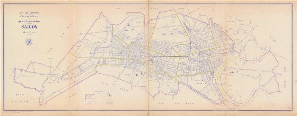
Map of the City Saigon. / Bản Đồ Dô Thành Saigon.
1966 (dated) 13 x 33 in (33.02 x 83.82 cm) 1 : 25000
1966 (dated) 13 x 33 in (33.02 x 83.82 cm) 1 : 25000
Description
This is a 1966 city map or plan of Saigon, South Vietnam by the Vietnamese artist Lê thái Bình. The map depicts the city from District 7 to District 9 and from District 10 to District 8 and District 4. Streets throughout the city are labeled, and differences are noted between paved roads (two solid lines), stone roads (one solid and one dashed line), and planned roads (two dashed lines). Railroads are illustrated by thick solid lines. The city limits are highlighted by the pink lines which trace the series of three dots and a cross that denote the city limits. The yellow lines throughout the city mark the boundaries between the districts. District courts are marked by the flags with a stripe on them and police stations by the solid circle inscribed in an empty one. The Saigon River is illustrated on the map's right side.
Publication History
This map was drawn by Vietnamese artist Lê thái Bình and published by the General Department of the Republic of Vietnam (Việt-Nam Cộng-Hòa Tổng Nha Điền Địa) in 1966.Condition
Very good. Even overall toning. Wear along original fold lines. Blank on verso.