This item has been sold, but you can get on the Waitlist to be notified if another example becomes available.
1968 Braunsdorf Map of Vicinity of Saigon, South Vietnam During the Vietnam War
SaigonPerimeter-braunsdorf-1968$375.00

Title
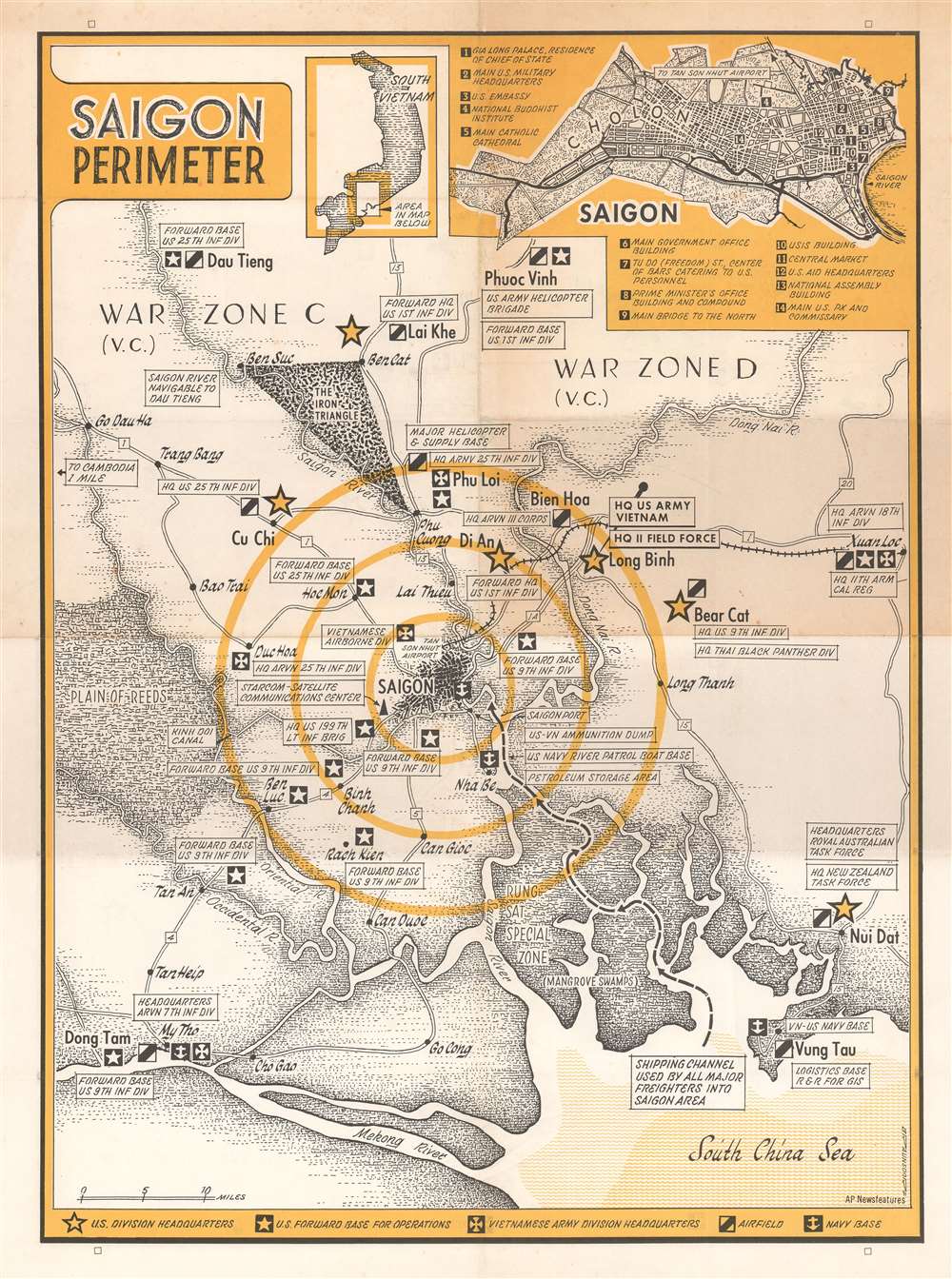
Saigon Perimeter.
1968 (undated) 21.5 x 16 in (54.61 x 40.64 cm) 1 : 316800
1968 (undated) 21.5 x 16 in (54.61 x 40.64 cm) 1 : 316800
Description
This is a c. 1968 G.W. Braunsdorf map of the vicinity of Saigon, South Vietnam during the Vietnam War. Depicting the region from Go Dau Ha to Xuan Loc and from Dau Tieng to the Mekong River and the South China Sea. Saigon is illustrated just below center with concentric circles emanating out from the city. U.S. Army division headquarters are marked by yellow stars, and each are labeled, marking the headquarters of the U.S. 25th Infantry Division, 9th Infantry Division, 11th Armored Cavalry Regiment, and the 199th Light Infantry Brigade, among others. The division headquarters of several South Vietnamese army divisions are also identified, along with forward headquarters of several American infantry divisions. Airfields and naval bases are also indicated. An inset map of Saigon itself is situated in the upper right corner and identifies fourteen important locations around the city. Some, such as bars that catered to American personnel, the central market, the U.S. Embassy, main U.S. military headquarters, and the main U.S. PX and commissary would be important to Americans in Saigon, while others, such as the National Buddhist Institute and the main Catholic cathedral, would have been of more touristic interest. A second, smaller inset situates the larger map in respect to the rest of the country.
The Vietnam War in 1968
1968 saw the height of American engagement in the Vietnam war, but it also saw what could be described as the beginning of the end. American forces in Vietnam reached their highest in 1968, after President Johnson authorized an increase in troop strength to 549,500. It was also the most expensive year in the war for the Americans, who spent $77.4 billion that year (equivalent of $569 billion in 2020). The Tet Offensive, perhaps the most famous event of the war, was launched by the North Vietnamese Vietnam People's Army and the Viet Cong throughout South Vietnam at the end of January. This offensivePublication History and Census
This map was created by G.W. Braunsdorf and published by AP Newsfeatures c. 1968. We dated the map based on the presence of certain U.S. army divisions, but it is not exact. The map could have been printed a few years earlier or later than the estimated date given here. We have been unable to unearth any information about G.W. Braunsdorf and this is the only known example of this map.Condition
Very good. Exhibits toning. Light wear along original fold lines.