This item has been sold, but you can get on the Waitlist to be notified if another example becomes available, or purchase a digital scan.
1867 Inger View of Salt Lake City, Utah
SaltLakeCity-inger-1867$4,250.00

Title
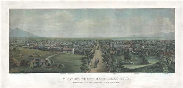
View of Great Salt Lake City.
1867 (dated) 14 x 31 in (35.56 x 78.74 cm)
1867 (dated) 14 x 31 in (35.56 x 78.74 cm)
Description
This is a very rare 1867 Christian Inger view of Salt Lake City, Utah. The view illustrates Salt Lake City looking down Main Street as it appeared roughly 20 years following the arrival of the Mormons. The development, in such a short period of time, is remarkable as Inger's view illustrates and sprawling modern city. The Rocky Mountains are in the background and Great Salt Lake appears to the right. The Mormon Temple and Tabernacle are prominent at center, as re Brigham Young's House (Beehive House) and the old City Hall. Pasturelands fill the foreground and stage coaches ply the main thoroughfare.
This view features a notable and amusing error in perspective. The size of the horses in the foreground stage coach are relatively tiny when compared to, say the cattle and sheep at the same level. If corrected mathematically for proportion, the carriage in the foreground would be larger than the towering Mormon Temple at center!
This map was drawn by Christian Inger. It was published by Philip Ritz of Walla Walla, then in Washington Territory, and printed in Philadelphia by J. Toudy. This view is extremely rare. While the OCLC identifies numerous examples, almost all refer to a 1969 photographic reprint issued in Ithaca, New York, by Historic Urban Plans from an original in the Amon Carter Museum of Western Art, Fort Worth, Texas. The original 1867 issue, as here, is extremely rare and known in only a couple of examples, most held in instructional collections. Some examples have additional text under the imprint, but this may be exclusive to the 1969 reprint.
CartographerS
Christian Inger (1814 - c. 1895) was a German born lithographic artist active in Philadelphia, in the middle to late 19th century. Inger was born in Germany and immigrated to the United States in 1854 on board the ship 'City of Washington.' He settled in Philadelphia and began working with P.S. Duval and Louis Haugg, producing lithographic images including advertisements, portraits, and landscapes. The outbreak of the American Civil War led to a downturn in business, but Inger was able to capitalize on events by issuing a series of Civil War scenes. After the war, he began issuing bird's-eye views, in partnership with various publishers. Among his work are several important views of the 1876 Philadelphia Centennial Exhibition and an important view of Salt Lake City, Utah. More by this mapmaker...
Philip Ritz (October 5, 1827 - February 7, 1889) was an American statesman, orchardist, and publisher based in Walla Walla, Washington Territory. Ritz was born in Bartville, Pennsylvania. He followed the Gold Rush to California, living for a short period in Placerville, before moving to Corvallis, Oregon by 1850. There he established himself as an Orchardist, planting over 100,000 trees. From 1866 he became an ardent supporter of the Northern Pacific Railroad, like due to his experience traveling throughout Oregon as an orchardist. He wrote various appeals to Congress to support the railroad and acquire more than 10,000 acres of Washington real estate. and was an early emigrant to Washington Territory, where he became a successful orchard owner and local statesmen. In 1889, Ritz ran against Miles C. Moore in an unsuccessful bid for the governorship of Washington Territory. The town of Ritzville, Washington, is named after Ritz, who founded a homestead there in 1878. Learn More...
Henry J. Toudy (fl. c. 1857 - c. 1877) was an American lithographer, engraver, and map publisher active in Philadelphia during the middle part of the 19th century. Little is known of Toudy's parentage or early life, but he established a steam lithography press in Philadelphia around 1856. Toudy was best known as a printer of city and town views, with many such productions bearing his imprint. He also published portraits, railroad bonds, stock certificates, and map. Toudy's original offices were located at 503 and 505 Chestnuts Streets. Insurance records suggest that Toudy's Chestnut Street offices were gutted by fire on March 25, 1879. Records suggest that the Toudy firm was reestablished in 1884 at 829 Walnut Street. In 1892 a Henry J. Toudy is recorded as the owner of the Greenback Coilliery, a mine in Shamokin, PA famous for a terrible explosion that had occurred years earlier under another owner. It is unclear if they are the same person or possibly related, but such is neither unlikely nor impossible. Learn More...
Condition
Very good. Professional resotration and remargining.
References
Reps, John, Views and Viewmakers of Urban America (University of Missouri, Columbia, 1984), 4091, plate 47, page 21.