1956 Deposito Hidrografico Nautical Chart of San Antonio Port, Ibiza
SanAntonioIbiza-depositohidrografico-1956$175.00

Title
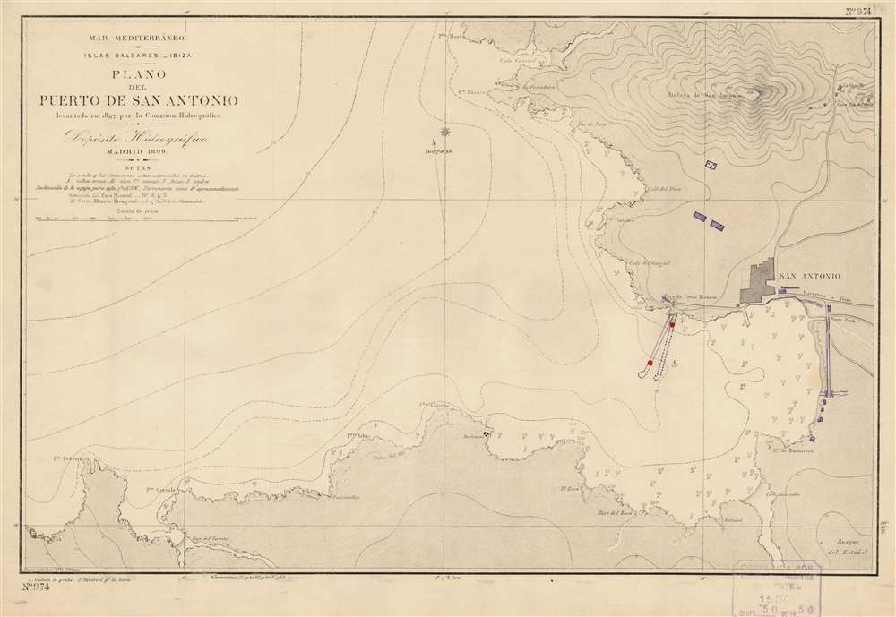
Mar Mediterráneo. Islas Baleares. Ibiza. Plano del Puerto de San Antonio.
1956 (dated) 13.25 x 19.25 in (33.655 x 48.895 cm) 1 : 10000
1956 (dated) 13.25 x 19.25 in (33.655 x 48.895 cm) 1 : 10000
Description
This is a 1956 Depósito Hidrográfico nautical chart or maritime map of San Antonio Port on Ibiza in the Balearic Islands. Today known as Sant Antoni de Portmany, the city of San Antonio is situated along the map's right side, offering mariners an unobstructed depiction of the port's approaches. Depth soundings in meters occupy the innermost parts of the bay. Lines across the bay, and the Balearic Sea mark off ten-meter increments of open ocean. A handful of locations are noted in the region, including a house and group of huts. Manuscript notations indicate a pier that moved slightly to the west since one is marked by dashed lines and the other by solid lines. Other manuscript additions illustrate buildings and the extension of a road. The cemetery has also been crossed out in manuscript.
The Clubbing Capital of the World
Before the influx of hotels and tourists in the mid-1950s, San Antonio was a small fishing village on the west coast of Ibiza. Today, it is recognized by British clubbers as the clubbing capital of the world.Publication History and Census
This chart was first published in 1899 by Depósito Hidrográfico. Three subsequent printed editions with corrections were published, with the last appearing in 1953. The present example dates from the 1953 printing, but a stamp in the lower right corner dates the manuscript additions to December 15, 1956. An example of the 1899 edition is cataloged in OCLC and is part of the collection at the Biblioteca Nacional de España.Cartographer
The Direccion Hidrografía (1787 - 1927), also known as the Deposito Hydrografico and the Direction de Hidrografía, was the Spanish equivalent of the British Admiralty or the U.S. Coast Survey. This organization, founded in 1787, was commissioned to collect and produce accurate nautical charts of all waters frequented by Spanish vessels. In essence, it replaced the Casa de la Contratación de las Indias (House of Trade of the Indies), which closed its doors in 1790. Like most such organizations, the Direccion Hidrografía marked a new age in cartography. Rather than simply collect charts created by navigators, explorers, and merchants, the Direccion Hidrografía worked closely with naval and military personnel to mount cartographic and hydrographic expeditions in pursuit of the most accurate hydrographical, astronomical, and geodetic measurements. The Direccion Hidrografía created a massive library of nautical charts that, though not nearly as common as similar nautical charts by the U.S. Coast Survey and British Admiralty, are highly desirable for the beauty of their manufacture as well as their accuracy and detail. The office was originally located on Calle Ballesta, but relocated to 36 Alcala, both in Madrid. After 1908 the Dirección was subsumed into other governmental agencies. In 1927 the Direccion was absorbed into the Institute and Observatory of San Fernando, located in Cadiz. The library of original maps, charts, and journals was transferred to the Naval Museum of Madrid - where it resides to this day. More by this mapmaker...
Condition
Very good. Exhibits manuscript additions in ink.
References
OCLC 807646388 (1899 edition).