
1935 Bloodgood Pictorial Map of San Diego / California Pacific International Expo

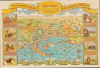
San Diego. The California Pacific International Exposition.
Iconic pictorial map of San Diego.
- Digital Map Information
- Suitable for large format printing
- Full resolution TIFF file
- ICC color profile embedded
- Delivered instantly via download link
Iconic pictorial map of San Diego.
This 1935 Don Bloodgood double-sided pictorial map of San Diego and the California Pacific International Exposition was published by Shell Oil to promote travel to the city's Depression-era world's fair. One side presents the region as an expansive playground of beaches, boating, country excursions, and cross-border sightseeing; the other brings visitors into the exposition grounds at Balboa Park. Its illustrated history makes transportation the thread connecting Spanish exploration to modern motoring and aviation. Shell's sponsorship takes architectural form within the map itself: a conspicuous shell-shaped information building stands among the fair's attractions.A Closer Look
The regional map looks eastward from an imaginary vantage point above the Pacific, placing north toward the left. Coverage extends from La Jolla to Oneonta and the Mexican border, reaching inland to Cuyamaca Dam. Downtown San Diego occupies the center, with Coronado and Point Loma projecting into a foreground crowded with swimmers, fishermen, sailors, and improbable aquatic mishaps. Circular vignettes enlarge La Jolla's beach, Old Town's Ramona Wishing Well, the exposition's California Tower, Coronado's hotel and waterfront, and the tower at Agua Caliente across the border.Bloodgood makes the landscape legible through activities as much as place-names. Grapes fill Poway Valley, poultry occupy Santa Maria and El Cajon Valleys, and orchards and cultivated fields spread through the hinterland. Sweetwater and Otay Reservoirs punctuate the hills. Lindbergh Field, aircraft, naval vessels, railways, and highways introduce the infrastructure of a modern port city, but their treatment remains comic: a sailor handles a miniature warship, an aviator dangles beneath a parachute, and a motorist approaches a border populated by exaggerated tourist and Mexican caricatures. The title cartouche advertises an exceptionally mild climate through San Diego's claim to possess 'the shortest thermometer in the world'.
The elaborate border presents eight historical scenes, several signed by Forrest Shaffer. Ships, burros, covered wagons, the Pony Express, stagecoaches, railways, automobiles, and aircraft organize the accompanying story around progressively faster travel. Its endpoint is the 1935 exposition, reached by air on a dawn-to-dark schedule. This is a promotional history rather than a neutral chronology: European arrival and American settlement become stages in a narrative of progress culminating in the tourist's own visit. Five mission views along the bottom reinforce the romantic Southwestern setting: San Gabriel, Santa Barbara, San Diego de Alcala, San Juan Capistrano, and San Xavier. Handwritten annotations also appear within the regional map, including near Sweetwater Valley and Point Loma.
The Exposition on the Verso
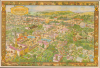
The reverse presents an expansive bird's-eye view of the fairgrounds, dated May 29 to November 11, 1935, in its upper-left cartouche. The California Tower anchors the foreground at left, while the Botanical Building, reflecting pools, and principal exhibition palaces occupy the center. The House of Charm, House of Hospitality, Palace of Fine Arts, Palace of Photography, and Palace of Education are individually identified. Bloodgood fills their surroundings with a parade, photographers, visitors scaling buildings, families, policemen, and people disregarding the injunction to keep off the grass.The map also records the fair's contrasting attractions. The zoo and Turtle Farm appear at upper left, beyond which are the Indian Village and the concession labeled Midget City. At right, Gold Gulch recreates a frontier settlement with a saloon, stamp mill, dance hall, trading post, and staged gunplay. Nearby Zoro Gardens depicts the fair's much-publicized nudist attraction. These entertainments coexist with the Federal Housing Administration, Better Housing, and industrial displays, giving the sheet considerable documentary interest beyond its comic incidents.
Shell's large information building stands opposite the Spanish Village, with another shell-shaped information stand near the Press Building. The company's presence belonged to a wider visitor-service campaign: its exposition headquarters supplied travel brochures and displayed an animated highway map, while its filling-station network distributed information to motorists traveling to San Diego. The enormous parking areas across the background make the automobile's place in this tourist economy unmistakable. At lower right, the Ford Building and adjacent Music Bowl join displays labeled Electricity, Varied Industries, and Firestone in presenting modern industry as entertainment.
A World's Fair for Economic Recovery
Organizers created the California Pacific International Exposition to attract visitors and business during the Great Depression. It occupied Balboa Park from May 29 - November 11, 1935, and reopened following its successful first season from February 12 - September 9, 1936. The park had already hosted the California Exposition of 1915 - 1916; the later fair restored and reused surviving buildings while adding new exhibition areas.Under master architect Richard S. Requa (1881 - 1941), the exposition combined its inherited Spanish Colonial Revival architecture with new buildings drawing on modern and ancient American forms. The map preserves this juxtaposition particularly clearly, setting the ornate California Tower against the industrial pavilions of the Palisades. Restoration and new construction helped establish the architectural ensemble that survived the temporary fair, although individual buildings have subsequently been altered or reconstructed.
Publication History and Census
Don Bloodgood drew the maps for Shell Oil Company in 1935. His full signature appears at the lower right of the exposition view, whose cartouche carries Shell's dated copyright; a lower-left imprint states that it was lithographed in the United States. The regional map bears Bloodgood's initials, while the historical border illustrations include Forrest Shaffer's signature. The work was issued as a separate, double-sided color map rather than as part of an atlas.Institutional examples are recorded at Harvard University, the University of Florida, the University of California San Diego, the University of California Berkeley, and the San Francisco Public Library. An example is also represented in the David Rumsey Map Collection.
Cartographer
Donald Newman Bloodgood (October 21, 1896 - February 6, 1989), known professionally as Don Bloodgood, was an American pictorial cartographer, illustrator, and cartoonist active in California and later Sedona, Arizona, during the 20th century. Raised near Farmington, New York, he worked as a window dresser before moving west as a young man. In Cheyenne, Wyoming, his cartoon drawings brought him illustration work for the Frontier Days rodeo. His documented cartographic career began with a pictorial map of San Diego for the 1935 California Pacific International Exposition. Combining geographical information with densely packed illustrations and humorous anecdotes, he later drew tourist maps of cities, states, islands, and recreational regions. His work included the Pic-Tour maps produced by H. S. Crocker Company, with subjects ranging from San Francisco and Arizona to Washington, D.C., and Havana. Bloodgood also maintained a long association with Shell Oil, creating the Bloko Boys cartoons for its trade magazine, Shell Progress. By approximately 1966, he had settled in Sedona, where his regional cartography included maps of Navajoland and The Turquoise Triangle (1968), the latter promoting northern Arizona communities and attractions. A 1982 newspaper profile reported that he had produced 55 cartographs and was still drawing cartoons at his Sedona home. His mapmaking continued beyond the 1968 endpoint previously assigned to his career: in 1984 a local newspaper described a newly designed map of Sedona and the Village of Oakcreek prepared for the area's innkeepers' association. Further Details...
Condition
Very good. Light wear along original fold lines. Pictorial map of Exposition on verso.
References
Rumsey 8580.001. OCLC 47680123, 38518439. Marshall, David and Iris Engstrand, 'San Diego's 1935 - 1936 Exposition: A Pictorial Essay', The Journal of San Diego History, 55, no. 4 (2009), pp. 177 - 178, 180. Bokovoy, Matt, 'City Beautiful: Balboa Park and the San Diego Expositions', Perspectives on History, October 2009.