
Bloodgood, Donald Newman

Donald Newman Bloodgood (October 21, 1896/7 - February 6, 1989), known as 'Don', was an American illustrator, map maker, and cartoonist active in the middle part of the 20th century. Born in California, he relocated to Sedona, Arizona, in 1960. Bloodgood produced a large corpus of pictorial maps between 1935 and 1968, most for either Shell Oil or the Pic-Tour guide series. His first known map is the illustration of San Diego drawn for the California Pacific International Exposition in 1935. Much of Bloodgood's work was produced in conjunction with Shell Oil. His work is considered stylistically similar to that of Jo Mora.
Celebrating Oahu.
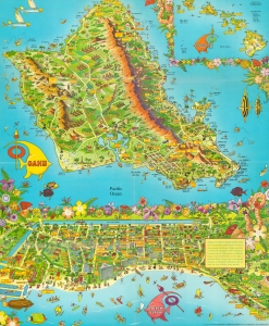
This is a 1956 Don Bloodgood pictorial map of the island of Oahu and Waikiki Beach, Hawaii. Created in two sections, the map of Oahu depicts the entire island and occupies nearly two thirds of the printed area. Sites all across the island, from Kaena Point to Makapuu Point and from Kahuku Point to Diamond Head are identified. These range from cities and towns (such as Honolulu, Lanikai, and Waialee) to beaches, including Waikiki, and other important sites, such as Pearl Harbor, the Battleship Arizona Memorial, and the Mormon Temple. Palm groves and pineapple plantations dot the landscape, while surfers and fisherman ply the waters just off shore. Fish and whales surround the island. An inset of all eight Hawaiian Islands is located in the upper right. Mauna Loa, Mauna Kea, Kilauea, and Haulalai are illustrated and labeled on the island of Hawaii, as is Mt. Waialeale, the wettest spot in the world, on Kauai. Distances from Honolulu to the other islands are given, as are distances between Honolulu and Australia, New Zealand, Tokyo, Manila, Portland, San Francisco, and Los Angeles. (more details)
Celebrating Navajo identity.
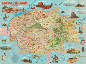
This is the 1960 first edition of Don Bloodgood's pictorial map of the Navajo Nation. The map was published for the Navajo Tribal Council to strengthen tribal identity, both internally and externally, in the face of compounded external pressure relating to the discovery of rich mineral deposits on Navajo lands, and internal crises due to poor infrastructure and endemic poverty. The map, a celebration of Navajo land and culture, was distributed for free nationally, where it drew attention to tribal causes. (more details)