1935 Jones Pictorial View of San Diego County, California
SanDiegoCounty-jones-1935-3$200.00


Title
Map of San Diego California City and County.
1935 (dated) 11 x 15.75 in (27.94 x 40.005 cm)
1935 (dated) 11 x 15.75 in (27.94 x 40.005 cm)
Description
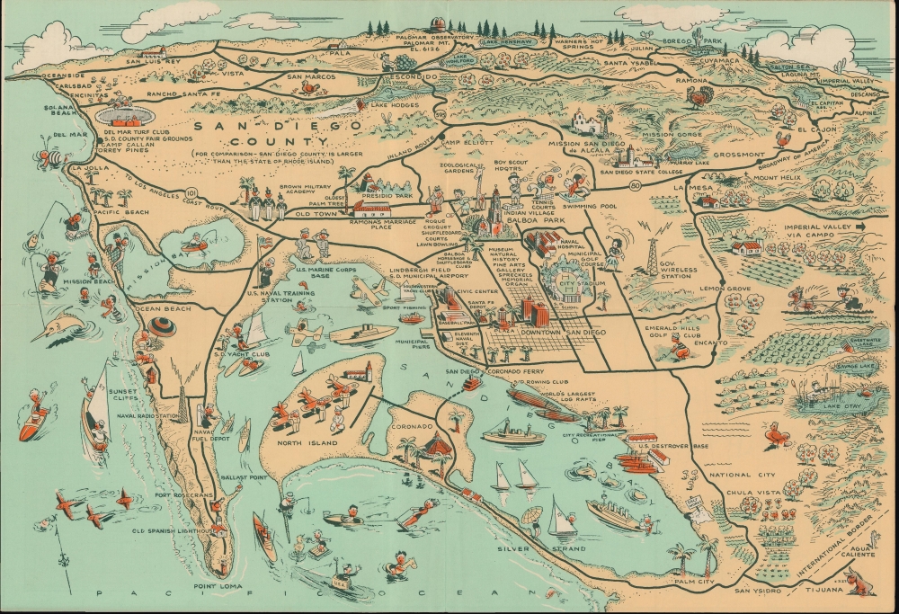
A humorous 1935 Lowell E. Jones pictorial view of San Diego. It displays the region at a time of breakneck growth, when new attractions and institutions sprung up to cater to the area's booming population.
In the years preceding this map's publication, the population of San Diego doubled, or more than doubled, each decade between 1900 and 1930. New educational, cultural, and recreational facilities emerged to serve the growing city. Those established in the mid-1930s can help to approximate the date of the view, including San Diego State College (which took on the name and moved to the location seen here in 1935), the Del Mar Turf Club (opened 1936), and Lane Field (opened 1936), the first home of the San Diego Padres. Certain local traditions, such as the Turkey Day Celebration in Romana reference here, also first appeared around this time.
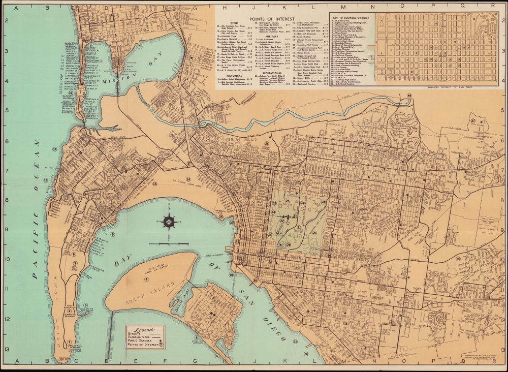
The verso includes a city plan of San Diego surrounded by a grid corresponding to a list at top and a street index on the recto when the brochure is fully folded out (the second image above). An inset of the business district with its own key appears next to the points of interest index.
There are at least two states of the map, one with the title Recreational Map of San Diego City and County and another, the present example, lacking the title; it is unclear which is earlier. Jones published a later map with the same title and format but focusing on a smaller area of San Diego County around its namesake city. Regardless of printing or state, the OCLC notes this map among the holdings of seven institutions.
A Closer Look
Oriented towards the northeast, this view covers San Diego County from Oceanside to Descanso and from Palomar Observatory to San Ysidro and Point Loma. The Salton Sea and Imperial Valley are referenced in the background at right. It features numerous pictorial vignettes illustrating the cultural, military, and sporting life of San Diego.In the years preceding this map's publication, the population of San Diego doubled, or more than doubled, each decade between 1900 and 1930. New educational, cultural, and recreational facilities emerged to serve the growing city. Those established in the mid-1930s can help to approximate the date of the view, including San Diego State College (which took on the name and moved to the location seen here in 1935), the Del Mar Turf Club (opened 1936), and Lane Field (opened 1936), the first home of the San Diego Padres. Certain local traditions, such as the Turkey Day Celebration in Romana reference here, also first appeared around this time.
The verso includes a city plan of San Diego surrounded by a grid corresponding to a list at top and a street index on the recto when the brochure is fully folded out (the second image above). An inset of the business district with its own key appears next to the points of interest index.
Publication History and Census
This view was published by Lowell E. Jones and lithographed by Frye and Smith around 1935 as part of a foldout brochure titled Map of San Diego California City and County. It is unclear if Jones was also the illustrator or simply held the copyright, though the verso map is attributed to local artist Helen Hayes Dunham.There are at least two states of the map, one with the title Recreational Map of San Diego City and County and another, the present example, lacking the title; it is unclear which is earlier. Jones published a later map with the same title and format but focusing on a smaller area of San Diego County around its namesake city. Regardless of printing or state, the OCLC notes this map among the holdings of seven institutions.
CartographerS
Lowell E. Jones (fl. c. 1935 - 1957) was a Los Angeles graphic artist. He drew pictorial maps and sold them at tourist locations around Los Angeles for twenty-five cents each. More by this mapmaker...
Helen Hayes Dunham (c. 1890 - 1960) was an artist based in San Diego. There appear to have been at least three Helen Dunhams living in San Diego around the same time, making the details of the artist's biography difficult to confirm. Moreover, the artist appears to have sometimes used the name Helen H. Dunham, and at other times Helen R. Dunham. In any event, a Helen Dunham appears in city directories as an artist or commercial artist between the 1940s and 1960s, and is known to have prepared a map of San Diego in the mid-1930s. Learn More...
Condition
Very good. Light wear along original folds. Text on recto and a second map on verso. Slight worming loss at bottom left of verso map/bottom left of text.
References
OCLC 191733991, 42393942.