1932 Candrian Map of San Francisco and San Mateo, California
SanFrancisco-candrian-1932-2$550.00


Title
Map of the City and County of San Francisco. / Map of San Mateo and Burlingame.
1932 (dated) 20 x 23.75 in (50.8 x 60.325 cm) 1 : 22500
1932 (dated) 20 x 23.75 in (50.8 x 60.325 cm) 1 : 22500
Description
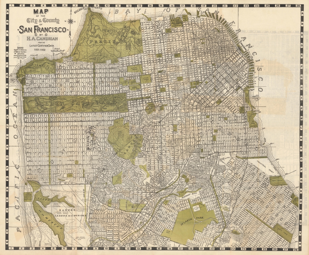
This is an appealing c. 1932 map of San Francisco and San Mateo, California, by Hermon Anton Candrian and Davenport Bromfield.
San Francisco
The primary San Francisco map covers from the Presidio as far south as McLaren Park and the Laguna de la Merced. The map names all major and minor streets as well as lakes, golf courses, piers, municipal buildings, colleges, street cars, and military installations. A series of circles indicate radial distances emanating from Ferry Building on the Embarcadero at the end of Market St.San Mateo
The verso contains two views of San Francisco and, more importantly, a large map of San Mateo and Burlingame by the resident civil engineer, Davenport Bromfield. The map offers a rare snapshot of San Mateo when it was still developing. The grand estates of several California business magnates are noted, including:- 'Uplands' - Charles F. Crocker (Southern Pacific Railroad tycoon)
- 'El Cerrito' - residence of D. Hayne
- D. F. Walker Estate
- William M. Howard Estate (founding family of San Mateo)
Forgotten Cemeteries
One clear difference between this map and a map of the city from a decade or two later would be the cluster of cemeteries around Lone Mountain near the northeast corner of Golden Gate Park. Originally built in the 1850s and 1860s, these cemeteries were at the center of a decades-long dispute between families and overseers of the deceased on the one hand and the city on the other. The parklike cemeteries had been on the edge of the city when they were built but by the early 20th century stood in the way of urban development. From 1900, the city tried to ban burials in the city and then moved to ban cremations a decade later. The city bought tracts of property to the south in Colma and began moving graves, but lawsuits held up the process, eventually reaching the U.S. Supreme Court in 1910, and the removal of graves was only completed in the 1930s with the assistance of Works Progress Administration (WPA) laborers. Today, a small portion of the Odd Fellows Cemetery remains, including a Neo-Classical domed columbarium, now tucked at the end of a residential street behind a row of shops and restaurants on Geary Blvd.The Golden Age of Street Cars
Candrian was known for his 'car-o-grams' which were a schematic representation of the city's many streetcar, cable car, and railroad lines, both public and private (shown by green lines here). These covered nearly all parts of the city, including through the Richmond District all the way to the ocean and the former estate of Adolph Sutro, the populist millionaire and one-time mayor of the city. After the 1906 earthquake, several private lines consolidated into United Railroads of San Francisco (URR), while the city began building lines for the San Francisco Municipal Railway (Muni). Eventually, Muni took control of all the lines and replaced many with trolleybuses, though seven modernized streetcar lines remain in use, along with three historic cablecars and two historic streetcar lines, the latter mostly for tourism rather than commuting.Publication History and Census
Candrian published this map from about 1906 to 1935 in various editions. This map is dated 1931-32. Well represented in institutional collections, where editions are frequently updated or erroneously dated, making a full census impossible. Scarce to the market.CartographerS
Hermon Anton Candrian (March 28, 1852 - November 28, 1928), commonly publishing as H. A. Candrian, was a Swiss-American map publisher active in San Francisco in the first half of the 20th Century. Candrian was born in Bonaduz, Graubünden, Switzerland. It is unclear when he emigrated to the Untied States, but he working as an insurance agent in Seattle around 1900 and by 1905 had relocated to San Francisco. From at least 1906, his wife, Bertha Wilhemina Candrian (née Harry; 1862 - 1944), drafted many of his maps. Candrian’s works focus heavily and tourist and railway guides to the city of San Francisco and the general Bay Area. More by this mapmaker...
Davenport Bromfield (July 2, 1862 - August 22, 1954) was an Australian Civil Engineer active in San Mateo, California in the first half of the 20th century. Bromfield was born in Warrnambool, Victoria, Australia. He immigrated to the United States in 1870, settling in San Francisco. There he apprenticed as a Civil Engineer. He held the position of Deputy County Surveyor of San Francisco for 2 years before taking a position with the Southern Pacific Railroad. He relocated to San Mateo and was elected San Mateo County Surveyor in 1890. In that position he produced several important large-scale maps of San Mateo County and City. By 1900, he established himself in private enterprise as a Civil Engineer and Surveyor. Davenport remained in San Mateo until his death in 1954. Learn More...
Condition
Very good. Some color oxidization, wear on old fold lines. Subtle archive tissue verso stabilization of a couple fold intersections on verso.
References
OCLC 213719736.