1950s General Petroleum Corporation Map or Plan of San Francisco, California
SanFrancisco-generalpetroleum-1950s$150.00

Title
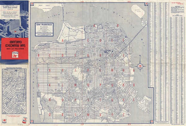
San Francisco.
1950s (undated) 18 x 22.5 in (45.72 x 57.15 cm) 1 : 32000
1950s (undated) 18 x 22.5 in (45.72 x 57.15 cm) 1 : 32000
Description
This is a nice 1950s map or plan of the city of San Francisco, California, published by the General Petroleum Corporation. The map covers the city from the Golden Gate Bridge south as far as city limits and Lake Merced. It notes all major streets, playgrounds, house numbers, piers, parks, transit lines and postal zones, along with a host of other topographical features. A street index is included on the right of the map proper. Verso features a map of Oakland titled East Bay Cities with a street index along the bottom.
The map is copyrighted by James H. Grayson in Los Angeles. Published by General Petroleum Corporation, A Socony-Vacuum Company. The map is produced by U.S. Folding Map Company and issued as an exclusive Mobilgas Dealer Service under license from Foldex, Ltd.
The map is copyrighted by James H. Grayson in Los Angeles. Published by General Petroleum Corporation, A Socony-Vacuum Company. The map is produced by U.S. Folding Map Company and issued as an exclusive Mobilgas Dealer Service under license from Foldex, Ltd.
Condition
Very good. Minor wear along original fold lines. Minor foxing.