This item has been sold, but you can get on the Waitlist to be notified if another example becomes available, or purchase a digital scan.
1927 Rand McNally Map or City Plan of San Francisco, California
SanFrancisco-randmcnally-1927$125.00

Title
Rand McNally Standard Map of San Francisco.
1927 (undated) 19.5 x 26 in (49.53 x 66.04 cm) 1 : 26600
1927 (undated) 19.5 x 26 in (49.53 x 66.04 cm) 1 : 26600
Description
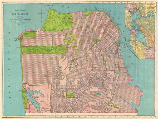
This is a beautiful map of the city of San Francisco, California, issued by the Rand McNally and Company in 1927. It covers the entire city from Fort Point and Presidio Park as far south as the Laguna de la Merced. The map is extremely detailed, showing individual buildings, major and minor streets, railroads, street car lines, parks, cemeteries, lakes, piers, reservoirs, military installations and several other important landmarks. An inset in the upper right quadrant details San Francisco and vicinity. Various topographic details are also included with elevation shown by hachure. This map was issued by the Rand McNally and Company in 1927 as part of the Rand McNally Guide to San Francisco Oakland Berkeley and Environs of The Bay Cities.
Cartographer
Rand, McNally and Co. (fl. 1856 - present) is an American publisher of maps, atlases and globes. The company was founded in 1856 when William H. Rand, a native of Quincy, Massachusetts, opened a print shop in Chicago. Rand hired the recent Irish immigrant Andrew McNally to assist in the shop giving him a wage of 9 USD per week. The duo landed several important contracts, including the Tribune's (later renamed the Chicago Tribune) printing operation. In 1872, Rand McNally produced its first map, a railroad guide, using a new cost effective printing technique known as wax process engraving. As Chicago developed as a railway hub, the Rand firm, now incorporated as Rand McNally, began producing a wide array of railroad maps and guides. Over time, the firm expanded into atlases, globes, educational material, and general literature. By embracing the wax engraving process, Rand McNally was able to dominate the map and atlas market, pushing more traditional American lithographic publishers like Colton, Johnson, and Mitchell out of business. Eventually Rand McNally opened an annex office in New York City headed by Caleb S. Hammond, whose name is today synonymous with maps and atlases, and who later started his own map company, C. S. Hammond & Co. Both firms remain in business. More by this mapmaker...
Source
Rand McNally & Co., Rand McNally Guide to San Francisco Oakland Berkeley and Environs on the Bay Cities, 1927.
Condition
Very good. Points of Interest and street index on verso. Minor wear along original fold lines.