This item has been sold, but you can get on the Waitlist to be notified if another example becomes available, or purchase a digital scan.
1960 Rand McNally Wall Map of San Francisco, California
SanFrancisco-randmcnally-1960$100.00

Title
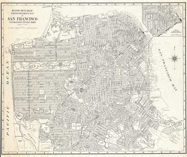
Rand McNally Indexed Reference Map of San Francisco San Francisco City Map Series.
1940 (undated) 40 x 49 in (101.6 x 124.46 cm) 1 : 12000
1940 (undated) 40 x 49 in (101.6 x 124.46 cm) 1 : 12000
Description
This is a c. 1960 Rand McNally wall map or city plan of San Francisco. The map depicts the city of San Francisco from the Pacific Ocean to San Francisco Bay and from the Golden Gate Bridge to Candlestick Park (former home of the San Francisco Giants and the San Francisco 49'ers) and Lake Merced. A highly detailed city plan, every street is labeled and city block numbers are included. Numerous sites around the city are labeled as well, including Golden Gate Park and several locations inside the park, the Golden Gate Promenade, the University of California Medical Center, the San Francisco Zoo, and the San Francisco-Oakland Bay Bridge. An inset map of the Downtown Business District is situated in the upper right corner.
This map was published by Rand McNally and Company circa 1960.
This map was published by Rand McNally and Company circa 1960.
Cartographer
Rand, McNally and Co. (fl. 1856 - present) is an American publisher of maps, atlases and globes. The company was founded in 1856 when William H. Rand, a native of Quincy, Massachusetts, opened a print shop in Chicago. Rand hired the recent Irish immigrant Andrew McNally to assist in the shop giving him a wage of 9 USD per week. The duo landed several important contracts, including the Tribune's (later renamed the Chicago Tribune) printing operation. In 1872, Rand McNally produced its first map, a railroad guide, using a new cost effective printing technique known as wax process engraving. As Chicago developed as a railway hub, the Rand firm, now incorporated as Rand McNally, began producing a wide array of railroad maps and guides. Over time, the firm expanded into atlases, globes, educational material, and general literature. By embracing the wax engraving process, Rand McNally was able to dominate the map and atlas market, pushing more traditional American lithographic publishers like Colton, Johnson, and Mitchell out of business. Eventually Rand McNally opened an annex office in New York City headed by Caleb S. Hammond, whose name is today synonymous with maps and atlases, and who later started his own map company, C. S. Hammond & Co. Both firms remain in business. More by this mapmaker...
Condition
Very good. Wear along margins. Repair to upper left corner extending 1.5 inches into printed area. Blank on verso.