
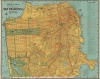
1945 Thomas Brothers Pictorial Map or Plan of San Francisco, California


This item has been sold.
Thomas Bros. Map of The City and County of San Francisco.
A whimsical mid-century map of San Francisco.
- Digital Map Information
- Suitable for large format printing
- File Size: 31.77 MB
- File Type: ZIP / TIFF
- ICC color profile embedded
- Delivered instantly via download link
A whimsical mid-century map of San Francisco.
This is the c. 1945 pictorial pocket map or plan of the city of San Francisco by Thomas Brothers.A Closer Look
Coverage extends Lake Merced in the south to the Golden Gate Bridge in the north and from Great Highway in the west to Hunters Point in the east. It notes all major streets, piers, parks, cemeteries, reservoirs, streetcar, cable car, and bus lines, and other features. A street index is included at right, corresponding to a grid surrounding the map, while a legend appears at bottom-right. Illustrations of ferries, sail boats, ships, seals, mermaids, and more appear throughout.The map reflects the state of the city around the end of World War II (1939 - 1945), when it neared a configuration resembling that of today. Some notable features are the retention of the Laurel Hill and Calvary Cemeteries, which after a long legal fight with the city had been cleared of graves (which were relocated to Colma) but had not yet been redeveloped. In the following years (late 1940s - early 1950s), they would be turned into residential neighborhoods. Ghosted in streets in the McLaren Park Site shown here were never built; although parts of the originally designated park land were put to other uses over the years. In 1946 the current boundaries of the park were fixed and it was properly developed as a park, with playgrounds, walking trails, sports fields, and a golf course.
Publication History and Census
This map was published by Thomas Brothers around the year 1945, as part of an accompanying 60-page Info-Guide containing a street index, transportation lines, hotels, points of interests and additional smaller maps. Thomas Brothers began issuing their Info-Guide for San Francisco periodically beginning around 1945, suggesting this to be the first edition of the publication. Aside from details reflecting the evolution of the city, the present example differs from later editions in the inclusion of illustrations. A map matching this description and dated 1945 is listed among the holdings of the California Historical Society, the Newberry Library, the University of Michigan, and the University of Southern Maine in the OCLC.Cartographer
Thomas Brothers (1915 – 1999) was a prominent California-based English-American publisher specializing in maps and guidebooks. Founded in Oakland in 1915 by George Copeland Thomas, Guilbert Thomas, and Leonard Thomas, the company began modestly, selling maps of movie stars' homes from a Hollywood street corner, before developing into a major cartographic and guidebook publisher. Following George Thomas's death in 1955, his widow retained attorney Warren Wilson to organize the company's affairs. When none of the Thomas heirs expressed interest in continuing the business, Wilson and accountant Tom Tripodic purchased it, preserving the Thomas Brothers tradition while pursuing a new direction and eventually relocating the company's headquarters from San Francisco to Irvine, California. The firm prospered under Tripodic, growing to more than 200 employees and dominating the West Coast map market. Rand McNally acquired Thomas Brothers in 1999, laid off many of its experienced cartographers and employees in 2003, and closed the company's remaining California operations in 2009. Further Details...
Condition
Good. Wear along original fold lines. Verso repairs to fold separations and at fold intersections. Verso reinforcement where previously attached to guidebook. Accompanied by original guidebook.
References
OCLC 66898781.