This item has been sold, but you can get on the Waitlist to be notified if another example becomes available, or purchase a digital scan.
1938 Thomas Brothers Map or Plan of San Francisco, California
SanFrancisco5-thomasbros-1938$70.00

Title
Thomas Bros Map of the City and County of San Francisco.
1938 (undated) 22 x 36 in (55.88 x 91.44 cm) 1 : 17000
1938 (undated) 22 x 36 in (55.88 x 91.44 cm) 1 : 17000
Description
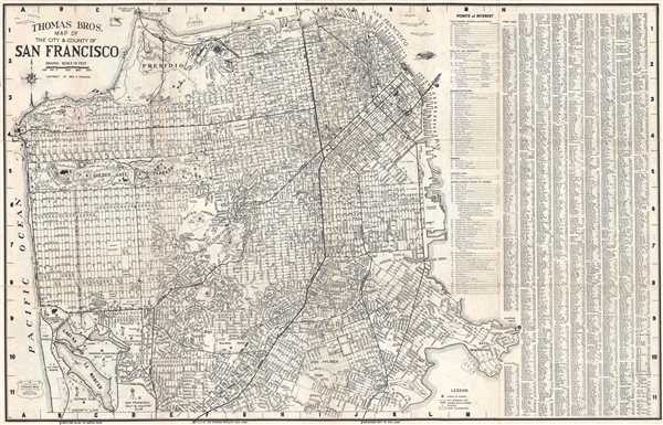
This is a c. 1938 pocket map or plan of the city of San Francisco by Thomas Bros. It depicts the city of San Francisco from the Golden Gate Bridge to Lake Merced and from the Pacific Ocean to Hunter's Point. Highly detailed, nearly all streets in the city are labeled, along with parks, cemeteries and clubs, including Golden Gate Park, which is illustrated in detail. Ninety-one 'points of interest' around San Francisco are numerically identified and correspond to an index situated in the upper right corner. A street index that lists San Francisco's streets in alphabetical order, provides the grid location of all illustrated streets. Vignettes of fishermen, mermaids, ferries, and birds populate San Francisco Bay and the Pacific Ocean that surround San Francisco.
This map was copyrighted by Geo. C. Thomas and published by Thomas Bros c. 1938.
This map was copyrighted by Geo. C. Thomas and published by Thomas Bros c. 1938.
Cartographer
Thomas Brothers (1915 - 1999) was founded by George Copleland Thomas and his two brothers in Oakland in 1915. Operating from a street corner in Hollywood, Copeland started his business by selling maps to movie stars' homes. From this, Thomas created a 'map book' / guide book institution, while carrying most of the day-to-day operating information around in his head. After George Thomas passed away in 1955, his widow hired Warren Wilson, an attorney, to straighten out the company's affairs. When it became clear that none of Thomas's heirs were interested in continuing the business, it was offered for sale. Wilson and accountant Tom Tripodic jointly purchased the company and decided to move in a new direction while 'maintaining the Thomas Brothers' tradition.' They moved the company headquarters from San Francisco to Irvine, California. The company was purchased by Rand McNally in 1999 who laid off many of Thomas Brothers' most skilled cartographers and employees in 2003 and officially closed all California operations in 2009. More by this mapmaker...
Condition
Very good. Backed on archival tissue for stability. Light toning along original fold lines. Map of Oakland, Berkeley, and Alameda on verso.
References
Rumsey 0994.015 (atlas edition).