This item has been sold, but you can get on the Waitlist to be notified if another example becomes available, or purchase a digital scan.
1952 Owens Pictorial View of the San Gabriel Valley, Los Angeles County
SanGabrielValley-owens-1952$250.00


Title
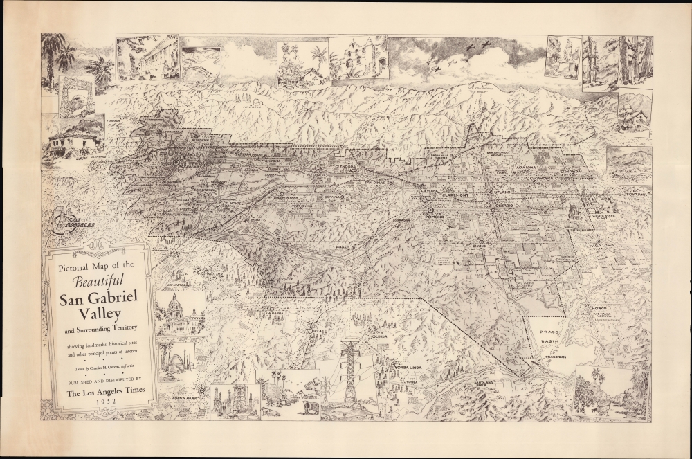
Pictorial Map of the Beautiful San Gabriel Valley and Surrounding territory showing landmarks, historical sites and other principal points of interest.
1952 (dated) 20.25 x 32 in (51.435 x 81.28 cm)
1952 (dated) 20.25 x 32 in (51.435 x 81.28 cm)
Description
An impressive unrecorded 1952 Charles H. Owens pictorial view of the San Gabriel Valley, published by the Los Angeles Times. It celebrates the climate, economy, and local landmarks in the 'SGV.'
A Closer Look
Oriented towards the north, the titular valley ranging some 50 miles across portions of Los Angeles and San Bernardino Counties is outlined and shaded, with surrounding towns, cities, and features included (downtown Los Angeles is prominent at left). Cities and towns, roads, rail lines, oil fields, local landmarks, and natural features are illustrated throughout. Large, recognizable structures include the Rose Bowl, the Cal Aero Academy, the L.A. County Fairgrounds, and Santa Anita Park in Arcadia (illustrated but not labeled). Surrounding the view are depictions of local scenes, including more famous sites, such as the Mission San Gabriel (namesake for the valley), Pasadena's City Hall, and the Mt. Wilson Observatory.Valley in the Sun
The San Gabriel Valley went through several transformations in the 20th century. Beginning as primarily agricultural land, the 1917 discovery of oil in the Montebello Hills (at left) led to the exploration and exploitation of multiple wells. This set off the development of towns throughout the valley, which grew at a tremendous pace in the post-World War II era (in an extreme example, the population of Covina more than quadrupled between 1950 and 1960). The affordability, climate, and scenery made the valley the ideal setting for the archetypal American suburb. More recently, the towns of the San Gabriel Valley have transformed again, as they have become among the most ethnically diverse in the United States. The area now has the largest concentration of Asian Americans in the country, with several cities being majority Asian-American.Publication History and Census
This view was drawn in 1952 by Charles H. Owens, an artist for the Los Angeles Times. The view is not cataloged in the OCLC, and we are unaware of it having any history on the market. Though published by the Los Angeles Times, it must have been so in a limited run to result in such scarcity.Cartographer
Charles Hamilton Owens (Feb 16, 1881 - March 3, 1958) was an American painter and illustrator and staff illustrator for the Los Angeles Times. Born in San Francisco, he had a passion for drawing from a young age. After landing a job as a messenger for The San Francisco Examiner, Owens began being taught his trade by the newspaper's illustrators. Although it is unclear exactly where Owens started his career as a newspaper staff artist, his reputation was launched by his detailed sketches of the 1906 San Francisco earthquake and fire for a New York paper, using only wire reports and his knowledge of the city. By 1910, Owens was working for the Los Angeles Examiner. Even at this point in his career, Owens was known for experimenting with new forms of illustration, fusing drawings of events with photographs. Owens's map of the Titanic disaster used a high oblique perspective, 'capturing the earth's sphericity and showing the polar regions on a curving horizon.' By the 1920s, Owens reputation as an artist in Los Angeles had grown beyond the realm of journalism. He had a studio and received commissions for landscapes and had exhibited watercolors of California and Hawaii landscapes. Thus, when Owens began creating his war series in April/May 1942, he had all the necessary skills to create visually striking works. The Los Angeles Times began a series of maps for its readers, which were full-page inserts that would appear every Monday and Saturday. Owens's maps would be included in the Monday issues, and a Rand McNally map would be included on Saturdays. The Rand McNally maps, however, were discontinued on June 27, 1942, but Owens's maps continued to be printed. His last war map was published on September 10, 1945, a little over a week after the Japanese surrender. Owens died in Los Angeles on March 3, 1958. More by this mapmaker...
Condition
Very good. Toning at left.