This item has been sold, but you can get on the Waitlist to be notified if another example becomes available.
1988 Sharon Schumacher Pictorial Map of the San Juan Islands, Washington
SanJuanIslands-schumacher-1988$112.50

Title
San Juan Islands, Washington.
1988 (dated) 23 x 35 in (58.42 x 88.9 cm)
1988 (dated) 23 x 35 in (58.42 x 88.9 cm)
Description
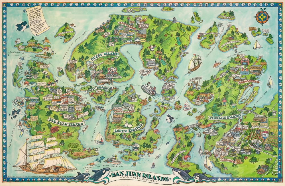
This is a 1988 Sharon Schumacher pictorial map of the San Juan Islands, Washington. The San Juan Islands are an enchanting archipelago of some 400 islands nestled between the mainland and Vancouver Island, British Columbia.
A Closer Look
The map focuses on the larger San Juan Islands: Orcas, San Juan, Lopez, and Fidalgo, as well as multiple smaller islands. Businesses are illustrated, including gift shops, boutiques, restaurants, marinas, hotels, and a pharmacy. Signs mark state parks and the two San Juan National Historic Parks. The Park commemorates the 1859 Pig War, when American and Canadian settlers on the San Juans nearly ignited a war between the United States and Britain over a dead pig. The islands are especially known for their year-round Orca population.Publication History and Census
This map was illustrated by Sharon Schumacher and published by Schumacher / Miller Design Associates in 1988. Schumacher also illustrated another map of the San Juan Islands for Marketing Concepts Unlimited in 1981. Both the 1981 and 1988 maps are scarce, with neither appearing in institutional collections.Cartographer
Sharon Schumacher (fl. c. 1980 - 1988) was an artist and producer of pictorial maps active in the early 1980s. Her work focused on the Pacific Northwest and Alaska. More by this mapmaker...
Condition
Very good. Scuffing. Closed tear extending 1 inch into printed area from bottom margin professionally repaired on verso. Closed margin tears professionally repaired on verso.