This item has been sold, but you can get on the Waitlist to be notified if another example becomes available, or purchase a digital scan.
1912 Bromfield Plat Map of San Mateo, California
SanMateo-bromfield-1912$500.00

Title
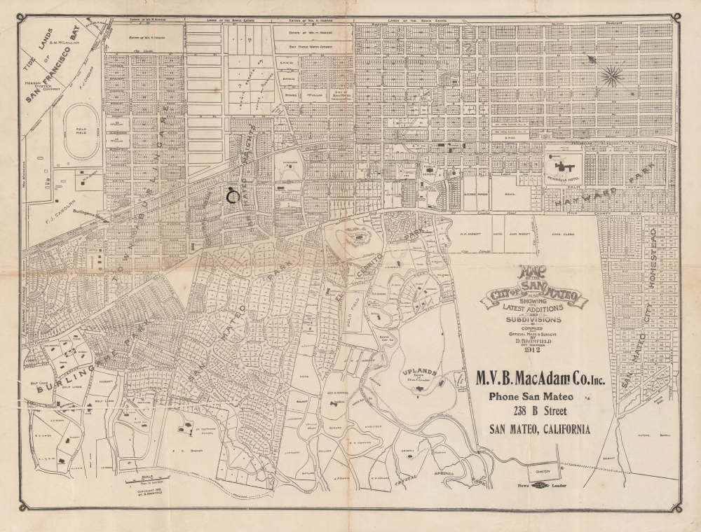
Map of the City of San Mateo showing the latest additions and subdivisions.
1912 (dated) 12.75 x 17 in (32.385 x 43.18 cm) 1 : 10750
1912 (dated) 12.75 x 17 in (32.385 x 43.18 cm) 1 : 10750
Description
A rare 1912 map of San Mateo, California by City Engineer Davenport Bromfield. It displays the city on the heels of rapid growth (the population more than doubled between 1900 and 1910), as it and surrounding communities transitioned from farming to a suburban retreat for the elite of San Francisco.
Lines belonging to the Southern Pacific Railroad cut across the map. Burlingame Station is prominent at left, while the smaller San Mateo 'R.R. Station' between Second and Third St. is difficult to notice without close examination. Present here is the Southern Pacific's Peninsular Electric Railway (often simply as the Peninsular Railway, or the 'Pin'). This service ran through today's Silicon Valley, connecting San Jose with Palo Alto, and was later extended to Oakland, but was replaced by bus lines in the late 1930s. Today, the Caltrain commuter rail runs along these tracks, connecting San Francisco and San Jose.
Other signs of the area's wealth are readily apparent. The grand Peninsula Hotel at right was a luxurious and imposing structure, but it burned down in 1920. Just to the right of the 'El Cerrito' mansion near center is a smaller property belonging to 'Gianni,' that is, Amadeo Pietro Giannini, founder of the Bank of Italy, later renamed Bank of America. During the 1906 earthquake and fire, Gianni famously used a garbage cart to evacuate the San Francisco bank's vault to his San Mateo home, then returned it to San Francisco in the following days, allowing him to carry on transactions. Other banks could not open their vaults due to the continued fires, allowing Gianni to have a brief near-monopoly, dishing out loans to help with the city's initial rebuilding efforts.
A Closer Look
Oriented towards the northeast, the map denotes block and lot numbers, as well as land ownership. Many of the lots are demarcated but not yet developed. City limits are illustrated subtly with a dashed line; in fact, much of the left side of the map is Burlingame, while the bottom is the community of Hillsborough (named by grandee William D. M. Howard for his father's native town in New Hampshire). At right is the development of the San Mateo City Homestead Association, a company dating back to 1869; the development appears here as beyond city limits but was later incorporated into San Mateo.Lines belonging to the Southern Pacific Railroad cut across the map. Burlingame Station is prominent at left, while the smaller San Mateo 'R.R. Station' between Second and Third St. is difficult to notice without close examination. Present here is the Southern Pacific's Peninsular Electric Railway (often simply as the Peninsular Railway, or the 'Pin'). This service ran through today's Silicon Valley, connecting San Jose with Palo Alto, and was later extended to Oakland, but was replaced by bus lines in the late 1930s. Today, the Caltrain commuter rail runs along these tracks, connecting San Francisco and San Jose.
San Mateo
Originally part of the Rancho San Mateo, in the late 19th century the lands and coastline of the city of San Mateo and surrounding communities were purchased by large enterprises (especially water, lumber, and oyster farming companies) and by wealthy San Franciscans seeking both investment opportunities and country estates. Some of the names present here were among the most elite families in San Francisco, including Howard and Crocker. Somewhat less prominent but still very wealthy F. (Frank) J. Carolan owns two properties at left near Burlingame Station. Soon after this map was published, he married the daughter of George Pullman and built an opulent chateau in Hillsborough known as Carolands; the home was so magnificent that the U.S. government considered buying it to use as a 'Western White House' when it came up for sale.Other signs of the area's wealth are readily apparent. The grand Peninsula Hotel at right was a luxurious and imposing structure, but it burned down in 1920. Just to the right of the 'El Cerrito' mansion near center is a smaller property belonging to 'Gianni,' that is, Amadeo Pietro Giannini, founder of the Bank of Italy, later renamed Bank of America. During the 1906 earthquake and fire, Gianni famously used a garbage cart to evacuate the San Francisco bank's vault to his San Mateo home, then returned it to San Francisco in the following days, allowing him to carry on transactions. Other banks could not open their vaults due to the continued fires, allowing Gianni to have a brief near-monopoly, dishing out loans to help with the city's initial rebuilding efforts.
Publication History and Census
This map was drawn by Davenport Bromfield, City Engineer, in 1912. Creasing across the border at left suggests it may have been copied from an earlier blueprint. An advertisement for M.V.B. MacAdam Co. indicates sponsorship of the map, while the logo of the local newspaper, the San Mateo Daily News Leader, below the title suggests their involvement in printing. There are several maps cataloged with this title, all of them very scarce. The University of California Berkeley holds a manuscript map dated c. 1906 by the same title and maker (OCLC 743363681), which may be the blueprint basis for the present map. The San Mateo County History Museum lists a smaller but very similar c.1907 map (Catalog Number 0001.046), while UC-Berkeley also lists another printing of the map from 1912 with a wider margin containing advertising for a different sponsoring company. The only other known example exactly matching the present one is held by the California Historical Society.Cartographer
Davenport Bromfield (July 2, 1862 - August 22, 1954) was an Australian Civil Engineer active in San Mateo, California in the first half of the 20th century. Bromfield was born in Warrnambool, Victoria, Australia. He immigrated to the United States in 1870, settling in San Francisco. There he apprenticed as a Civil Engineer. He held the position of Deputy County Surveyor of San Francisco for 2 years before taking a position with the Southern Pacific Railroad. He relocated to San Mateo and was elected San Mateo County Surveyor in 1890. In that position he produced several important large-scale maps of San Mateo County and City. By 1900, he established himself in private enterprise as a Civil Engineer and Surveyor. Davenport remained in San Mateo until his death in 1954. More by this mapmaker...
Condition
Good. Minor areas of loss and wear at fold intersections, professionally repaired with infill on verso.
References
OCLC 907629671. California Historical Society Call Number Map 1064.