This item has been sold, but you can get on the Waitlist to be notified if another example becomes available, or purchase a digital scan.
1747 Bowen Map of Savoy and Piedmont, Italy
SavoyPiemont-bowen-1747$75.00

Title
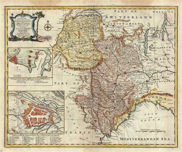
A New and Accurate Map of Savoy, Piemont, and Montserrat, Exhibiting the present Seat of War.
1747 (undated) 14.5 x 17.5 in (36.83 x 44.45 cm) 1 : 1020000
1747 (undated) 14.5 x 17.5 in (36.83 x 44.45 cm) 1 : 1020000
Description
This is a beautiful 1747 map of Savoy, Piedmont and Montserrat in northern Italy. It covers part of modern day France and Italy from Lake Geneva south as far as Nice and east as far as Milan. Several important towns and cities, including Nice, Milan, Turin, Genoa, Geneva, among others are noted throughout. It also identifies several rivers, mountains, lakes, roads and other topography. An inset of the draught of the city of Nice and town of Villa Franca with some part of the adjacent coast is featured near the left border. Another inset in the lower left quadrant features a plan of Coni, a strong fortified city situated on a hill between two rivers, which renders its approach on the east and west sides very difficult.
Coni or Cuneo, part of the Duchy of Savoy which later became part of the Kingdom of Sardinia, was an important fortress that witnessed several attack by the French. The region of Piedmont is also famous for a variety of Italian wines. The Barola and Barbaresco wines and the sparkling wine Asti, all come from this region.
The map is color coded according to regions and territories and mountains are beautifully rendered in profile. A beautifully illustrated title cartouche is featured in the upper left quadrant of the map. This map was prepared by Emanuel Bowen as plate no. 21 for the 1747 issue of A Complete System of Geography.
Cartographer
Emanuel Bowen (1694 - May 8, 1767) had the high distinction to be named Royal Mapmaker to both to King George II of England and Louis XV of France. Bowen was born in Talley, Carmarthen, Wales, to a distinguished but not noble family. He apprenticed to Charles Price, Merchant Taylor, from 1709. He was admitted to the Merchant Taylors Livery Company on October 3, 1716, but had been active in London from about 1714. A early as 1726 he was noted as one of the leading London engravers. Bowen is highly regarded for producing some of the largest, most detailed, most accurate and most attractive maps of his era. He is known to have worked with most British cartographic figures of the period including Herman Moll and John Owen. Among his multiple apprentices, the most notable were Thomas Kitchin, Thomas Jeffreys, and John Lodge. Another apprentice, John Oakman (1748 - 1793) who had an affair with and eventually married, Bowen's daughter. Other Bowen apprentices include Thomas Buss, John Pryer, Samuel Lyne, his son Thomas Bowen, and William Fowler. Despite achieving peer respect, renown, and royal patronage, Bowen, like many cartographers, died in poverty. Upon Emanuel Bowen's death, his cartographic work was taken over by his son, Thomas Bowen (1733 - 1790) who also died in poverty. More by this mapmaker...
Source
Bowen, E., A Complete System of Geography. Being a description of all the countries, islands, cities, chief towns, harbours, lakes, and rivers, mountains, mines, etc., of the known world …, (London) 1747.
Condition
Very good. Minor wear along original centerfold. Minor damp stains in top and bottom margin, not extending on to printed area. Original platemark visible. Blank on verso.
References
Rumsey 3733.020. Philips (atlases) 614 (1752 edition).