This item has been sold, but you can get on the Waitlist to be notified if another example becomes available, or purchase a digital scan.
1873 Beers Map of Sea Cliff Grove,Long Island, New York
SeaCliffGrove2-beers-1873$100.00

Title
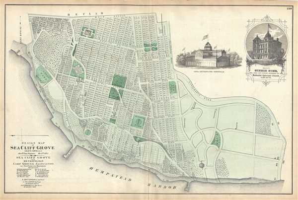
Design Map of Sea Cliff Grove, Glen Cove, L.I.
1873 (undated) 14.5 x 22 in (36.83 x 55.88 cm)
1873 (undated) 14.5 x 22 in (36.83 x 55.88 cm)
Description
A scarce example of Fredrick W. Beers' map of the Sea Cliff Grove, Long Island, New York, published in 1873. Sea Cliff Grove, named for the bluff on which it is situated, was founded in the late 19th century as a religious retreat for Methodists from New York City. The Methodists planned the town and built a huge Tabernacle and a home for the elderly and infirm – both of which are depicted as engraved vignettes on this map. This is probably the finest atlas map of Sea Cliff Grove, Long Island, to appear in the 19th century. Prepared by Beers, Comstock & Cline out of their office at 36 Vesey Street, New York City, for inclusion in the first published atlas of Long Island, the 1873 issue of Atlas of Long Island, New York.
Cartographer
The Beers family (Fredrick, Silas, James and Daniel) (fl. c. 1850 - 1886), along with Charles and Augustus Warner, were prominent map publishers working from the 1850s to the late 1880s. Often publishing under the Warner & Beers designation, the combined firms produced a series of important state and county atlases and map of much of the northeastern United States. Many of their regional maps are among the most detailed and well laid out maps ever produced of their respective regions. Because Warner & Beers county maps were often detailed down to the individual homes and landowners, they have become highly sought after by general and family historians. In additional to producing maps of surpassing detail, Warner & Beers also maintained an earlier generation's attention to detail and quality while publishing in an era ever increasingly dominated by the low cost printing methods used by the publishing empires of Rand McNally and George Cram. More by this mapmaker...
Source
Atlas of Long Island, New York. From Recent Actual Surveys and Records Under the Superintendence of F. W. Beers. (1873 First Edition)
Condition
Very good. Some wear and verso repair along original centerfold. Minor spotting. Minor edge wear.
References
New York Public Library, Map Division, 1527320. Rumsey 0066.066.