
1941 Blanton Pictorial Map of St. Simons Island and Sea Island, Georgia


Saint Simon Island and Sea Island Georgia
Rare Pictorial Map of Georgia's Golden Isles.
- Digital Map Information
- Suitable for large format printing
- File Size: 32.82 MB
- File Type: ZIP / TIFF
- ICC color profile embedded
- Delivered instantly via download link
Rare Pictorial Map of Georgia's Golden Isles.
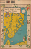
This is a rare 1941 Virginia Hilsman Blanton proof print historical pictorial map of St. Simons Island and Sea Island, Georgia. It colorfully recounts the long history of the islands, from the Native American era up to the present day (i.e. 1941).A Closer Look
The map depicts St. Simons Island, Little St. Simons Island, Sea Island, part of Jekyll Island, and portions of the Georgia mainland. Illustrations throughout refer to modern-day sites such as churches, airports, and golf clubs, while others portray local flora and historic sites, including plantation houses and the well-preserved slave cabin or Tabby House, a relic of the Antebellum Era when Saint Simons was a center of cotton production. Major roads are traced, and drawings beyond the islands include ships, the flags under which the islands have flown, and pirates. The borders of the map are likewise filled with illustrations alluding to local plants and history, from Native Americans and 16th-century Spanish explorers to pirates, the American Revolution, and into the 19th century.Historical Context
St. Simons and Sea Island boast a storied past that predates the American Revolutionary War (1775 - 1783), beginning with the Guale people and the later establishment of Spanish missions. By the mid-18th century, the region became a critical frontier for the British Empire. General James Oglethorpe founded Fort Frederica on St. Simons in 1736 to defend Georgia against Spanish Florida, a conflict that culminated in the 1742 Battle of Bloody Marsh (referred to grandiosely here as 'one of the decisive battles of the world'). This British victory effectively secured control over the Georgia coast, transforming the islands from strategic military outposts into fertile grounds for a burgeoning colonial society that would soon pivot toward plantation agriculture.During the antebellum period, the islands became the epicenter of a lucrative agrarian empire fueled by the production of a particular strain of well-regarded long-staple cotton called Sea Island Cotton, still prized globally for its silky texture and exceptional strength. Cotton production defined the islands' social and physical landscape until the Civil War, leaving behind a complex legacy of immense wealth and the profound, enduring influence of the Gullah / Geechee culture, which preserved West African traditions against the backdrop of the plantation system.
Publication History and Census
This map was prepared by local artist Virginia Hilsman Blanton and is copyrighted by Sylvia Snitcher, another local resident about whom little information is available. It is a proof sheet, as evident by markings in the top margin, including the identical images of a steeple, which are likely a registration test for the printing process. The panel at top-left suggests that it was sold locally as a souvenir. We have been unable to locate any other examples of this map in institutional collections or in market history.Cartographer
Virginia Tison (Hilsman) Blanton (May 15, 1897 - February 22, 1983) was an American artist and housewife. Born in Macon, Georgia, Blanton attended the University of Georgia and studied art in New York City. Blanton is credited with making at least three pictorial maps of coastal Georgia, one of which she composed with her son Jacob A. Blanton, Jr. She married Jacob A. Blanton, and they lived on St. Simons Island and had 2 children. Jacob A. Blanton, Sr. died September 25, 1951. Further Details...
Condition
Very good. Slight spotting, upper margin. Closed and repaired tear form lower margin extending about 3 inches through 'Battle of Bloody Marsh' panel.