
1971 Baynes Map of the Hobbit Bilbo's Journey through Eriador and Rhovanion


This item has been sold.
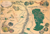
There and Back Again a Map of Bilbo's Journey through Eriador and Rhovanion.
'In a hole in the ground there lived a hobbit...' -J.R.R.T.
'In a hole in the ground there lived a hobbit...' -J.R.R.T.
This is the first U.S. edition of the iconic 1971 poster map of J. R. R. Tolkien's Middle-earth drawn by Pauline Baynes to promote The Hobbit. Tolkien heaped praise upon Baynes' work, saying, 'They are more than illustrations, they are a collateral theme. I showed them to my friends, whose polite comment was that they reduced my text to a commentary on the drawings.'The Making of the Map
Coverage embraces the primary theater of The Hobbit, covering Bilbo's epic journey from Hobbiton, along the Great East Road, over the Misty Mountains, then through Mirkwood to the Lonely Mountain. Circular vignettes illustrate important sites visited on the journey, including Elrond's House, Rivendell, Gollum's cave, the Shire, Bilbo's house, Bag End, Dale, Beorn's house, the Elven King's Hall, and Lonely Mountain itself. The map also features locations mentioned but not visited in The Hobbit, such as the dark realm of Angmar, the Elven kingdom of Lorien, Moria Gate, the Grey Mountains, the Withered Heath, and more. Smaug, the dragon, appears at the top right.Baynes worked closely with Tolkien to complete the map, visiting and corresponding with him extensively - at one point she described him as 'not very helpful.' Later, he was apparently pleased with the map, as Baynes wrote regarding the map's release event, 'He is in great form - first names and kissing all round - and pleased with the map.'
Publication History and Census
The map was drawn by Pauline Baynes in 1970 and initially published in 1971 by George Allen and Unwin in the United Kingdom. The present example corresponds to the first U.S. printing (recognizable by its white border), also in 1971, despite the George Allen and Unwin imprint here at the bottom left. There are multiple printings of the map in different qualities, as well as two sizes: 31 1/2 x 22 in. (both U.S. and U.K.) and 36 x 24 in. (U.S. only). Some U.S. editions have the Ballantine imprint. We have seen rumors on Tolkien collector forums suggesting that there are editions with moon runes imbued into the paper, which are visible only when backlit. If such exists, we have never seen it.Since the various printings of the map tend to be cataloged together, a true census would be difficult to establish, but the OCLC records a 1971 map with this title and the Allen and Unwin imprint at 8 institutions.
Cartographer
Pauline Diana Baynes (September 9, 1922 - August 1, 2008) was an English illustrator and commercial artist. Pauline was born in Hove, Sussex, England and spent her early years in Agra and Mussoorie, India, where her father was a magistrate with the British imperial Indian Civil Service. At age 5, she returned with her mother and sister to England, where she lived a nomadic life - seeing very little of her father thereafter, who remained in India. She studied at the Beaufort School, then at the Farnham School of Art, then at the prestigious Slade School of Fine Art. During World War II she severed with the Women's Voluntary Service at the Camouflage Development Training Centre at Farnham Castle. After the war she submitted several drawing to the publisher George, Allen and Unwin, through which they caught the attention of fantasy novelist J. R. R. Tolkien. Her subsequent collaboration with Tolkien including illustrations for Farmer Giles of Ham, The Adventures of Tom Bombadil, The Hobbit, and The Lord of the Rings, among others, as well as supplementary promotional work, including several maps. Baynes' illustrations for Tolkien's, caught the attention of C. S. Lewis, who contracted her to illustrate for the Chronicles of Narnia. She continued to illustrate for books and novels until she died of ischaemic heart disease at 85. Further Details...
Condition
Good. Closed tear extending 3 inches into printed area from top edge professionally repaired on verso. Small area of infill along top edge. Pinholing in corners.
References
OCLC 9226286.