This item has been sold, but you can get on the Waitlist to be notified if another example becomes available, or purchase a digital scan.
1815 Melish Map of the Northeastern U.S. during the War of 1812
SeatofWarNorthAmerica-melish-1815$750.00

Title
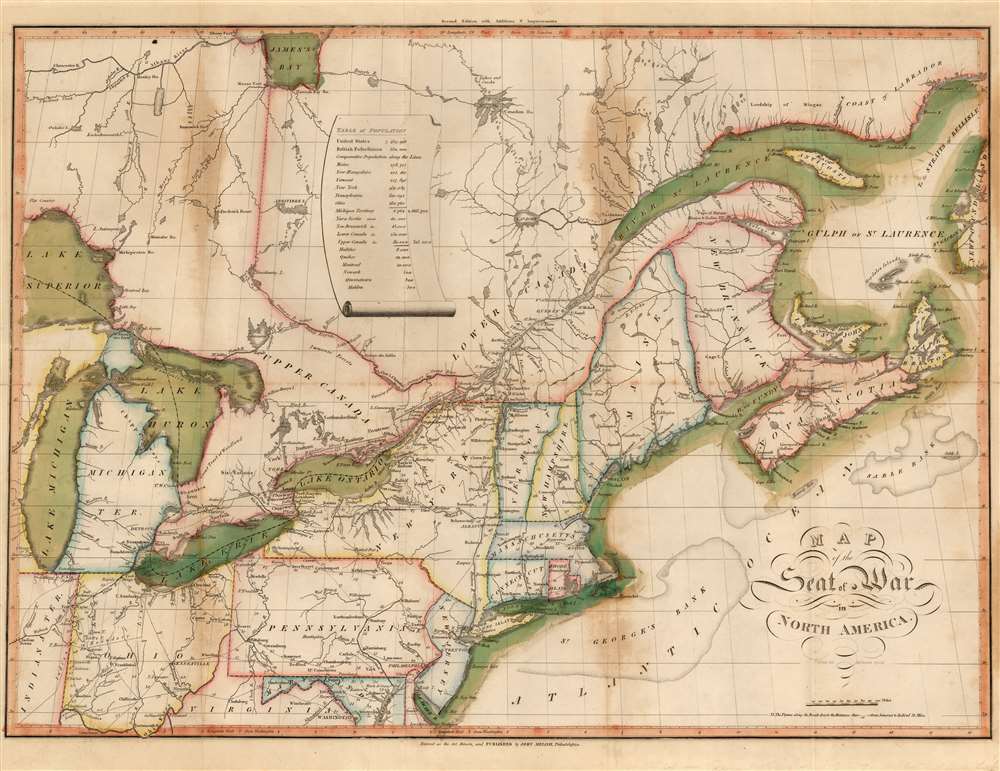
Map of the Seat of War in North America.
1815 (undated) 16 x 21.75 in (40.64 x 55.245 cm) 1 : 4118400
1815 (undated) 16 x 21.75 in (40.64 x 55.245 cm) 1 : 4118400
Description
This John Melish's 1815 map of the northeastern United States and Canada, one of the earliest works by the first American publisher to concentrate specifically on maps. It is moreover one of the earliest maps specifically relating to the War of 1812 (1812 - 1815), and is one of the few maps pertinent to the war that was printed while it was still underway. It is, moreover, one of the best Federal Period maps available to the collector. Melish drew the map prior to the declaration of the war, and published it in conjunction with his 1812 A description of the British possessions in North America. So successful was that work that the plate swiftly wore out. This second edition of the map - 'with additions and improvements' - was engraved to accompany Melish's 1813 Military and Topographical Atlas of the United States. The identical second edition appeared in the 1815 second edition of the work. Both editions were engraved by Henry Schenck Tanner, and in this respect the map represents the work of two definitive figures in American map publishing.
A Markedly Improved Map
The 1813 map is better engraved than the 1812, and offers significantly more detail throughout. Canada north of the Great Lakes, blank on the 1812 further west than Lake Abitibi, here shows James Bay, the Albany River and its tributaries, the Moose River, and a number of forts and trading houses such as Mitinabe House and the ill-fated Frederick House (a Hudson's Bay Company post whose manager and staff were murdered in the winter of 1812-13, leading to its eventual abandonment). The delineation of the Michigan Territory differs. The interior detail of the states shown is much improved, with scores more place names to accompany the travel distances and roads already shown. The ocean areas, largely blank on the original edition, ere show St. Georges Bank, the Sable Bank, and offer a more granular naming of islands and straits.Publication History and Census
The map was engraved in 1813 by Henry Schenck Tanner for inclusion in Melish's Military and Topographical Atlas of the United States. Both editions of the book are well represented in institutional collections. Eighteen examples of the separate map are recorded in OCLC, attributed to one edition or the other.CartographerS
John Melish (June 13, 1771 - 1822) was an early 19th century American writer, publisher and mapmaker based at 209 Chestnut Street, Philadelphia. Many historians consider John Melish to be the first truly great American commercial cartographer and responsible for some of the most influential maps in the history of North America. Melish was born in Scotland in 1771. As a young man he apprenticed to a Glasgow cotton merchant and in this capacity visited America no less than four times between 1798 and 1809. In 1806 Melish attempted to create his own cotton important-export company based in Glasgow, Scotland and Savannah, Georgia. Unfortunately, deteriorating relations between the United States and Great Britain resulted in the 1807 trade embargo, which all but destroyed Melish's fledgling company. In 1811 Melish finally left Scotland to permanently relocate in Philadelphia. Melish had never been truly satisfied with the quality of travel writing available regarding the new republic and so, in 1812, published his own contribution to the genre. Melish based his first major publication, the cartographically rich, Travels in the United States of America in the Years 1806 & 1807, and 1809, 1810 and 1811, on the copious notes taken during his own travels as a cotton merchant. Travels enjoyed an immediate success and even caught the eye of Thomas Jefferson, then President, who sent copies of the work to friends in France and Italy. Partially in an attempt to illustrate his own travels and partly in response to a general need for good cartographic materials, Melish turned to map publishing. By 1814 he was styling himself as a "Geographer and Map Seller" and had published several independent maps, geographies and gazetteers. Melish's most important work is most likely his iconic representation of the United States first published in 1816, Map of the United States with the contiguous British and Spanish Possessions. This visionary large format map was the first American commercial map to show the United States extending from coast-to-coast in a remarkably prescient expression of the Doctrine of Manifest Destiny. Melish died suddenly of unknown causes in December of 1822. He is buried in Philadelphia. (Carter, E. C., Surveying the Record, pages 40 - 49. Ristow, W., American Maps and Map Makers, pages 110-115. 143, 154, 166-168, 191, 246, 281, 446. Wolfgang, M.E., "John Melish: An Early American Demographer." Pennsylvania Magazine 82 (1958): pages 65-81.) More by this mapmaker...
Henry Schenck Tanner (1786 - May 18, 1858) was one of the preeminent American map engravers and publishers of the early 19th century - what is considered to be the "Golden Age of American Map Publishing". Born in New York City but based in Philadelphia, Tanner's forty plus year career was almost entirely focused on cartographic work. His earliest map work appears in conjunction with another important map publisher, John Melish. Early in his career, Tanner partnered with his brother Benjamin, to engrave extensively for Melish as well as other Philadelphia publishers including Lucas Fielding (Baltimore), A. Bourne, Jason Torey, Samuel Harrison, and Samuel Lewis, among others. In 1818 Tanner convinced his fellow publishers and partners to finance the compilation of a New American Atlas. The atlas was sold by subscription and slowly emerged between 1819 and 1823. The New American Atlas, possibly the pinnacle of 19th century American cartography and was commended in its day as "one of the most splendid works of the kind ever executed in this country". It was subsequently republished in several updated editions until about 1839. Tanner had by this time become the most active and influential map publisher in the United States. Around 1832, recognizing the market for a less cost prohibitive atlas, Tanner began work on the smaller format New Universal Atlas. This popular and important atlas went through numerous editions before being bought out by Carey and Hart, and then, in 1846, by S. A. Mitchell, who would rise to become the preeminent publisher of the next generation. In addition to these important atlases, Tanner also issued numerous extremely important and influential travelers guides, state maps, wall maps, and pocket maps. He should not be confused with his brother, also an America map engraver, the New Yorker Benjamin Tanner. Learn More...
Source
Melish, J., A Military and Topographical Atlas of the United States, (Philadelphia: Melish) 1815.
Condition
Very good. Some staining at folds and right margin. Original outline and wash color.
References
OCLC 49694084. Rumsey 2788.01. Phillips, Philip Lee, A List of Geographical Atlases in the Library of Congress, 1347.