
1901 Morrison / Robinson Cadastral Wall Map of Seattle, Washington

This item has been sold.
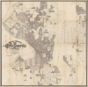
Morrison and Robinson's City of Seattle and Vicinity Compiled from Latest Official Records.
Engineering the Emerald City.
- Digital Map Information
- Suitable for large format printing
- File Size: 83.07 MB
- File Type: ZIP / TIFF
- ICC color profile embedded
- Delivered instantly via download link
Engineering the Emerald City.
This is a rare 1901 large-format cadastral map of Seattle, Washington, prepared by local political grandee and real estate financier Ellis Morrison, with A. Robinson. Capturing the city at a time of rapid development, thanks in large part to the Klondike Gold Rush, it displays many housing developments and public works in progress or planning, some of which were never completed.A Closer Look
The map covers the entirety of contemporary Seattle with portions of surrounding towns that would be annexed by Seattle in the following decades. It provides a comprehensive catalog of city blocks and lots, both of which are numbered, and is so detailed that the individual owners of larger land plots are noted, while housing developments (additions) and not-yet-developed tracts are similarly named. Red lines trace streetcar lines, and streets are labeled throughout (though many were soon renamed thanks to City Engineer Reginald H. Thomson, discussed more below). These include ghosted sections along the waterfront extending to a planned but never completed Outer Harbor Line. In fact, much of the city as presented here, especially along its northern coastline of Puget Sound, would strike a modern resident as strange, since the lots laid out here were planned but often not completed as conceived. Indeed, a close examination of the area from Fort Lawton to 'Smith's Cove Waterway' reveals the tracing of the existing coastline, with everything beyond that being planned future development.Other elements do correspond to the city's later trajectory, including the relocated (in 1895) campus of the University of Washington; the mostly empty university grounds were utilized for the Alaska-Yukon-Pacific Exposition in 1909, after which the number of university buildings on campus increased considerably. The 'Gov't Canal' seen here is the Fremont and Montlake Cuts, which today, along with the later Chittenden (or Ballard) Locks (at Salmon Bay Waterway), link Lake Washington and Lake Union with the Pacific Ocean, a project long discussed and debated but uncompleted at the time of publication.
Historical Context
Bouncing back from a devastating fire in 1889, the Seattle illustrated here was booming due to the 1897-99 Klondike Gold Rush. Leveraging a masterful marketing campaign, Seattle successfully branded itself as the 'Gateway to the Gold Fields.' An influx of prospectors flooded the city, creating an insatiable demand for supplies, transportation, and lodging. Seattle's newfound wealth was immediately funneled into an ambitious and aggressive reimagining of the region's difficult topography. Under the direction of visionary City Engineer Reginald H. Thomson, Seattle embarked on massive regrades, where entire hills (most notably Denny Hill) were excavated and washed into Elliott Bay to create flat land for a burgeoning business district, including Harbor Island (towards bottom-left here), the largest artificial island in the world when completed in 1909.Simultaneously, the city invested heavily in permanent infrastructure, including the canal system mentioned above, the construction of the Cedar River Watershed system to provide clean water, and the development of a sophisticated park system designed by the Olmsted Brothers. Thomson also oversaw the straightening and deepening of the Duwamish River, the construction of a seawall (marked here with a dashed line) to protect the city's waterfront, an expansion of the waterfront itself (using more landfill), and the development of a modern sewage and electrical system. These public works were not merely functional, but signaled Seattle's transition from a rugged frontier outpost to a modern, world-class city.
Publication History and Census
This map was prepared by Ellis Morrison and A. Robinson, a local real estate developer, in 1901, with printing handled by the Jacob Manz Engraving Co. in Chicago. Between 1895 and 1905, Morrison also issued a smaller-format map of Seattle ('Official guide map of Seattle Compiled from latest official records') with his regular business partner Albret D. Eshelman, which is itself quite scarce. The present map is rare, only appearing in the collections of the Seattle Public Library, the University of Washington, the Huntington Library, and the University of Minnesota.Cartographers
Ellis Morrison (May 20, 1849 - September 13, 1914) was a businessman and politician who played an important role in the development of Seattle, Washington, after a devastating 1889 fire through the Klondike Gold Rush. Born in Butler County, Pennsylvania, Morrison attended the Pennsylvania Military College (now Widener University) and graduated in 1871 with a degree in civil engineering. Afterward, he worked as an engineer for the New York and Oswego Midland Railroad. After a brief diversion into the study of law, Morrison became the city engineer of Newcastle, Pennsylvania, a role he held for 10 years. He helped design water systems in Newcastle and other towns in Pennsylvania, Ohio, and Indiana. From 1880 until 1885, he was a member of the Pennsylvania legislature. In 1890, he relocated to Seattle, Washington, which was then recovering from a fire that had destroyed much of the downtown portion of the city. Morrison drew on his engineering experience to enter the real estate market, running a financial services firm that offered bonds and mortgages. He also continued his involvement in politics, being elected to the Washington state legislature in 1892 and briefly serving as Speaker of the House, and later being nominated as a candidate for lieutenant governor on an unsuccessful ticket. Morrison also served on the Seattle City Council. Further Details...
Jacob Manz, Jr. (October 1, 1837 - April 25, 1916) was a Swiss-born engraver who was among the most prominent engravers in Chicago at the turn of the 20th century. Born in Marthalen, Switzerland, Manz was apprenticed to a wood engraving firm in Schaffhausen, but the firm dissolved before he could finish his apprenticeship. Facing dim prospects in Europe, he emigrated to America and arrived in Chicago in 1855, among the earliest engravers working in the city. He initially found employment as an engraver for S. D. Childs and Company, and later W. D. Baker. In 1866, he and another engraver surnamed Maas launched their own firm, but Manz became the sole proprietor of the business within a few years. Manz was nearly wiped out by the Panic of 1871, but rebuilt his company (now J. Manz and Company) from the ground up and by the end of the century had become a major player in the heady world of Chicago printing and publishing. Manz added lieutenants with business chops, acquired competitors, and moved to larger premises. By the time of Manz's death in 1916, the firm employed several hundred people, including staff artists (one being the esteemed commercial artist J. C. Leyendecker, 1874 - 1951). Manz had already passed on management of the firm to associates who carried on the company after his death, but it eventually fell into bankruptcy in 1962. Further Details...
Condition
Good. Slight discoloration and verso reinforcement along most fold lines and slight reinstatement at some fold intersections. Stains near title. Light pencil annotations near center.
References
OCLC 62501177, 83983615.