1750 Bellin Map of the Senegal
Senegal-bellin-1750$175.00
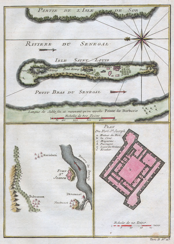

Title
Riviere du Senegal / Isle Saint Louis / Petit Bras du Senegal / Plan du Fort St. Joseph.
1750 6.5 x 9 in (16.51 x 22.86 cm)
1750 6.5 x 9 in (16.51 x 22.86 cm)
Description
This stunning 1747 nautical chart by French mapmaker J. C. Bellin, the Elder depicts the Senegal River and the area surrounding Fort St. Joseph & Fort St. Louis. This region was part of the Senegambia & the Company of the Indies Senegal Concession. It was from this port that the French company shipped hundreds of African slaves to its colonies in Louisiana. Today the Senegal River forms the important border between Senegal and Mauritania. This beautiful map depicts individual buildings, trees, and even tiny villages. There is a detailed plan of Fort St. Joseph..
Cartographer
Jacques-Nicolas Bellin (1703 - March 21, 1772) was one of the most important cartographers of the 18th century. With a career spanning some 50 years, Bellin is best understood as geographe de cabinet and transitional mapmaker spanning the gap between 18th and early-19th century cartographic styles. His long career as Hydrographer and Ingénieur Hydrographe at the French Dépôt des cartes et plans de la Marine resulted in hundreds of high quality nautical charts of practically everywhere in the world. A true child of the Enlightenment Era, Bellin's work focuses on function and accuracy tending in the process to be less decorative than the earlier 17th and 18th century cartographic work. Unlike many of his contemporaries, Bellin was always careful to cite his references and his scholarly corpus consists of over 1400 articles on geography prepared for Diderot's Encyclopedie. Bellin, despite his extraordinary success, may not have enjoyed his work, which is described as "long, unpleasant, and hard." In addition to numerous maps and charts published during his lifetime, many of Bellin's maps were updated (or not) and published posthumously. He was succeeded as Ingénieur Hydrographe by his student, also a prolific and influential cartographer, Rigobert Bonne. More by this mapmaker...
Condition
Fine or perfect condition. Original platemark visible. Wide clean margins. Blank on verso.