This item has been sold, but you can get on the Waitlist to be notified if another example becomes available, or purchase a digital scan.
1899 Pujol Map of the St. Louis - Dakar Railroad, Senegal
Senegal-pujol-1899$1,000.00

Title
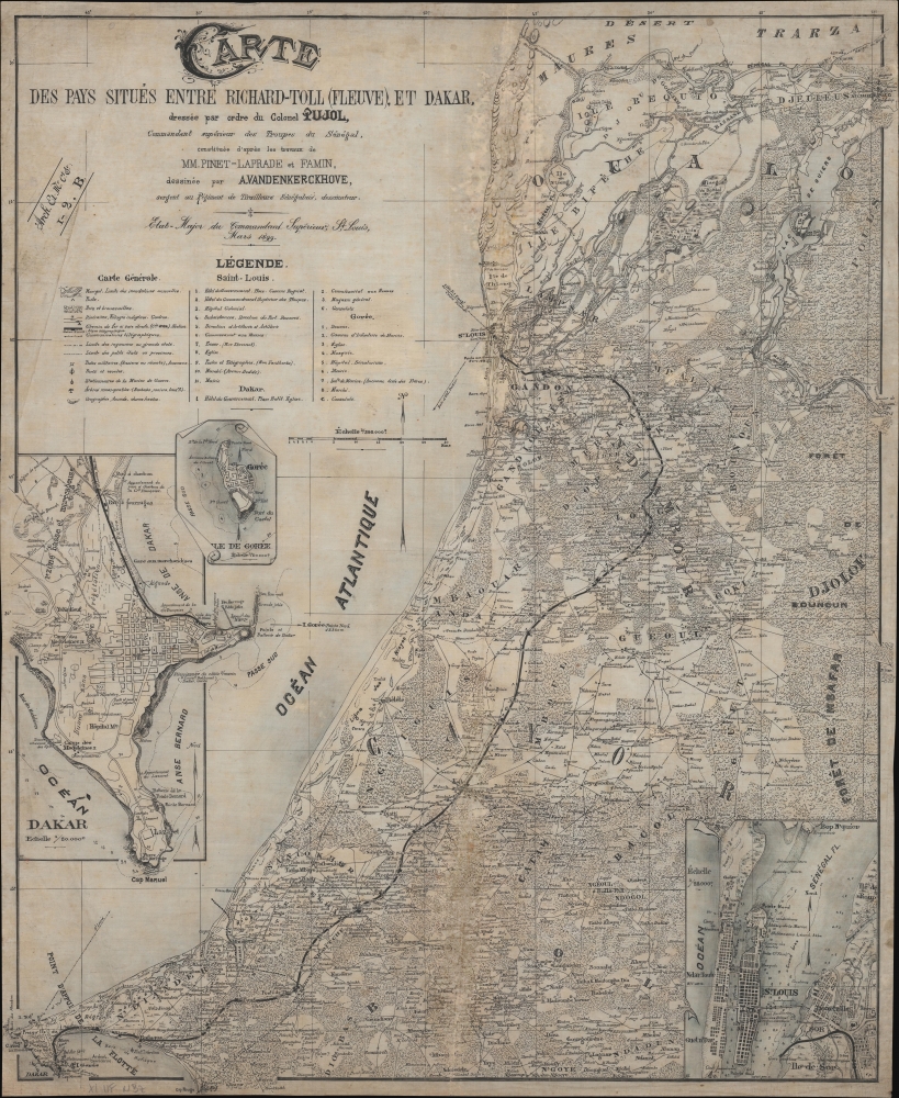
Carte des Pays Situès entre Richard-Toll (Fleuve), et Dakar.
1899 (dated) 24 x 19.5 in (60.96 x 49.53 cm) 1 : 395000
1899 (dated) 24 x 19.5 in (60.96 x 49.53 cm) 1 : 395000
Description
This is the only known example of the 1899 Pujol map of Senegal focusing on the Saint-Louis-Dakar Railroad - the primary artery of French hegemony in West Africa. The map is printed on linen-silk, intended to withstand arid weather conditions and military use. It was printed by helio-zincography, likely in Saint-Louis, capital of Afrique-Occidentale Française, and designed by A. Vandenkerckhove, a sergeant in the all-African Senegalese Skirmishers.
A Closer Look
The map focuses on western Senegal, detailing the two primary arteries of French hegemony: the Senegal River and the Saint-Louis-Dakar Railway (SLD). It is based on railroad surveys conducted under administrator Jean Marie Emile Pinet-Laprade and engineer Pierre Famin. The primary focus is this latter railway. Completed in 1885, the SLD allowed French troops and resources to quickly move between the capital at Saint-Louis and the port of Dakar. It also provided a mechanism to control the Cayor Kingdom, through which it ran. There are three detail maps artistically rendered to appear as separate sheets overlaid on the main map, with clever folds, rolls, and even tears added to create both a three-dimensional effect and maximize space. These include, Dakar, Saint-Louis, and with its dark history in the slave trade, Gorée.Saint-Louis-Dakar Railway
The Saint-Louis-Dakar Railway was the first railroad in Senegal. It connected Saint-Louis, then capital of French Senegal, to its primary port, Dakar. The value of such a railroad had been promoted for decades, not only as a means to access and exploit the resources of the interior, but also to militarily dominate the problematic Cayor Kingdom, whose Islamic populace doggedly opposed French regional hegemony. Cayor was situated between the French strongholds of Saint-Louis and Dakar, thus dividing French spheres of influence. French engineers therefore planned a railroad that would run far inland, well away from lightly populated coastal regions, deep into the densely populated Cayor heartlands. The railroad, it was believed, would allow the French to psychologically and militarily dominate Cayor. Work on the railroad began in 1878 and it officially opened in 1885. A generation later, in the 1920s, it became known as the 'Peanut Railroad', reflecting various groundnut schemes that used the railroad to transport crops. It continued to operate sporadically until about 2000.Photo-zincography and Helio-zincography
Photo-zincography and helio-zincography are similar reprographic processes popularized by the British Ordnance Survey. In 1859, photo-zincography was developed, separately but simultaneously, by John Walter Osborne in Australia and by two soldiers at the Ordnance Survey in Southampton. These soldiers, Captain Alexander de Courcy Scott and Lance-Corporal Rider, were working under the command of Colonel Henry James, who falsely took credit for the innovation. Essentially, photo-zincography is a reproductive process that uses glass photographic negatives to create carbon positive prints which are then transferred to zinc plates. Helio-zincography, while essentially the same process, eliminates the carbon positive by placing negatives directly on the zinc plate. It offers several advantages, most importantly, zinc plates are lighter and cheaper than lithographic stones, economizing the process considerably. Helio-zincography was embraced by various cartographic agencies that demanded mobility and economy, among them the British Ordinance Survey, the French Bureau Topographique, and various other military mapping agencies.Publication History and Census
This map was published and printed on linen-silk by helio-zincography in 1899, likely in Saint Louis, Senegal. It was commissioned by one 'Colonel Pujol'. This is most likely August Marie Joseph Pujol, who, around this time, held the post of Commandant des Troupes Coloniales in French West Africa. The map's remarkable design can be attributed to one 'A. Vandenkerckhove', a sergeant of the 'Tirailleurs Seneglais', or Senegalese Skirmishers, an all-African unit under the 'Troops Coloniales'. There is some evidence on the page, in terms of plate numbers, that suggest this map may have been made for some sort of military loose-leaf atlas or official map collection, although only one similar item, a map of the Senegal River, is known (see Geographicus: SenegalFleuve-pujol-1899). This is the only known example of the present map.CartographerS
August Marie Joseph Pujol (March 4, 1863 - 19xx) was a French colonial officer born in the Cammarges, France. He served in various posts from about 1880 to 1899, including Toulon (1885), Reunion (1885), Madagascar (1886), Senegal (1890), Sudan (1892), and Tonkin (1893 - 1903). In Senegal he held the rank of Etat-Major du Commandant Superior des Troupes Coloniales. The only definitive reference we have found to his service is an 1887 dispatch on the excessive rates of venereal disease among French African soldiers. More by this mapmaker...
Jean Marie Emile Pinet-Laprade (July 13, 1822 - August 17, 1869) was a French colonial military officer and engineer active in West Africa. Pinet-Laprade was born in Mirepoix, Ariège, France and studied at the École Polytechnique and later at a military engineering school at Metz. He was sent as an engineer to Gorée in 1855. Shortly thereafter, he was part of the French takeover of Dakar, after which he laid out the city on a European style grid inspired by his hometown of Mirepoix. This design became common-use in French Africa where it was known as the 'Plan Pinet-Laprade'. He became governor of Senegal from May 13 to July 14, 1863 and again from May 1, 1865 until his death of cholera in 1869. During his administration, he completed numerous engineering works, ranging from lighthouses to the instigation of a Saint Louis - Dakar railroad. Unlike most colonial administrators, Pinet-Laprade was vehemently anti-slavery, even marrying a Senegalese Fulani woman, Marie Assar (a.k.a. Peulth), who he introduced to his family in France and made his heir. Learn More...
Pierre Famin (1855 - 1922) was a French army officer, engineer, and military cartographer active in the late 19th century. He served in Senegal for a time before moving to French Indochina, where he fought in various campaigns between 1892 and 1893. He fought in World War I (1914 - 1818) and later was sent to Ethiopia to construct the Djibouti - Addis Ababa railway. He was made Grand Cross of the Legion of Honor in 1920. Learn More...
Condition
Good. Soiling and discoloration along old vertical fold. On silk-linen.