This item has been sold, but you can get on the Waitlist to be notified if another example becomes available, or purchase a digital scan.
1899 Pujol Rafting and Navigation Map of the Senegal River, Senegal
SenegalFleuve-pujol-1899$1,250.00

Title
Senegal Fleuve de St. Louis aux Chütes du Félou.
1899 (dated) 20 x 25 in (50.8 x 63.5 cm) 1 : 895000
1899 (dated) 20 x 25 in (50.8 x 63.5 cm) 1 : 895000
Description
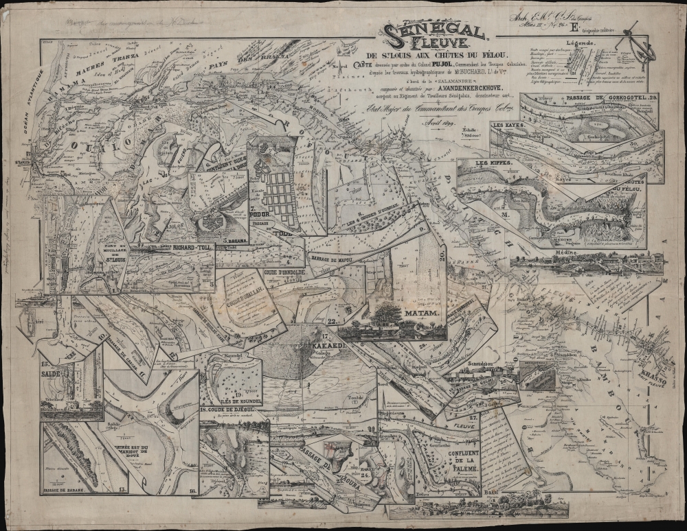
This extraordinary item is a one-of-a-kind 1899 river guide map of the Senegal River issued by 'Colonel Pujol' for use by French colonial troops. This is the earliest known printed hydrographic chart of the Senegal River, based on the 1891-1893 surveys of Henri Pierre Gabriel Buchard, themselves comprising the first hydrographic mapping of the river. The chart was printed by helio-zincography, likely in St. Louis, the capital of Afrique-Occidentale Française, and designed by A. Vandenkerckhove, a sergeant in the all-African Senegalese Skirmishers.
A Closer Look
The map is a wonder of design, tracing the course of the Senegal River from Saint Louis, capital of Afrique-Occidentale Française, to the Chûtes de Félou, the furthest navigable point. The main map begins in the upper left before cutting at a southward diagonal across the page to end in the lower right. The cartography also includes navigable parts of the Falémé River, which currently forms the Senegal-Mali border, as far as Kholoba. Significantly there are 31 detail maps artistically rendered to appear as separate sheets of paper overlaid on the main map, with clever folds, rolls, and even tears added to create both a three-dimensional effect and maximize space. Some of the subcharts feature beautifully rendered views of riverside towns and forts. The most important noted towns are Saint Louis, Richard-Toll, and Bakel.Photo-zincography and Helio-zincography
Photo-zincography and helio-zincography are similar reprographic processes popularized by the British Ordnance Survey. In 1859, photo-zincography was developed, separately but simultaneously, by John Walter Osborne in Australia and by two soldiers at the Ordnance Survey in Southampton. These soldiers, Captain Alexander de Courcy Scott and Lance-Corporal Rider, were working under the command of Colonel Henry James, who falsely took credit for the innovation. Essentially, photo-zincography is a reproductive process that uses glass photographic negatives to create carbon positive prints which are then transferred to zinc plates. Helio-zincography, while essentially the same process, eliminates the carbon positive by placing negatives directly on the zinc plate. It offers several advantages, most importantly, zinc plates are lighter and cheaper than lithographic stones, economizing the process considerably. Helio-zincography was embraced by various cartographic agencies that demanded mobility and economy, among them the British Ordinance Survey, the French Bureau Topographique, and many military mapping agencies.Publication History and Census
This map was published and printed on linen-silk by helio-zincography in 1899, likely in Saint Louis, Senegal. It was commissioned by one 'Colonel Pujol', likely August Marie Joseph Pujol, who held the post of Commandant des Troupes Coloniales in French West Africa around this time. The hydrography dates to the 1891 - 1893 work of French officer Henri Pierre Gabriel Buchard. The map's remarkable design can be attributed to one 'A. Vandenkerckhove', a sergeant of the 'Tirailleurs Seneglais', or Senegalese Skirmishers, an all-African unit under the 'Troops Coloniales'. There is some evidence on the page, in terms of plate numbers, that suggest this map may have been made for some sort of military loose-leaf atlas or official map collection, although only one similar item, a map of the Saint-Louis-Dakar Railroad, is known (see Geographicus: Senegal-pujol-1899). This is the only known example of the present map.CartographerS
August Marie Joseph Pujol (March 4, 1863 - 19xx) was a French colonial officer born in the Cammarges, France. He served in various posts from about 1880 to 1899, including Toulon (1885), Reunion (1885), Madagascar (1886), Senegal (1890), Sudan (1892), and Tonkin (1893 - 1903). In Senegal he held the rank of Etat-Major du Commandant Superior des Troupes Coloniales. The only definitive reference we have found to his service is an 1887 dispatch on the excessive rates of venereal disease among French African soldiers. More by this mapmaker...
Henri Pierre Gabriel Buchard (November 28, 1854 - c. 1941) was a French colonial naval officer and hydrographer. Buchard was born in Châtillon-sur-Seine, France, and studied at the École Navale, graduating in 1872. He is best known for commanding the Salamandre (1891) and Mésange (1894) and his 1891 - 1893 mapping the Senegal River. He was made an Officier de la Légion d'Honneur in 1906. Learn More...
Condition
Good. Soiling and discoloration along old horizontal fold. On silk-linen.