This item has been sold, but you can get on the Waitlist to be notified if another example becomes available, or purchase a digital scan.
1934 Japanese Showa 9 Map of Senakaku or Diaoyu Islands (Diaoyutai)
Senkaku-showa9-1934$1,500.00

Title
Senakaku or Diaoyu Islands
1934 (dated) 16 x 23.5 in (40.64 x 59.69 cm) 1 : 20000
1934 (dated) 16 x 23.5 in (40.64 x 59.69 cm) 1 : 20000
Description
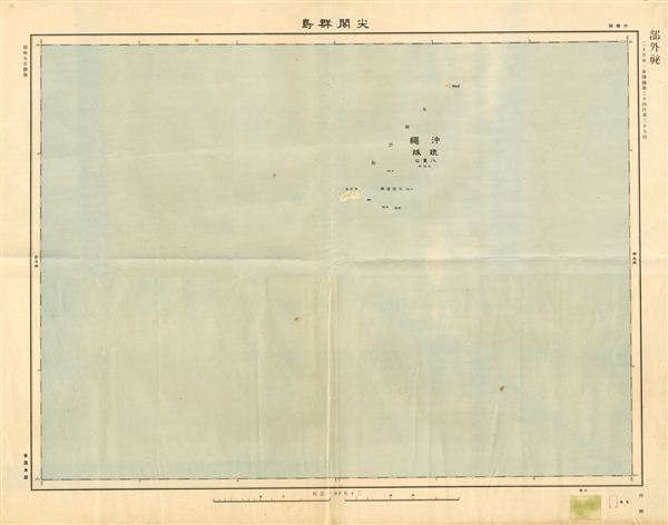
This is an extremely rare 1934 or Showa 9 Japanese map of the Senkaku or Diaoyutai, Diaoyu, Tiaoyutai or Pinnacle Islands. Currently the islands, located in the East China Sea, are a source of international tensions between Japan, China, and Taiwan, who each claim sovereignty. The islands have long been uninhabited and historically have been of little interest. The Japanese laid claim to the islands, along with numerous others, in 1895 and retained control until the end of World War II (1945). Following the war, the United States briefly administered them until, in accordance with the 1972 Okinawa Reversion Treaty, administration returned to the Japanese. Potential oil and gas reserves near the islands were identified in 1969. After the withdrawal of the United States, disputes arose between Japan, China, and Taiwan, all of whom claimed ownership of the islands. Since the islands had no significant value until the recent oil discoveries, and were for the most part uninhabited for centuries, most claims are semantic at best and tied to conflicting ancient geographies and travelogues, which are themselves dubious. The islands were briefly inhabited in 1970's when a Japanese businessman established a bonito (fish) processing plant on the island which eventually failed. China claims that it discovered and controlled the islands from as early as the 16th century. Taiwan's logic in claiming the islands follows China's.
Due to their size, remoteness and lack of resources, and the fact that the islands are uninhabited, no maps of the region were printed by either China or Taiwan until very recently. The Map Publication Co. of China released limited copies (3000) of the first edition map of the Diaoyutai Islands in October 2012, all of which sold out immediately. This early edition by the Japanese, who were years ahead in map publication, was issued in 1934 and is believed to be the most detailed map of the region before WWII and is the only copy available for sale. The map features a 'confidential' mark in the top right quadrant and another mark in the bottom left reads 'General Staff.' This is one of the maps in the set of 10 maps of the Okinawa Islands printed by the Japanese in 1934.
Due to their size, remoteness and lack of resources, and the fact that the islands are uninhabited, no maps of the region were printed by either China or Taiwan until very recently. The Map Publication Co. of China released limited copies (3000) of the first edition map of the Diaoyutai Islands in October 2012, all of which sold out immediately. This early edition by the Japanese, who were years ahead in map publication, was issued in 1934 and is believed to be the most detailed map of the region before WWII and is the only copy available for sale. The map features a 'confidential' mark in the top right quadrant and another mark in the bottom left reads 'General Staff.' This is one of the maps in the set of 10 maps of the Okinawa Islands printed by the Japanese in 1934.
Condition
Very good. Original fold lines.