
This item below is out of stock, but another example (left) is available. To view the available item, click "Details."
Details
1958 'Lefty' Burgess Pictorial Map of Seoul, Korea
$3,200.00
1958 'Lefty' Burgess Pictorial Map of Seoul, Korea
SeoulKorea-burgess-1958$1,375.00

Title
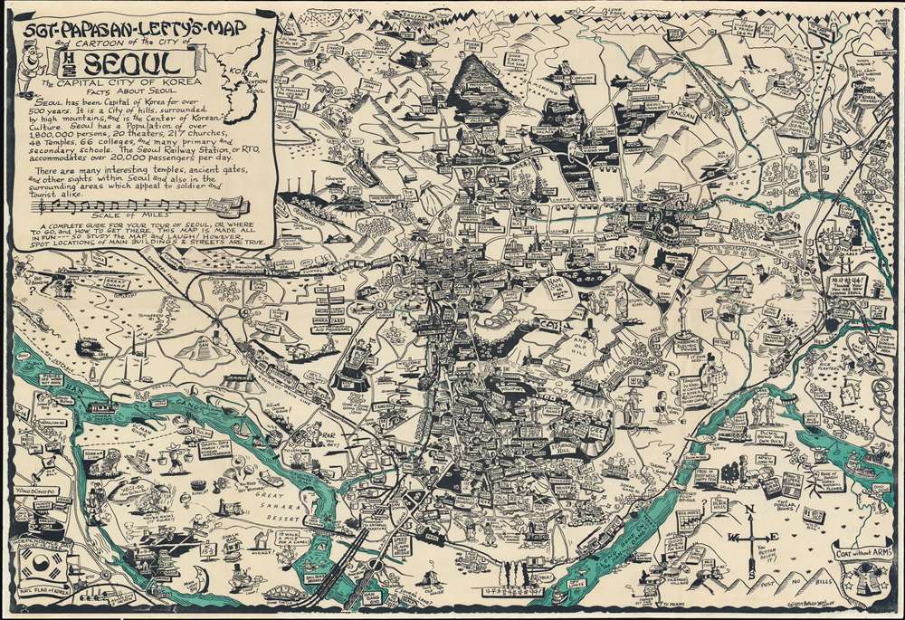
Sgt-Papasan-Lefty's-Map and Cartoon of the City of Seoul the Capital City of Korea.
1958 (dated) 20.75 x 30.5 in (52.705 x 77.47 cm)
1958 (dated) 20.75 x 30.5 in (52.705 x 77.47 cm)
Description
One of only two known surviving examples of Byrel W. Burgess's magnificent 1958 pictorial map of Seoul, Korea. Encompassing the heart of modern-day Seoul, the map humorously captures the ephemeral post-Korean War experience of American soldiers stationed there. Truly one of the great mid-century pictorial maps, following in the spirit of Frank Dorn (with whom Burgess served in the World War II China-Burma Theater), comic vignettes populate the map. These vignettes collectively highlight not only foreign-service military life, but also the exponential rise of American political and military influence between World War II (1939 -1945) and the Vietnam War (1955 - 1975).
The map is rife with cartoonish humorous elements designed to appeal to the American soldier in Seoul. Among them are nods to home - Texas appears prominently in the upper right. There are also signs to American cities: 'Frisco, Chicago, Detroit, and New Orleans, etc. But, the map is not intended to be purely humorous, as noted,
Useful and Funny
Coverage focuses on the center of modern Seoul, encompassing from Mapo-gu (마포구) to Yeouido (여의도). Itaewon (이태원) and the Gyongseong Station appear at center. The Han River (Hang Gang) flows along the bottom, while the Gyeongbok (Kyong Bok) and Changdeok (Chang Dok) Palaces, as well as the President's House and Mt. Bugaksan (Pugak San) are at top center. The large American military and airbase, then home to some 40,000 soldiers, appears at the lower left.The map is rife with cartoonish humorous elements designed to appeal to the American soldier in Seoul. Among them are nods to home - Texas appears prominently in the upper right. There are also signs to American cities: 'Frisco, Chicago, Detroit, and New Orleans, etc. But, the map is not intended to be purely humorous, as noted,
A complete guide for your tour of Seoul, or where to go, and How to get there. This map is made all in fun --- so study the map, and Laugh! However, spot locations of main buildings and streets are true.
Publication History and Census
The map was drawn and designed by Byrel William Burgess in 1958. It was printed in Seoul by the Samyung Printing Co. We have been unable to trace Samyung Printing. This map is rare, with only 2 examples known, including the present map. Both are in private hands. We find no references to the map in any institutional collections.Cartographer
Byrel William Burgess (April 5, 1914 - March 21, 1983), also known as 'Lefty' and 'Sgt. Crow' was an American career military engineer, as well as a comic and illustrator. Burgess was born in Owosso, Michigan. In 1938 he was living in Flint, Michigan, where he married Evelyn Anderson and worked as a sign painter for the Works Progress Administration (WPA). He may have had as much as 1 years of college before entering the military. There is a great deal of confusion regarding the dates of his military service, as he seems to have repeatedly entered and left the army, but in general, he was consistently in the U.S. Army Engineering Corps from 1941 to 1962 and attained the rank of Master Sargent. In 1943, he was called to active service to fight World War II (1939 - 1945). He served in Burma and China under General 'Vinegar Joe' Stilwell (1883 - 1946). During his service, he may have met and been inspired by fellow pictorial mapmaker Frank Dorn (1901 - 1981), who also served under Stilwell. His first map, made around 1945, illustrated the city of Chongqing, China, where he was stationed on a covert base at the end of World War II. After the war, he was transferred to London, issuing a pictorial map of that city in 1951. Then to Frankfurt, where he issued his most popular and common map, the 1954 Sgt. G.I. Crows' Eye View of Frankfurt AM and PM, Germany. It is not clear if Burgess served in the Korean War (1950 - 1953), but he was in Seoul in 1957, when he he issued Sgt. Papasan Lefty's Map and Cartoon of the City of Seoul, with a Korean publisher. Around 1960, Burgess was in San Francisco, where in October, he filed copyrights for two maps, A Crow's Eye View of Fisherman's Wharf, Telegraph Hill and part of the Embarcadero and Nite Owl's Map of Chinatown and Nite Club Land. These may never have been published as there are no known examples. Burgess then relocated to San Leandro, where he contributed cartoons to Oak Leaf, the in-house publication of the Naval Regional Medical Center of Oakland. He then lived in Yountville, Napa. He was buried in the San Francisco National Cemetery. Of his several maps, only the map of Frankfurt is obtainable. His map of Seoul is known in only 2 surviving examples. His other work is known only from secondary sources, such as copyright filings and articles. As a pictorial cartographer, his work is significant and unique in capturing U.S. foreign military life at ephemeral historical moments. More by this mapmaker...
Condition
Very good. Slight wear on old fold lines.