1718 Matthias Seutter map of the Kingdom of Serbia (First State)
Serbia-seutter-1718$950.00
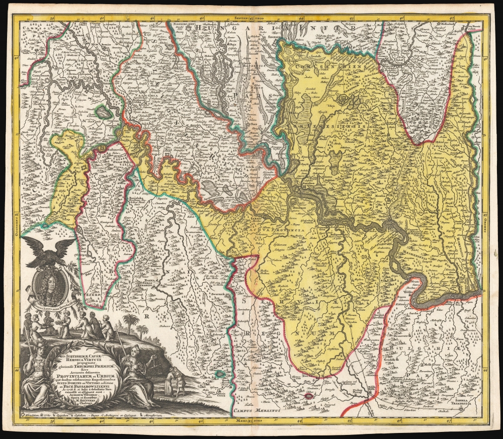

Title
Iustissimae causae heroica virtute propugnatae gloriosiss. Triumphi Praemium, sive accurata delineatio Provinciarum et Urbium quae duabus celeberrimis expeditionibus Iusto Domino ac Victori restitutae et Pace Passarowiziensi : A° 1718 d. 21 Julii a debellatis Turc. concessae et assignatae sunt.
1718 (dated) 19.5 x 22.75 in (49.53 x 57.785 cm) 1 : 590000
1718 (dated) 19.5 x 22.75 in (49.53 x 57.785 cm) 1 : 590000
Description
This is a beautiful, first state example of Matthias Seutter's 1718 map of Serbia, Timisoara, and parts of modern-day Croatia, Bosnia, and Bulgaria, showing these lands after they passed to the Austrian Empire from the Ottoman Turks following the July 22, 1718, Treaty of Passarowitz.
The treaty gave Austria the area of present-day Serbia, and allowed them to establish the Kingdom of Serbia as a crown land. Austrian control only lasted 21 years, until the Turkish victories of the Austro-Russian-Turkish war of 1735-1739 and the 1739 Treaty of Belgrade.
A Closer Look
The map covers the juncture of the Danube, Tisza, and Sava Rivers. Centered on Belgrade, coverage spans from Karlova in modern-day Croatia in the northwest, to Sofia, Bulgaria in the southeast. The Olt River in Romania forms the eastern limit and part of Hungary appears at the north limit. Mountains, forests, and wetlands are depicted pictorially. The map delineates roads, fortifications, cities, villages, and monasteries. In addition to contemporary features, Seutter includes the ruins of Trajan's Road along the Olt River. The most prominent feature, set apart with a deep yellow wash color, is the region of Timisoara and northern Serbia which the Ottoman Empire surrendered under the 1718 treaty of Passarowitz.The Peace of Passarowitz
Between 1714 and 1718, the Ottoman Empire won victories against Venice, but during the Austro-Turkish War of 1716-1718, the Austrian Field Marshal Prince Eugene of Savoy defeated them at the battle of Petrovaradin and Siege of Belgrade. As a result, a treaty was signed at Passarowitz (now part of Serbia.) As is implied in this map's ebullient cartouche, the treaty was viewed as an extraordinary success. The treaty established Habsburg control of the Banat of Temeswar, western Wallachia, northern Serbia (including Belgrade), and the northern part of Bosnia. In addition, the treaty permitted Habsburg merchants access to Ottoman territory, and removed restrictions placed by the Turks on Catholic priests in their domains. The treaty was less favorable to Venice, who lost Morea, Crete, the islands of Aegina and Tinos, and several inland cities.The treaty gave Austria the area of present-day Serbia, and allowed them to establish the Kingdom of Serbia as a crown land. Austrian control only lasted 21 years, until the Turkish victories of the Austro-Russian-Turkish war of 1735-1739 and the 1739 Treaty of Belgrade.
The Cartouche
The lower left corner is embellished with a superb cartouche, celebrating the Austrian victory. The title is not subtle:A just cause gloriously championed by heroic valor. The Prize of Triumph, or an Exact Delineation of the Provinces and Cities Restored to the Just Lord and Victor by the Two Famous Campaigns, and by the Peace of Passarowitz. Anno 1718 July 21, from the defeated Turks.The cartouche is flanked by the seated figures of Victory and Justice personified. It is surmounted with the portrait of the illustrious Prince Eugene of Savoy, the most famous military commander of his day, whose victories at Petrovaradin in 1716 and the Siege of Belgrade in 1717 forced the Ottoman Empire to the table. Kneeling Turkish supplicants present offerings to the portrait of the Prince, which bears the motto 'Victrici Lauro mitis succedit Oliva' [The gentle olive succeeds the victorious laurel]. To the right of the cartouche is a remarkable conciliatory note, apropos to the gentle olive: a man in European garb, with a resplendent wig, embraces a turbaned man with an Ottoman robe, emphasizing hopes for peace.
Publication History and Census
This map was engraved as early as late 1718, but no later than 1720 for inclusion in Seutter's Atlas geographicus. We have identified two states: this one, and another in which Seutter's title 'Chalcogr.' has been replaced with the initials of his latter title as Imperial Geographer. This second state appears as early as 1730. The map is scarce, with only separate examples listed in OCLC by the British Library, the Bibliothèque National de France, and Yale's Beinecke Library, but does still appear on the market from time to time.Cartographer
Matthäus Seutter (1678 - 1757) was one of the most important and prolific German map publishers of the 18th century. Seutter was born the son of a goldsmith but apprenticed as a brewer. Apparently uninspired by the beer business, Seutter abandoned his apprenticeship and moved to Nuremberg where he apprenticed as an engraver under the tutelage of the prominent J. B. Homann. Sometime in the early 1700s Seutter left Homann to return to Augsburg, where he worked for the prominent art publisher Jeremiad Wolff (1663 - 1724), for whom he engraved maps and other prints. Sometime around 1717 he established his own independent cartographic publishing firm in Augsburg. Though he struggled in the early years of his independence, Seutter's engraving skill and commitment to diversified map production eventually attracted a substantial following. Most of Seutter's maps are heavily based upon, if not copies of, earlier work done by the Homann and De L'Isle firms. Nonetheless, by 1731/32 Seutter was one of the most prolific publishers of his time and was honored by the German Emperor Karl VI who gave him the title of Imperial Geographer, after which most subsequent maps included the Avec Privilege designation. Seutter continued to publish until his death, at the height of his career, in 1757. Seutter had two engraver sons, Georg Matthäus Seutter (1710 - 173?) and Albrecht Carl Seutter (1722 - 1762). Georg Matthäus quit the business and relocated to Woehrdt in 1729 (and probably died shortly thereafter), leaving the family inheritance to his wastrel brother Albrecht Carl Seutter, who did little to advance the firm until in own death in 1762. Following Albrecht's death, the firm was divided between the established Johann Michael Probst (1727 - 1776) firm and the emerging firm of Tobias Conrad Lotter. Lotter, Matthäus Seutter's son-in-law, was a master engraver and worked tirelessly on behalf of the Suetter firm. It is Lotter, who would eventually become one of the most prominent cartographers of his day, and his descendants, who are generally regarded as the true successors to Matthäus Seutter. (Ritter, M. Seutter, Probst and Lotter: An Eighteenth-Century Map Publishing House in Germany., "Imago Mundi", Vol. 53, (2001), pp. 130-135.) More by this mapmaker...
Source
Seutter, M., Atlas geographicus, oder Accurate Vortsellung der ganzen Welt..., (Augsburg: Seutter) 1720.
Condition
Very good. Toning along centerfold, else excellent with a bold strike and rich original color.
References
OCLC 495042481. Rumsey 9753.081 (Second state).