This item has been sold, but you can get on the Waitlist to be notified if another example becomes available, or purchase a digital scan.
1880 Persian Variant on Fred Rose's Serio Comic Map of Europe (Octopus Map)
SerioComicMapPersian2-fredrose-1880$2,000.00

Title
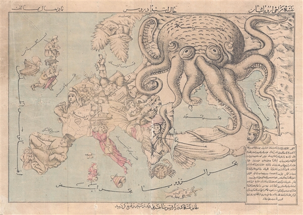
Comic Map of Europe. / نقشه طنز از اروپا
1880 (undated) 15 x 22 in (38.1 x 55.88 cm) 1 : 9000000
1880 (undated) 15 x 22 in (38.1 x 55.88 cm) 1 : 9000000
Description
A very rare c. 1880 Persian version of Englishman Fred Rose's iconic 1877 Serio Comic War Map, in which expansionist Imperial Russia is analogized as a menacing grasping octopus. Iranians at this time were beset by incursions from both Western Europe, in terms of increased English activity in southwestern Iran, and Russian political penetration in the form of strong inter-dependent alliances with the Qajar elite. The Qajar also borrowed substantially from both England and Russia, creating a deep network of financial ties. This was issued to illustrate and satirize conflicting perspectives for the educated Iranian public.
The map illustrates Rose's response to the Balkan Crises of 1877, wherein British interests were perceived to be under threat from the expansionistic zeal of the Russian Tsar.
In Rose's own words:
Fortunately there is textual description in Farsi to make all clear:
To be fair, although Rose popularized the convention of representing the Russia as a menacing octopus, it was in fact the Dutchman J. J. Van Brederode in 1870, who produced the first version of this map, the Humoristische-oorlogskaart. The convention of representing Russia as an octopus afterwards became extremely popular and was adopted by other caricaturists in Japan, Iran (as here), and elsewhere.
Our research suggests that this is one of only 2 known examples, with no other examples in evidence in either public or private collections. A once in a lifetime discovery.
The map illustrates Rose's response to the Balkan Crises of 1877, wherein British interests were perceived to be under threat from the expansionistic zeal of the Russian Tsar.
In Rose's own words:
The Octopus (Russia, the great glutton) no longer thinks about the wounds received during the Crimean War, and advances its armies in all directions. After having stemmed the Turk’s advance, the Russian marches forward, hoping to crush Turkey like he did with Poland. It seems Greece is also desirous to occupy and exhaust Turkey from another direction. Hungary is restrained only by its sister Austria from attacking Russia. France, still smarting from its recent defeat, is studiously inspecting its arsenal. Germany is observing France’s movements, and is prepared for all eventualities. Great Britain and Ireland are carefully monitoring the situation, and are prepared to prevent Russia from imposing itself on Turkey, or interfering in the Suez. Spain is taking a much-needed nap. Italy is toying with the Pope, while the rich King of the Belgians is securing his treasure. Denmark may have a small flag, but it has reasons to be proud.After reading Rose's description above, as printed on the first 1877 version of the map, published by Bacon, the careful observe will note several difference in this, our Persian variant. France, which in Rose's version, is Marshal MacMahon pointing a mitrailleuse towards Germany, is here a monk holding a scroll on which is a heart and text, which reads, in roughly translation from Farsi, 'Paris is the heart of the world and everyone wishes to be there' - suggestive of a strong Iranian affinity towards France. This somewhat undermines' Germany's position, which in the Rose map has its attention on France, but here, looks eastward towards Russia. Norway in Sweden, which Rose largely ignores, are here represented as happy sleeping babes. Sicily, which Rose drew as three wine barrels, here takes on a form that is rather hard to identify.
Fortunately there is textual description in Farsi to make all clear:
- England: in a hurry to not be left out.
- Spain: on account of keeping its power does not change anything and does nothing.
- Portugal: Always keeps up his appearances.
- France: all the world's wishes.
- Switzerland: An old wooden home who the wolves respect.
- Italy: Slipping everywhere.
- Sweden and Norway: they are as deeply asleep as they are not ready to do anything.
- Denmark: Keeps the flag of the seas.
- Finland: Seems like an old and broken mill.
- Belgium: The god of gold, silver, wealth and parties.
- Germany: Just watching his neighbor but doesn’t know what to do.
- Austria: Is busy with keeping Hungary back, but Hungary wants to fight.
- Greece: Is a marine animal that wants to come to land.
- Ottoman Empire: Is cut in two parts in the claws of an old animal (Russia).
- Russia: Is stretching his tentacles everywhere despite that some could cut them off, like Crimea and Japan.
- Iran : Is merely looking at the world with no benefit to is watching, (we) hope to wake up and act.
To be fair, although Rose popularized the convention of representing the Russia as a menacing octopus, it was in fact the Dutchman J. J. Van Brederode in 1870, who produced the first version of this map, the Humoristische-oorlogskaart. The convention of representing Russia as an octopus afterwards became extremely popular and was adopted by other caricaturists in Japan, Iran (as here), and elsewhere.
Our research suggests that this is one of only 2 known examples, with no other examples in evidence in either public or private collections. A once in a lifetime discovery.
Cartographer
Frederic William Rose (November 12, 1849 - January 3, 1915) was a politically conservative British satirist and caricature artist active in the late 19th century. There has been considerable debate regarding Rose's actual identity, due not to any attempt at secrecy, but rather at the commonality of the name. Nonetheless, recently book dealers Laurence Worms and Roderick Barron unearthed a great deal of new information about Rose and, apparently, we can anticipate an upcoming book. According to Worms, Rose was born to a well to do Paddington family of Scottish descent, the son of Major Hugo Monroe St. Vincent Rose of Glastullich and Frances Walrond Roberts. He was appointed as a clerk in the Legacy Duty office at Somerset House - where he was employed, in various positions, for the remainder of his working days. Rose married Catherine Rose Gilchrist and moved to London, where the Rose family lived at 9 Kensington Crescent before, in 1873, relocating to 4 Cromwell Crescent, where they remained. Rose traveled extensively throughout Europe and in 1885 published Notes on a Tour in Spain. In 1891 he divorced his wife on the grounds that she committed adultery - a rather humiliating and uncommon claim at the time. He wrote several other books and subsequently lost two of his sons in World War I. He died in London in 1915. In cartographic circles, Rose is best known for popularizing the caricature map in Europe. His most famous and influential work, while copied from Dutchman J. J. Van Brederode, is the 'Serio-Comic War Map', which represents late 18th century Russia as a grasping Octopus. Nonetheless, he also issued several other maps including another map of Europe entitled 'Angling in Troubled Waters' and variant of the Octopus map entitled 'John Bull and his Friends'. A less well known Rose map focuses on the British Isles and satirizes the 1880 Gladstone Government. More by this mapmaker...
Condition
Average. Map exhibits fading, creasing, a few repaird splits, and minor areas of loss. Backed on archival tissue.