1685 François Jollain View Map of Seville (Sevilla), Spain
Seville-jollain-1685$2,000.00

Title
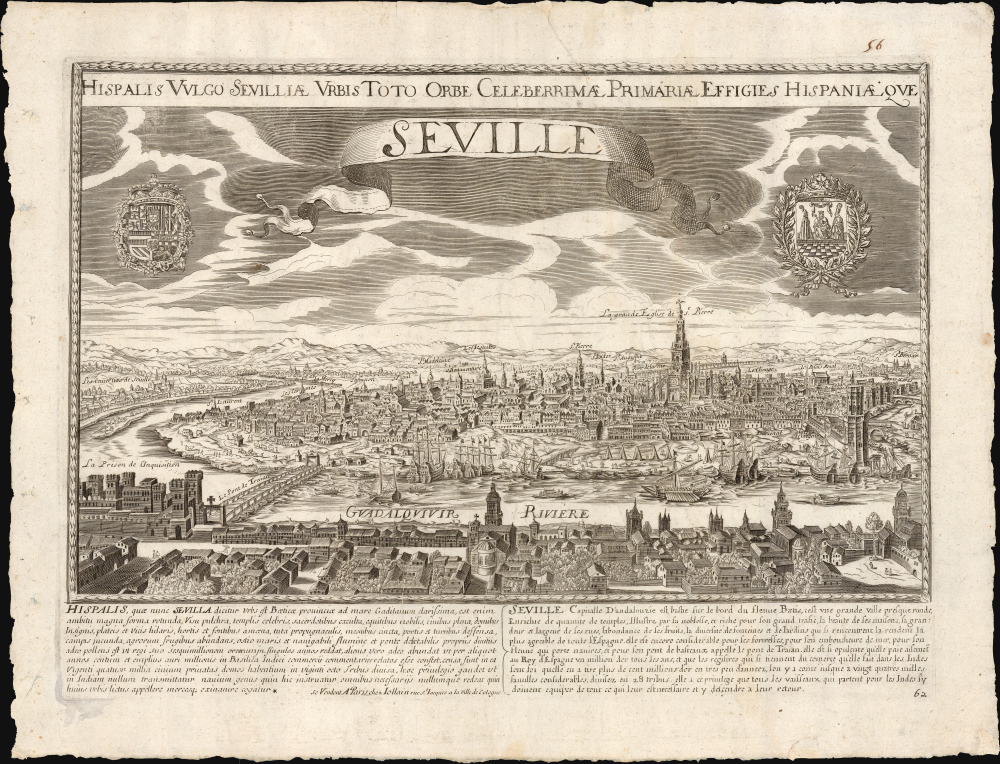
Hispalis Vulgo Sevilliae Urbis Toto Orbe Celeberrimae Primariae Effigies Hispaniae Que Seville.
1685 (undated) 15.25 x 20.75 in (38.735 x 52.705 cm)
1685 (undated) 15.25 x 20.75 in (38.735 x 52.705 cm)
Description
This is a rare, separately-issued c. 1685 François Jollain panoramic map of the Spanish city of Seville or Sevilla. It is an expanded version of the 1638 Merian view, here presented on a much larger scale.
A Closer Look
The view looks east on the city from a point overlooking the west bank of the Guadalquivir River. In the foreground to the left is the Castle of San Jorge, the headquarters of the Spanish Inquisition. The Triana Bridge (in its earlier form as a pontoon bridge) spans the river. Downstream, sailing ships line the shore. The city skyline bristles with church spires, many of which are named. A banner across the top names the city and is flanked by the armorial crests of Spain and Seville, respectively. At the bottom is a description of the city in both Latin and French.Historical Context
In the 17th century, Seville was one of Spain’s most important and cosmopolitan cities, serving as a vital hub for trade with the Americas under the Spanish Empire and, more darkly, as a major center of the Inquisition. The city thrived economically and culturally due to its monopoly over transatlantic commerce, administered through the Casa de la Contratación (House of Trade). Lavish displays of wealth funded magnificent Baroque architecture and supported a flourishing artistic scene, epitomized by painters such as Diego Velázquez and Bartolomé Esteban Murillo. However, Seville also faced challenges, including devastating plagues, flooding from the Guadalquivir River, and growing competition from Cádiz, which eventually supplanted it as the principal port for American trade by the end of the century.Publication History and Census
This view was engraved by Chez Jollain (either François or one of his sons) and separately published. The firm produced a series of views in this format, dated as early as 1670 and as late as 1692. Jollain's Seville is not cataloged in any institutional collection, and we do not see any published price records for the map over the past 40 years.CartographerS
François Jollain the Elder (c. 1641 - April 18, 1704) was a French engraver and publisher based in Paris. He was the son of Gérard Jollain, the founder of Chez Jollain, a long-lived publisher of engravings in Paris. While producing many maps and views, these seem to have been mostly separately issued; we do not see a dedicated Jollain atlas or city book. The firm's work was broad, extending to sheet music. (Jollain produced the first French engraving of music for the harpsichord, for example.) François was well regarded for his portrait work, in particular. Chez Jollain persisted into the 18th century: Jacques Jollain, François-Gérard Jollain, and Gérard Jollain the younger would continue as late as 1719. More by this mapmaker...
Matthäus Merian (September 22, 1593 - June 19, 1650), sometimes referred to as 'the Elder' to distinguish from his son, was an important Swiss engraver and cartographer active in the early to mid 17th century. Merian was born in Basel and studied engraving in the centers of Zurich, Strasbourg, Nancy and Paris. In time Merian was drawn to the publishing mecca of Frankfurt, where he met Johann Theodor de Bry, son of the famed publisher Theodor de Bry (1528 - 1598) . Merian and De Bry produced a number of important joint works and, in 1617, Merian married De Bry's daughter Maria Magdalena. In 1623 De Bry died and Merian inherited the family firm. Merian continued to publish under the De Bry's name until 1626. Around this time, Merian became a citizen of Frankfurt as such could legally work as an independent publisher. The De Bry name is therefore dropped from all of Merian's subsequent work. Of this corpus, which is substantial, Merian is best known for his finely engraved and highly detailed town plans and city views. Merian is considered one of the grand masters of the city view and a pioneer of the axonometric projection. Merian died in 1650 following several years of illness. He was succeeded in the publishing business by his two sons, Matthäus (1621 - 1687) and Caspar (1627 - 1686), who published his great works, the Topographia and Theatrum Europeaum, under the designation Merian Erben (Merian Heirs). Merian's daughter, Anna Maria Sibylla Merian, became an important naturalist and illustrator. Today the German Travel Magazine Merian is named after the famous engraver. Learn More...
Condition
Very good. Mended tear to upper margin just entereing border. Thread holes in left margin. Else excellent with deckled edges.