This item has been sold, but you can get on the Waitlist to be notified if another example becomes available, or purchase a digital scan.
1861 Becker Map of Shanghai, China
Shanghai-becker-1861$750.00

Title
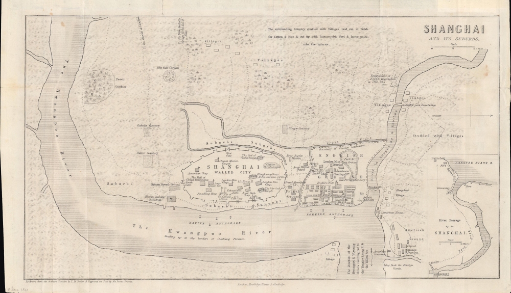
Shanghai and Its Suburbs.
1861 (undated) 8 x 14.25 in (20.32 x 36.195 cm) 1 : 16500
1861 (undated) 8 x 14.25 in (20.32 x 36.195 cm) 1 : 16500
Description
An important early map of Shanghai in the Treaty Port Era (1842 - 1943), this is L. M. Becker's 1861 overview of the city which appeared in Rev. William C. Milne's book Life in China. It is considered one of the earliest western maps of Shanghai, dating to the period just prior to the merging of British and American concessions ('grounds') to form the International Settlement.
Given Milne's background as a missionary, special attention is paid to churches and mission houses. Chinese temples within the walled city are also noted. Paths at top lead to destinations further to the west, including the Longhua Pagoda and the Catholic compound at Xujiahui (Si-ka-wei). At right is Hongkou (Hung-kow), where Americans predominated and where, in later decades, thousands of Japanese would reside. The village at bottom, across the Huangpu (Hwangpoo) from the main part of the city, is Lujiazui, the most heavily developed portion of Pudong now dominated by skyscrapers.
However, the wider question of the Taiping, now based in nearby Nanjing, had not disappeared. In 1860, Taiping forces attacked and briefly occupied the walled city of Shanghai. Over the next two years, the two opposing sides fought throughout the surrounding region, with Qing forces, backed by foreign powers and the 'Ever Victorious Army,' a foreign-led group of mercenaries and local recruits, eventually staving off the threat to Shanghai. Still, it was not until 1864 that the Qing recaptured Nanjing, the penultimate battle of the war with the Taiping.
A Closer Look
Oriented towards the west, the map takes in the walled 'Chinese city' of Shanghai as well as the foreign settlements nearby and the city's hinterland. The foreign 'grounds' or concessions are clearly demarcated; in 1863, the British and American communities merged to form the International Settlement, while the French Concession remained separate. This map also makes clear that the territory of the foreign concessions, initially not intended to be distinct from Chinese territory, evolved from their bases along the riverfront (Bund); in time, the foreign concessions would extend well beyond the scope of this map and develop their own administrative bodies, police forces, and courts.Given Milne's background as a missionary, special attention is paid to churches and mission houses. Chinese temples within the walled city are also noted. Paths at top lead to destinations further to the west, including the Longhua Pagoda and the Catholic compound at Xujiahui (Si-ka-wei). At right is Hongkou (Hung-kow), where Americans predominated and where, in later decades, thousands of Japanese would reside. The village at bottom, across the Huangpu (Hwangpoo) from the main part of the city, is Lujiazui, the most heavily developed portion of Pudong now dominated by skyscrapers.
Building the Iron Road to the Sea
An inset at bottom-right displays the region between Shanghai and the mouth of the Yangtzee River near Wusong (Woosung). The forts along the coast were an important objective during the First Opium War; after capturing the forts, the British moved on to occupy Shanghai, which ultimately to its being designated one of the first treaty ports. In 1876, China's first railway opened, connecting Shanghai to Wusong. It was built without the approval of Qing officials and only operated for a year before being purchased and dismantled by Viceroy Shen Baozhen, an act often seen as emblematic of Qing obstinance, though the surreptitious means used by the railway's financiers were more likely the reason for Shen's drastic response.No Small Task
A note about the 'encampment of 10,000 imperialists in 1853, '54' does not refer to foreign imperialists but to Qing imperial forces, sent to Shanghai to suppress the Small Swords Uprising, which had overtaken the walled city in September 1853 and aligned itself with the Taiping Heavenly Kingdom, another, much larger rebel force in southern China. The nascent foreign community was divided on how to respond to the uprising; the French sided strongly with the Qing, even committing troops to aid the Qing forces besieging the walled city, while the British and Americans were more circumspect. Eventually, though, they came to tepidly support the Qing, who recaptured the walled city in February 1855.However, the wider question of the Taiping, now based in nearby Nanjing, had not disappeared. In 1860, Taiping forces attacked and briefly occupied the walled city of Shanghai. Over the next two years, the two opposing sides fought throughout the surrounding region, with Qing forces, backed by foreign powers and the 'Ever Victorious Army,' a foreign-led group of mercenaries and local recruits, eventually staving off the threat to Shanghai. Still, it was not until 1864 that the Qing recaptured Nanjing, the penultimate battle of the war with the Taiping.
Publication History and Census
This map was engraved by L. M. Becker and appeared in Rev. William C. Milne's book Life in China, which was published in three editions (1857, 1858, and 1861). This edition of the map is not independently cataloged with any institution; the University of Chicago and the Hong Kong University of Science and Technology hold the 1857 edition, and the Australian National University holds an example dated c. 1853, likely also from the 1857 edition of the book. Regardless of edition, the book in its entirety is only held by the National Library of Australia (noted as missing one map), Hong Kong University, and the School of African and Oriental Studies, University of London. An 1858 French translation is more widely distributed.Source
Milne, W., Life in China, (Londong: Routledge) 1861.
Condition
Good. Creasing along fold lines. Wear and uneven trim along edges.