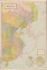
1932 Cross House Map of Shanghai, China
Shanghai-crosshouse-1932$1,900.00

Title
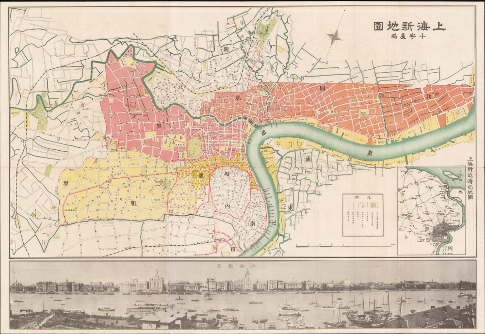
Shanghai New Map. / 上海新地圖
1932 (dated) 21.25 x 31 in (53.975 x 78.74 cm) 1 : 12000
1932 (dated) 21.25 x 31 in (53.975 x 78.74 cm) 1 : 12000
Description
A scarce March 5, 1932, map of Shanghai, China, issued by Osaka-based Cross-House publishing firm. The map was issued to illustrate the Shanghai Ceasefire Agreement (淞沪停战协定), a peace treaty between China and Japan that made Shanghai a demilitarized zone. It follows the January 28 Incident, also known as the Shanghai Incident (January 28 - March 3, 1932), a conflict in the Shanghai International Settlement between the Republic of China and the Empire of Japan.
Lining the Huangpu River, the Shanghai Bund has dozens of historical buildings that once housed important banks and trading housing from the United Kingdom, France, United States, Italy, Russia, Germany, Japan, the Netherlands, and Belgium, as well as the consulates of Russia and Britain, a newspaper, the Shanghai Club, and the Masonic Club. The Bund lies north of the old walled city of Shanghai and was initially a British settlement. A building boom at the end of the 19th century and the beginning of the 20th century led to the Bund becoming the major financial hub of East Asia. The former French Bund, east of the walled city, was formerly more a working harbor.
A Closer Look
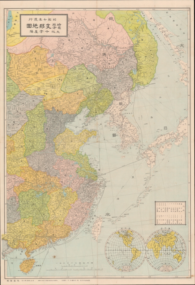
The map's focus centers on the concession regions, using color coding to distinguish between the British and American Concessions (red), the Japanese-controlled region (Orange), and the French Concession (Yellow). Along the bottom of the map, there is a dramatic view of the Bund - marking this map as part of a lineage of similar maps by Fusazo Sugie (杉江房造), although it is distinct and only stylistically related to the others. The verso (back) features a large map of China, Manchuria, and Korea - a region that would soon be embroiled in war.Shanghai Incident of 1932
The conflict of January 28th, 1932, also known as the Shanghai Incident or Shanghai War, was a precursor to the Second Sino-Japanese War (1937 - 1845), which would begin a few years later. Following several alleged attacks on Japanese nationals, the Japanese launched a blitzkrieg-style attack on Chinese Nationalist forces with the supposed intent of protecting Japanese civilians residing in the Hongkou District, an informal Japanese Concession within the International Settlement. The Chinese Nationalist troops concentrated in Zhabei to protect the strategically important Shanghai Railway Station, through which supplies and reinforcements could be readily delivered. The Chinese resistance proved stubborn, and both sides established perimeters along the Huangpu River. A similar perimeter was established to the south, along the Wusong River, to protect the British and French Concessions. Nonetheless, the Japanese pursued their attack, using gunboats on the Wusong River and Huangpu River to harry the Chinese. Ultimately, the two sides fought to a near standstill. On March 5th, the League of Nations forced the Japanese to sign a ceasefire, the Shanghai Ceasefire Agreement (淞沪停战协定), with China, turning Shanghai into a demilitarized zone.Shanghai International Settlement
The Shanghai International Settlement was created in 1863 when the British and American Shanghai enclaves merged. These concessions had been granted to England and the United States as part of the Unequal Treaties that followed the Opium Wars. From about 1854, the settlements were governed by the Shanghai Municipal Council, a British-dominated board of government officials and powerful merchants. The board issued restrictions limiting Chinese habitation on International Settlement territory and oversaw the construction of public services, including trams, a sewage system, highways, and port buildings. The International Settlement expanded several times in the late 19th century and early 20th century. In addition, they constructed and administered Extra-Settlement Roads into the surrounding country, which further allowed for informal expansion. It became an enclave of peace and prosperity when the Japanese invaded Shanghai in 1937, but this abruptly came to an end with the Japanese bombing of Pearl Harbor and the subsequent invasion of the International Settlement in 1941. After the war the International Settlement lands were returned to Chinese sovereignty.The Bund
The Bund is a waterfront area in central Shanghai. The name derives from the old German term, 'bund,' meaning embankment or causeway. Many Asian colonial cities supported a Bund, but none became more famous or iconic than the Shanghai Bund. The area centers on the section of Zhongshan Road within the former Shanghai International Settlement, which runs along the western bank of the Huangpu River, facing Pudong, in the eastern part of Huangpu District. The Bund usually refers to the buildings and wharves on this section of the road and some adjacent areas. It is one of the most famous tourist destinations in Shanghai and a designated historic zone.Lining the Huangpu River, the Shanghai Bund has dozens of historical buildings that once housed important banks and trading housing from the United Kingdom, France, United States, Italy, Russia, Germany, Japan, the Netherlands, and Belgium, as well as the consulates of Russia and Britain, a newspaper, the Shanghai Club, and the Masonic Club. The Bund lies north of the old walled city of Shanghai and was initially a British settlement. A building boom at the end of the 19th century and the beginning of the 20th century led to the Bund becoming the major financial hub of East Asia. The former French Bund, east of the walled city, was formerly more a working harbor.
Shanghai 1910 - 1932
The 1910s-20s were a golden age for Shanghai, at least in the Concessions. While China was ruled by Chiang Kai-shek, Shanghai was dominated by several consolidated foreign trade Concessions. Under the strict administrative control of the Concessions, the city became a cosmopolitan haven and center for global trade amid a sea of political unrest. The Concessions occupied what is today central Shanghai's most desirable land, hugging the Huangpu River and Wusong River (Suzhou Creek). These extraterritorial European, Japanese, and American enclaves had modern housing, fine roads, streetcars, elegant shops, clubs, and more. It was a place of excess, art, and extravagance, where fortunes could be made by the enterprising - and lost by the foolish. Moreover, lacking the moral constraints that limited social life in Europe and America, Shanghai became a nexus for the opium trade, sexual excess, gambling, and other vices. This ephemeral world came crashing down on January 28, 1932, when the 'Shanghai Incident' or 'January 28 Incident' pitted the Republic of China against the Empire of Japan. Responding to Chinese student protests against the Japanese occupation of Manchuria, the Japanese Navy bombarded Shanghai. Chiang Kai-shek sent the Chinese army in to defend the Shanghai students, threatening to escalate the conflict. The League of Nations, fearing all-out war, united to demand a ceasefire, which was signed. Nonetheless, most consider The January 28 incident to be the opening salvo of the Second Sino-Japanese War (1938 - 1945), which ultimately merged into World War II.Publication History and Census
This map was drawn by Katsura Todo (取藤勝藏) and published by the Cross House (十字屋編) firm in Osaka, Japan. As noted in the opening paragraph, this map stylistically resembles other similar maps issued both earlier and later by the prominent Japanese cartographer, Fusazo Sugie (杉江房造). It is, nonetheless, distinct, both cartographically, and with regard the Bund view, which is unique. It is rare and does not appear in Virtual Shanghai or other map archives. We are aware of no other confirmed examples.Cartographer
Cross House (十字屋編; fl. 1930 - 1945) was an Osaka based Japanese publishing house active in the first half of the 20th century. They published books and maps. More by this mapmaker...
Condition
Very good. Accompanied by original envelope. Map of China on verso. Wear on old fold lines.