
1932 Fine Printing Co. Map of Shanghai and Vicinity - Shanghai War of 1932

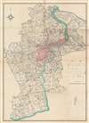
[Shanghai and Vicinity.]
Demilitarized concessions after the 1932 Shanghai War.
$950.00
Choose a Collection:
- Digital Map Information
- Suitable for large format printing
- File Size: 53.49 MB
- File Type: ZIP / TIFF
- ICC color profile embedded
- Delivered instantly via download link
This Item
Enquire
Demilitarized concessions after the 1932 Shanghai War.
This is a scarce 1932 (Showa 7) Japanese map printed for the Shanghai Textile Company by the Fine Printing (Seiko) Company. It illustrates the vicinity of Shanghai shortly after the Shanghai Incident of 1932, which destroyed part of the city and set off a refugee crisis, presaging even greater upheaval five years later.A Closer Look
The map was produced to illustrate the city's suburban region, and as such covers from the confluence of the Huangpu with the Yangtze to the sharp bend in the Huangpu in today's Minhang District. A legend on the right explains the symbols and illustrations used for roads, railways, piers, administrative boundaries, waterways, towns, villages, and other features. The Huangpu River runs through the center of the map, with the International Settlement and French Concession areas highlighted in pink - essentially forming a demilitarized zone in the wake of the January 28th Japanese attack on Shanghai. The map was adapted with overprinting to add additional detail, including hachuring that identifies high-density population zones in the Chinese quarter south of the French Concession (人家緻密地). Further coding identifies towns and villages of varying sizes. The map beautifully illustrates the elaborate canal system surrounding Shanghai, which functioned as a de facto highway system for regional trade and commerce.Shanghai Incident of 1932
The conflict of January 28, 1932, also known as the Shanghai Incident or Shanghai War, was a precursor to the Second Sino-Japanese War, which would begin a few years later. In the wake of the Japanese occupation of Manchuria on September 18, 1931, Chinese student protests and a boycott against Japanese goods spread throughout China. Following several alleged attacks on Japanese nationals, the Japanese launched a blitzkrieg-style attack on Chinese Nationalist forces with the supposed intent of protecting Japanese civilians residing in the Hongkou District, an informal Japanese Concession within the International Settlement. The Chinese Nationalist troops concentrated in Zhabei in order protect the strategically important Shanghai Railway Station, through which supplies and reinforcements could be readily delivered. The Chinese resistance proved stubborn, and both sides established perimeters along the Huangpu River. A similar perimeter was established to the south, along the Wusong River, to protect the British and French Concessions. The Japanese nonetheless pursued their attack, using gunboats on the Wusong River and Huangpu River to harry the Chinese. Ultimately, the two sides fought to a near standstill. In late February, the League of Nations forced both sides to sign a ceasefire, turning Shanghai into a demilitarized zone.Shanghai 1910 - 1932
The 1910s-20s were a golden age for Shanghai, at least in the Concessions. While China was ruled by Chiang Kai-shek (1887 - 1975), Shanghai was dominated by several consolidated foreign trade Concessions. Under the administrative control of the Concessions, the city became a cosmopolitan haven amid political unrest and a center for global trade and finance. The Concessions occupied what today is central Shanghai's most desirable land, hugging the Huangpu River and Wusong River (Suzhou Creek). These extraterritorial European, Japanese, and American enclaves had modern housing, fine roads, streetcars, elegant shops, clubs, and more. It was a place of excess, art, and extravagance, where fortunes could be made by the enterprising - and lost by the foolish. Moreover, lacking the moral constraints that limited social life in Europe and America, Shanghai became a nexus for the opium trade, sexual excess, gambling, and other vices. This ephemeral world came crashing down on January 28, 1932, when the 'Shanghai Incident' or 'January 28 Incident' changed everything.Shanghai International Settlement
The Shanghai International Settlement was created in 1863 when the British and American Shanghai enclaves merged. These concessions had been granted to England and the United States as part of the Unequal Treaties that followed the Opium Wars. From about 1854, the settlements were governed by the Shanghai Municipal Council, a British-dominated board of government officials and powerful merchants. The board issued restrictions limiting Chinese habitation on International Settlement territory and oversaw the construction of public services, including trams, a sewage system, highways, and port buildings. The International Settlement expanded several times in the late 19th and early 20th centuries. In addition, they constructed and administered Extra-Settlement Roads into the surrounding country, which further allowed for informal expansion. It became an enclave of peace and prosperity when the Japanese invaded Shanghai in 1932 and 1937, but this abruptly came to an end with the Japanese bombing of Pearl Harbor and subsequent invasion of the International Settlement in 1941. During the war, the International Settlement and the French Concession were returned to Chinese sovereignty to bolster the Wang Jingwei collaborationist government.Publication History and Census
This map was printed in 1932 by the Fine Printing Company (or Seiko Printing Company, 精版印刷株式會社), a local firm likely based in the Japanese area of the city in Hankou, for the Japanese-operated Shanghai Textile Company, Ltd. (上海紡織株式會社), also known by the abbreviation Shambō (上海, シャンボウ), a Mitsui subsidiary, recorded here as being based on Yangshupu Road (楊樹浦路) in Hankou.This map is rare and we have identified no other examples. It does not appear in the Virtual Shanghai archive. Further research into the map is generally stymied by the fact that the map has no title. We do note a similar map covering the area northeast of Shanghai, in the Virtual Shanghai Archive, but nothing matching the scope or size of the present map.
Cartographer
Fine Printing Co., Ltd. (精版印刷株式會社; 1931 - 1945) was a Japanese owned and operated printing concern based in Shanghai, No. 4 Qiqihar Road, during the pre-War (1932 - 1939) and World War II (1939 - 1945) eras. Further Details...
Condition
Very good. Some wear on old fold lines. Toning corresponding to original fold metric.