1928 Jen Feng She Tourist Map of Shanghai
Shanghai-jinfenshe-1928$950.00

Title
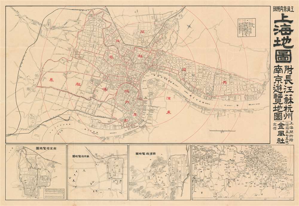
Map of Shanghai. / 上海地圖
1928 (undated) 21 x 30.5 in (53.34 x 77.47 cm)
1928 (undated) 21 x 30.5 in (53.34 x 77.47 cm)
Description
An extremely rare c. 1928 pre-war tourist map of Shanghai, China, issued in Shanghai by Jin Feng She (金鳳社). The map illustrates the core of Shanghai focused on the Foreign Concessions, the old Chinese Walled City, and the many business along the Hunagpu River. Ghosted dotted lines indicate streets under construction and are most commong in the International Settlement and in the periphery of the city. It extends westward to include the route of the Shanghai Hangchow Ningpo Railway. Electric tramways are highlighted with solid red lines. The dotted red lines illustrated the borders of the concessions. Fine dotted lines highlight railless electric trams.
Shanghai 1910 - 1932
The 1910s-20s were a golden age for Shanghai. While China was ruled by Chiang Kai-shek, Shanghai was dominated by several consolidated foreign trade Concessions. Under the strict administrative control of the Concessions, the city became a cosmopolitan haven in the midst of political unrest and a center for global trade and finance. The Concessions occupied what is today central Shanghai's most desirable land, hugging the Huangpu River and Wusong River (Suzhou Creek). These extraterritorial European, Japanese, and American enclaves had elegant housing, fine roads, streetcars, elegant shops, clubs, and more. It was a place of excess, art, and extravagance, where fortunes could be made by the enterprising - and lost by the foolish. Moreover, lacking the moral constrains that limited social life in Europe and America, Shanghai became nexus for the opium trade, sexual excess, gambling, and other vices. This ephemeral world come crashing down on January 28, 1932, when the Shanghai Incident or January 28 Incident pitted the Republic of China against the Empire of Japan. Responding to Chinese student protests against the Japanese occupation of Manchuria, the Japanese Navy bombarded Shanghai. Chiang Kai-shek sent the Chinese army in to defend the Shanghai students, threatening to escalate the conflict. The League of Nations, fearing all-out war, united to demand a ceasefire, which was signed. Nonetheless, most consider The January 28 incident to be the opening salvo of the Second Sino-Japanese War (1938 - 1945) which ultimately merged into World War II.Shanghai International Settlement
The Shanghai International settlement was created in 1863 when the British and American Shanghai enclaves merged. These concessions had been granted to England and the United States as part of the Unequal Treaties that followed the Opium Wars. From about 1854 the settlements were governed by the Shanghai Municipal Council, a British dominated board of government officials and powerful merchants. The board issued restrictions limiting Chinese habitation on International Settlement territory and oversaw the construction of public services, including Trams, a sewage system, highways, and port buildings. The International settlement expanded several times in the late 19th and early 20th century. It became an enclave of peace and prosperity when the Japanese invaded Shanghai in 1937 but this abruptly came to an end with the Japanese bombing of Pearl Harbor and subsequent invasion of the International Settlement in 1941. After the war the International Settlement lands were returned to Chinese sovereignty.Shanghai French Concession - 上海法租界
On April 6, 1849, Lin Kouei (麟桂), the Chinese governor of Shanghai, granted French Consul Charles de Montigny (1805 - 1868) a proclamation ceding extraterritoriality to France in order to establish a trading colony. The Concession initially occupied a narrow collar of land around the northern end of the Chinese City, south of the British settlement, an area of 66 hectares. It was subsequently expended several times. A further small strip of riverside land to the east of the Chinese City was added in 1861, to allow for the Quai de France, docks servicing shipping between China and France. Between 1899 and 1900 the French Concession further expanded, nearly doubling in size with new territory extending west of the original grant. It expanded again in 1914, reaching as far west as modern Huashan Lu (Avneue Haig). By the 1920s, the western part of the French Concession had become the most desirable residential area of Shanghai, popular both with foreign nationals and wealthy Chinese. The concession was mistakenly bombed during the chaotic 1937 Battle of Shangahi, fought between the National Revolutionary Army (NRA) of the Republic of China (ROC) and the Imperial Japanese Army (IJA). In 1943, the French Concession was handed over to the Japanese puppet Wang Jingwei Regime by Vichy France. The turnover was officially ratified after the war by the Sino-French Accord of February 1946, signed by the French Ambassador and Chiang Kai-shek. Today the French Concession, with its tree lined boulevards and French colonial architecture, remains Shanghai's most desirable neighborhood.Publication History and Census
We have found no evidence of this map or its publication. The Shanghai publishing house by Jin Feng She (金鳳社), was probably a Japanese-Chinese concern active during the pre-war period. It was located at (閔行路 575 号) Minhang Road, No. 575, in the Japanese part of the international Settlement. No other examples are known.Cartographer
Chojiro Shimazu (島津長治郎, fl. c. 1900 - 1927) was a Japanese publisher based in Shanghai, China. Chojiro arrived in China around 1900, establishing himself in the pharmaceutical business. He began publishing in 1912, founding Jin Feng She (金鳳社) press. Under his leadership, the press published several Japanese language guidebooks, maps, directories, and more. More by this mapmaker...
Condition
Very good. Minor wear on original fold lines, especially at fold intersections.