This item has been sold, but you can get on the Waitlist to be notified if another example becomes available, or purchase a digital scan.
1927 Sugie Fusazo First Edition Map of Shanghai w/ Bund Panorama
Shanghai-sugiefusazo-1927$925.00

Title
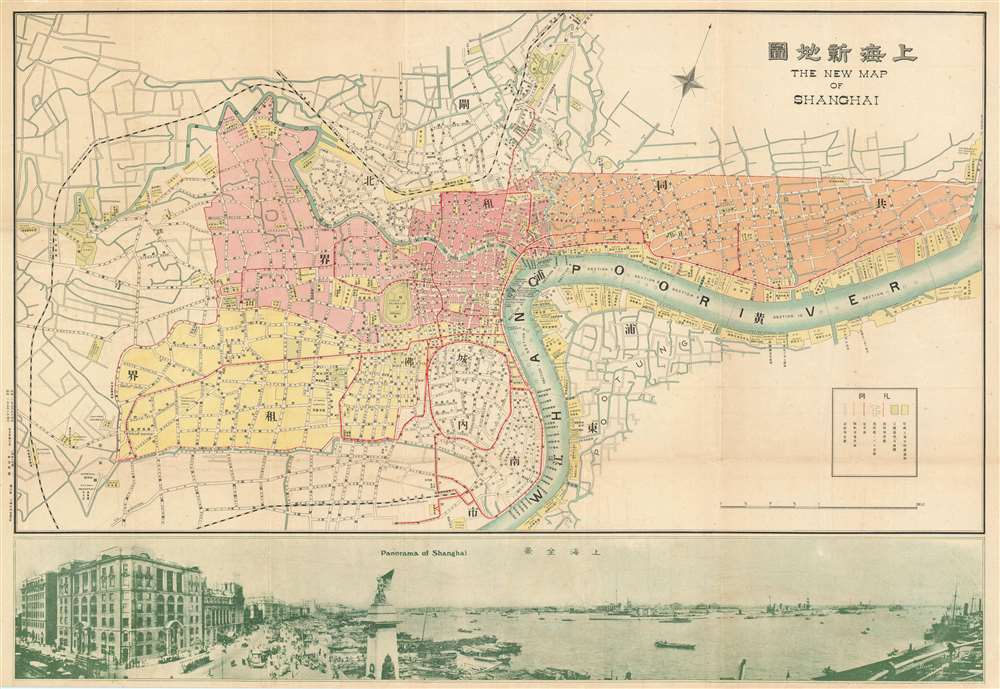
New Map of Shangahi. / 上海新地圖
1927 (dated) 21 x 30.5 in (53.34 x 77.47 cm) 1 : 21000
1927 (dated) 21 x 30.5 in (53.34 x 77.47 cm) 1 : 21000
Description
An extremely rare bi-lingual Chinese/English map of Shanghai, China, here in its first edition, issued by the Shanghai-Japanese cartographer Sugie Fusazō (杉江房造) in May of 1927, or Showa 2. This map was produced in the wake of the pro-Nationalist anti-Communist Shanghai Massacre of April 1927, considered the beginning of the Chinese Civil War (國共內戰; 1927 - 1945). This is also the first of Sugie Fusazō's maps to include a panorama of the city (more specifically the Bund), a convention that would be followed in some later editions of the map. The map focuses on the extraterritorial Foreign Concessions huddled around the confluence of the Hunagpu River (Whangpoo) and Soochow Creek (Suzhou). The Japanese area is highlighted in orange, the British in red, the American in Pink, and the large separate French Concession in Yellow. The map extends westward along the Extraterritorial Roads, also administered by the Concessions, as far as the Jessfield Road (Zhongshan) Toyoda Factory, precursor of the modern conglomerate Toyota.
Lining the Huangpu River, the Shanghai Bund has dozens of historical buildings that once housed important banks and trading houses from the United Kingdom, France, United States, Italy, Russia, Germany, Japan, Netherlands and Belgium, as well as the consulates of Russia and Britain, a newspaper, the Shanghai Club and the Masonic Club. The Bund lies north of the old walled city of Shanghai and was initially a British settlement. A building boom at the end of the 19th century and the beginning of the 20th century led to the Bund becoming the major financial hub of East Asia. The former French Bund, east of the walled city was formerly more a working harbor.
Shanghai Massacre of April 12, 1927
The Shanghai Massacre (四一二慘案) of April 12, 1927, known in China as the 'April 12 Purge' or 'April 12 Incident', was the violent suppression of the Communist Party of China (CPC) in Shanghai by Generalissimo Chiang Kai-shek and conservative factions in the Kuomintang Nationalist Party (KMT). Most of the violence was focused in the districts of Zhabei, Nanshi, and Pudong, while the concession areas illustrated here largely avoided conflict. By some estimates 5,000 - 10,000 Shanghai communist sympathizers were killed, but the official count is just 300. The unrest ultimately exacerbated tensions associated with the May 30th Movement and led directly to the Anti-communist Northern Expedition.Shanghai International Settlement
The Shanghai International settlement was created in 1863 when the British and American Shanghai enclaves merged. These concessions had been granted to England and the United States as part of the Unequal Treaties that followed the Opium Wars. From about 1854 the settlements were governed by the Shanghai Municipal Council, a British dominated board of government officials and powerful merchants. The board issued restrictions limiting Chinese habitation on International Settlement territory and oversaw the construction of public services, including trams, a sewage system, highways, and port buildings. The International Settlement expanded several times in the late 19th and early 20th century. In addition, they constructed and administered Extra-Settlement Roads into the surrounding country, which further allowed for informal expansion. It became an enclave of peace and prosperity when the Japanese invaded Shanghai in 1937 but this abruptly came to an end with the Japanese bombing of Pearl Harbor and subsequent invasion of the International Settlement in 1941. After the war the International Settlement lands were returned to Chinese sovereignty.The Bund
The Bund is a waterfront area in central Shanghai. The name is derived from the old German term, 'bund,' meaning simply embankment or causeway. Many Asian colonial cities supported a Bund, but none became more famous or iconic than the Shanghai Bund. The area centers on the section of Zhongshan Road within the former Shanghai International Settlement, which runs along the western bank of the Huangpu River, facing Pudong, in the eastern part of Huangpu District. The Bund usually refers to the buildings and wharves on this section of the road, as well as some adjacent area. It is one of the most famous tourist destinations in Shanghai and a designated historic zone.Lining the Huangpu River, the Shanghai Bund has dozens of historical buildings that once housed important banks and trading houses from the United Kingdom, France, United States, Italy, Russia, Germany, Japan, Netherlands and Belgium, as well as the consulates of Russia and Britain, a newspaper, the Shanghai Club and the Masonic Club. The Bund lies north of the old walled city of Shanghai and was initially a British settlement. A building boom at the end of the 19th century and the beginning of the 20th century led to the Bund becoming the major financial hub of East Asia. The former French Bund, east of the walled city was formerly more a working harbor.
Shanghai French Concession - 上海法租界
On April 6, 1849, Lin Kouei (麟桂), the Chinese governor of Shanghai, granted French Consul Charles de Montigny (1805 - 1868) a proclamation ceding extraterritoriality to France in order to establish a trading colony. The Concession initially occupied a narrow collar of land around the northern end of the Chinese City, south of the British settlement, an area of 66 hectares. It was subsequently expended several times. A further small strip of riverside land to the east of the Chinese City was added in 1861, to allow for the Quai de France, docks servicing shipping between China and France. Between 1899 and 1900 the French Concession further expanded, nearly doubling in size with new territory extending west of the original grant. It expanded again in 1914, reaching as far west as modern Huashan Lu (Avneue Haig). By the 1920s, the western part of the French Concession had become the most desirable residential area of Shanghai, popular both with foreign nationals and wealthy Chinese. The concession was mistakenly bombed during the chaotic 1937 Battle of Shanghai, fought between the National Revolutionary Army (NRA) of the Republic of China (ROC) and the Imperial Japanese Army (IJA). In 1943, the French Concession was handed over to the Japanese puppet Wang Jingwei Regime by Vichy France. The turnover was officially ratified after the war by the Sino-French Accord of February 1946, signed by the French Ambassador and Chiang Kai-shek. Today the French Concession, with its tree lined boulevards and French colonial architecture, remains Shanghai's most desirable neighborhood.Shanghai 1910 - 1932
The 1910s-20s were a golden age for Shanghai, at least in the Concessions. While China was ruled by Chiang Kai-shek, Shanghai was dominated by several consolidated foreign trade Concessions. Under the strict administrative control of the Concessions, the city became a cosmopolitan haven in the midst of political unrest and a center for global trade and finance. The Concessions occupied what is today central Shanghai's most desirable land, hugging the Huangpu River and Wusong River (Suzhou Creek). These extraterritorial European, Japanese, and American enclaves had modern housing, fine roads, streetcars, elegant shops, clubs, and more. It was a place of excess, art, and extravagance, where fortunes could be made by the enterprising - and lost by the foolish. Moreover, lacking the moral constrains that limited social life in Europe and America, Shanghai became nexus for the opium trade, sexual excess, gambling, and other vices. This ephemeral world come crashing down on January 28, 1932, when the 'Shanghai Incident' or 'January 28 Incident' pitted the Republic of China against the Empire of Japan. Responding to Chinese student protests against the Japanese occupation of Manchuria, the Japanese Navy bombarded Shanghai. Chiang Kai-shek sent the Chinese army in to defend the Shanghai students, threatening to escalate the conflict. The League of Nations, fearing all-out war, united to demand a ceasefire, which was signed. Nonetheless, most consider The January 28 incident to be the opening salvo of the Second Sino-Japanese War (1938 - 1945) which ultimately merged into World War II.Publication History and Census
This map was issued in Shanghai by the Japanese publisher Sugie Fusazō (杉江房造). The map was printed on May 5, 1927, and released on May 10. Generally published in both English and Chinese, the English title being 'New Map of Shanghai', this map went through multiple subsequent editions and expansions to about 1947. The present edition is most likely the first edition, as we have isolated no earlier edition an any institutional catalog. The map is scarce with no examples cited in the OCLC. We have identified another example at the University of California, Berkeley, which is also the example citied on Virtual Shanghai.Cartographer
Fusazō Sugie (杉江房造; fl. c. 1910 – 1950) was a Japanese bookseller, printer, and active in Shanghai during the final years of the Qing. Fusazō was the owner of the Nihon-do Japanese Bookstore (日本堂書店) in Shanghai, located at 155 Hong-Kou-Wen Street and 237 Woosung Road. He issued numerous guidebooks, souvenir photo books, and maps associated with Shanghai and Nanjing, many of which were bilingual and marketed to American and European tourists and servicemen. His bilingual New Map of Shanghai, published in various states and editions from 1931 well into the 1940s, is his most notable cartographic work. More by this mapmaker...
Condition
Very good. Even overall toning. Slight wear on old fold lines.
References
University of California, Berkeley, G7824.S2 1920.N4 Case B.