1940 Takagi Tourism Map of Shanghai, China
Shanghai-takagi-1940$600.00

Title
上海最新地圖 / Most Recent Map of Shanghai.
1940 (undated) 15 x 20.75 in (38.1 x 52.705 cm) 1 : 24000
1940 (undated) 15 x 20.75 in (38.1 x 52.705 cm) 1 : 24000
Description
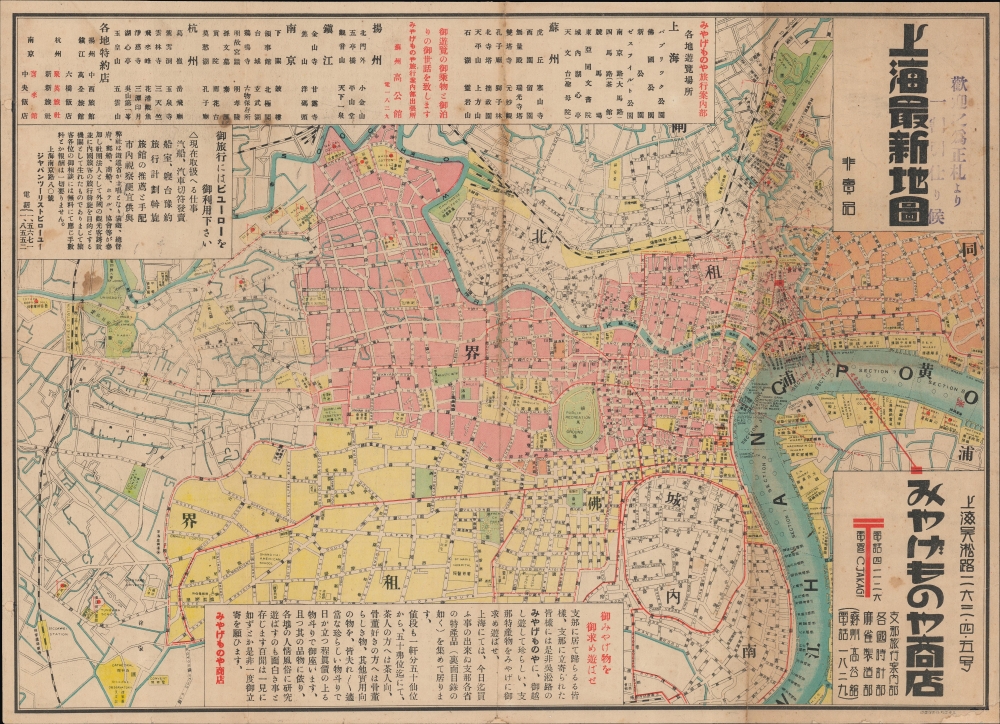
This is an attractive c. 1940 map of Shanghai issued by the Japanese-run Shanghai 'Souvenir Shop'. The map is based on an earlier map by Fusazō Sugie, but incorporates information and advertisements for Japanese travelers.
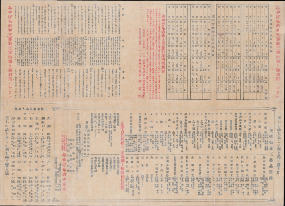
Extensive advertising, transport schedules, and notes on tourist sites in Shanghai, Suzhou, Yangzhou, Zhenjiang, Nanjing, and Hangzhou, are included. The verso features further details on visiting surrounding cities and attractions throughout Jiangnan, including bus schedules, comments on local handicrafts, and hotels.
In the early 20th century, Japanese migrants emerged as an increasingly prominent segment among the foreign residents of Shanghai. They tended to settle in Hongkou, on the north side of the Suzhou Creek in the International Settlement, as seen here. The growing Japanese presence created tensions with the established Anglo-American elite, who hesitated to allow Japanese representatives on the city's governing bodies, including the Shanghai Municipal Council and Chamber of Commerce. At the same time, Japan's rising militarism and territorial encroachments against China, and a resulting surge in Chinese nationalism, caused friction between Shanghai's Japanese and Chinese communities. Particularly after the Battle for Shanghai in 1937, the Japanese population boomed, bringing in more working-class migrants. This period marked the high point of Japanese influence in Shanghai, with tens of thousands of Japanese nationals residing in the city and their businesses, military, and culture exerting an ever greater influence. For four years, the foreign concessions sat as a 'solitary island' surrounded by Japanese-occupied territory. When Japan attacked Pearl Harbor in December 1941, the foreign concessions of Shanghai were occupied, and the city fell under Japanese military administration.
A Closer Look
Coverage embraces the central districts of Shanghai, including the Shanghai International Settlement, the French Concession, and adjoining Chinese-administered quarters. Outside of the predominantly Japanese Hongkou (center towards top-right, near the 租 character in 同租界), where the 'Souvenir Shop' was located, Japanese businesses, schools, and other institutions are marked by flags. The map is in both Chinese and English, as in Fusazō's original, with streets, schools, businesses, and other institutions labeled. Streetcar lines are traced in red, while interurban railways appear as black dashed lines.Extensive advertising, transport schedules, and notes on tourist sites in Shanghai, Suzhou, Yangzhou, Zhenjiang, Nanjing, and Hangzhou, are included. The verso features further details on visiting surrounding cities and attractions throughout Jiangnan, including bus schedules, comments on local handicrafts, and hotels.
Shanghai in the Treaty Port Era
Although it was already a sizable port in 1842, Shanghai expanded at a tremendous pace when it was designated a treaty port after the First Opium War (1839 - 1842). British and French traders were leased land along the waterfront (Bund). Due to the extraterritoriality clauses of the Treaty of Nanjing and subsequent 'unequal treaties,' these lands became exempt from Chinese jurisdiction. In 1862, the French split with the Americans and British, creating a distinct French Concession, leading the 'Anglos' to form the International Settlement. As a strategically located entrepôt near the mouth of the Yangtze River, Shanghai became the gateway to the entire Yangtze Delta. The light administration of the foreign concessions led to the city's reputation for economic dynamism, multiculturalism, partying, crime, drugs, prostitution, and urban poverty.In the early 20th century, Japanese migrants emerged as an increasingly prominent segment among the foreign residents of Shanghai. They tended to settle in Hongkou, on the north side of the Suzhou Creek in the International Settlement, as seen here. The growing Japanese presence created tensions with the established Anglo-American elite, who hesitated to allow Japanese representatives on the city's governing bodies, including the Shanghai Municipal Council and Chamber of Commerce. At the same time, Japan's rising militarism and territorial encroachments against China, and a resulting surge in Chinese nationalism, caused friction between Shanghai's Japanese and Chinese communities. Particularly after the Battle for Shanghai in 1937, the Japanese population boomed, bringing in more working-class migrants. This period marked the high point of Japanese influence in Shanghai, with tens of thousands of Japanese nationals residing in the city and their businesses, military, and culture exerting an ever greater influence. For four years, the foreign concessions sat as a 'solitary island' surrounded by Japanese-occupied territory. When Japan attacked Pearl Harbor in December 1941, the foreign concessions of Shanghai were occupied, and the city fell under Japanese military administration.
Publication History and Census
This map was issued by 'Souvenir Shop' (みやげものや商店), which appears to be the name of the business rather than a descriptor. The shop's telegram code (電略) is 'C. Takagi,' likely the proprietor, though no further information is known. The map is marked 'not for sale' (非賣品) and was likely given out at the shop; a stamp next to the title suggests customers could use it like a coupon and receive a discount. The map is derived from Fusazō Sugie's similarly-titled map of Shanghai (上海新地圖, previously sold by us), itself printed in multiple editions between 1926 and the mid-1930s. The only known institutional holding is with the Mirai-on (Nagasaki Prefecture and Omura City Library). The Toyo Bunko Museum (東洋文庫) may also hold an example as part of their modern China collection (近代中国研究委員会収集), but the information provided in the catalog listing is insufficient to say with certainty.Cartographer
Fusazō Sugie (杉江房造; fl. c. 1910 – 1950) was a Japanese bookseller, printer, and active in Shanghai during the final years of the Qing. Fusazō was the owner of the Nihon-do Japanese Bookstore (日本堂書店) in Shanghai, located at 155 Hong-Kou-Wen Street and 237 Woosung Road. He issued numerous guidebooks, souvenir photo books, and maps associated with Shanghai and Nanjing, many of which were bilingual and marketed to American and European tourists and servicemen. His bilingual New Map of Shanghai, published in various states and editions from 1931 well into the 1940s, is his most notable cartographic work. More by this mapmaker...
Condition
Very good. Laid down on archival tissue. Advertisements and travel schedules on verso. Some wear and soiling along original fold lines. Slight loss repair on margins.
References
Mirai-on (Nagasaki Prefecture and Omura City Library) Call No. (請求記号) 17/3001/167. Toyo Bunko Modern China Research Committee Collection (東洋文庫 近代中国研究委員会収集) Call No. 3263.