This item has been sold, but you can get on the Waitlist to be notified if another example becomes available, or purchase a digital scan.
1927 Y. Utne Wall Map of Shangahi Harbor, China
ShanghaiHarbour-utne-1927$9,000.00

Title
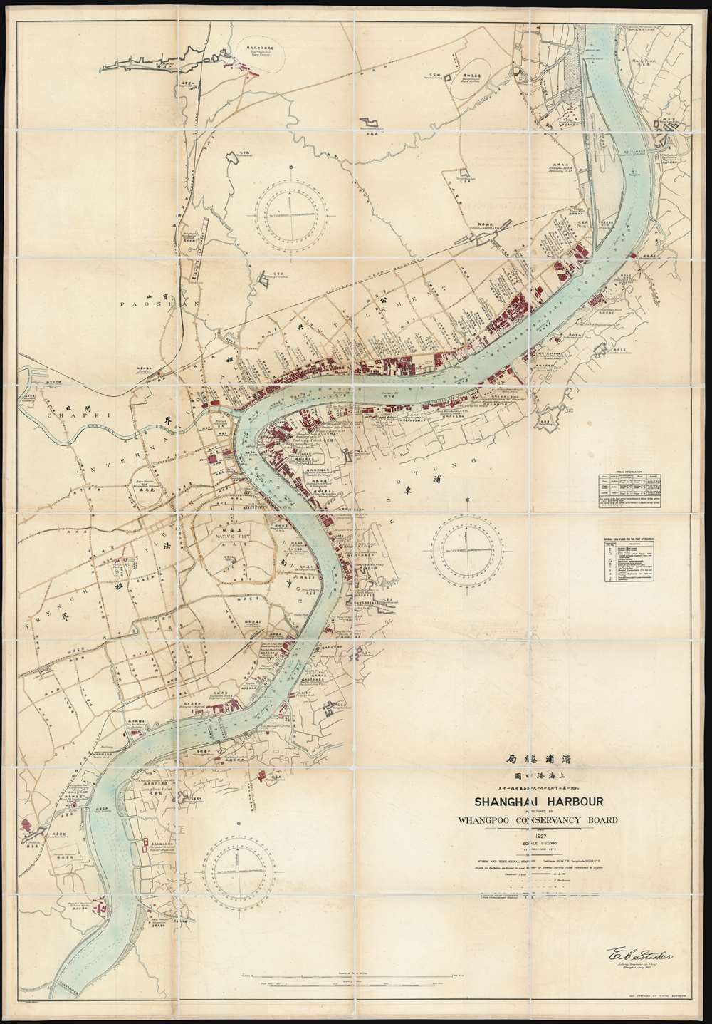
Shanghai Harbour Published by the Whangpoo Conservancy Board.
1927 (dated) 62.5 x 43.5 in (158.75 x 110.49 cm) 1 : 12000
1927 (dated) 62.5 x 43.5 in (158.75 x 110.49 cm) 1 : 12000
Description
A massive and previously unknown 1927 separate issue dissected wall map of Shanghai, China published by E. C. Stacker and Y. Utne for the Whangpoo Conservancy Board. Centered on the Shanghai Bund, the map details development along the Huangpu River (黄浦江, Whangpoo) from, roughly, the modern district of East Gate (小东门), south to Longhuacun (龙华村). While the focus is on riverside development, wherein individual buildings, docks, diplomatic offices, public utilities, parks, and business are noted; major inland roads are also identified in both English and Chinese.
The Whangpoo Conservancy Board
The Whangpoo Conservancy Board can trace its origins to the Boxer Rebellion of 1899 -1901. After the rebellion was suppressed, the Treaty Powers gained additional concessions and freedoms in China, among them the right to dredge the Huangpu RIver, turning Shanghai into a major deep water port. The organization was formally founded by the 1901 Boxer Protocol. Although initially foreign controlled, from about 1905, Chinese officials took over the WCB, establishing an executive board consisting of the Kiangsu Commissioner for Foreign Affairs, the Shanghai Commissioner of Customs, and the Shanghai Harbor Master; as well as a six-member consolatory board of Treaty Power representatives. Funded by harbor taxes, the task of the WCB was to oversee improvement on the Huangpu River around Shanghai. They managed lights, dredging operations, piers, jetties, and more. The WCB could also exercise eminent domain seizures of any riverside lands outside of the foreign settlements as deemed necessary for improvements. Operations were suspended during the Japanese invasion of 1936, but resumed around 1940.Shanghai 1910 - 1932
The 1910s-20s were a golden age for Shanghai. While China was ruled by Chiang Kai-shek, Shanghai was dominated by several consolidated foreign trade Concessions. Under the strict administrative control of the Concessions, the city became a cosmopolitan haven in the midst of political unrest and a center for global trade and finance. The Concessions occupied what is today central Shanghai's most desirable land, hugging the Huangpu River and Wusong River (Suzhou Creek). These extraterritorial European, Japanese, and American enclaves had elegant housing, fine roads, streetcars, elegant shops, clubs, and more. It was a place of excess, art, and extravagance, where fortunes could be made by the enterprising - and lost by the foolish. Moreover, lacking the moral constrains that limited social life in Europe and America, Shanghai became nexus for the opium trade, sexual excess, gambling, and other vices. This ephemeral world come crashing down on January 28, 1932, when the Shanghai Incident or January 28 Incident pitted the Republic of China against the Empire of Japan. Responding to Chinese student protests against the Japanese occupation of Manchuria, the Japanese Navy bombarded Shanghai. Chiang Kai-shek sent the Chinese army in to defend the Shanghai students, threatening to escalate the conflict. The League of Nations, fearing all-out war, united to demand a ceasefire, which was signed. Nonetheless, most consider The January 28 incident to be the opening salvo of the Second Sino-Japanese War (1938 - 1945) which ultimately merged into World War II.Publication History and Census
This map was published by the Whangpoo Conservancy Board under the direction of E. C. Stacker. The map was laid out by Y. Utne. We have been able to isolate no other surviving examples.CartographerS
Y. Utne (fl. c. 1909 - 1936) was a surveyor active in Shanghai prior to World War II. Utne surveyed for the Whangpoo Conservancy Board from at least 1909, when he is listed as an 'Assistant Surveyor,' to the date of his last known work, 1934. He surveyed several detailed maps of the Huangpu River in the vicinity of Shanghai. Utne returned to England with the Japanese invasion of Shanghai in 1936, where he is listed on the Empress of Asia passenger manifest as the 'Chief Surveyor' of the WCB. More by this mapmaker...
E. C. Stacker (fl. c. 1922 - 1927) was an American engineer active in Shanghai prior to World War II. Stacker worked as 'Acting Engineer in Chief' of the Whangpoo Conservancy Board from at least 1922 to 1927. He was also elected president of the Shanghai American Club in that year. Learn More...
Condition
Very good. Even overall toning. Fresh linen backing. Custom slipcase.