1917 Jin Feng She 'Nem' or 'New' Map of Shanghai, China
ShanghaiNemMap-jinfengshe-1917$1,400.00


Title
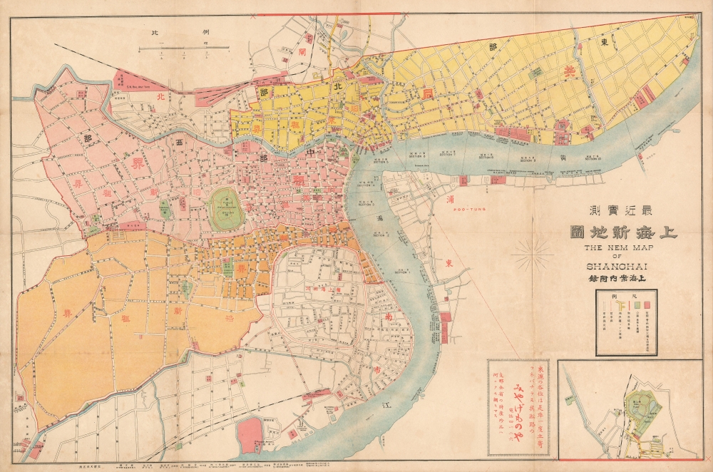
The Nem Map of Shanghai. / 'Recently Measured New Map of Shanghai.' / 最近实测上海新地图
1917 (dated) 20 x 30.25 in (50.8 x 76.835 cm) 1 : 15840
1917 (dated) 20 x 30.25 in (50.8 x 76.835 cm) 1 : 15840
Description
This is the 1917 bilingual 'Nem' map of Shanghai, China by Jin Feng She (金鳳社) / Chojiro Shimazu (島津長治郎). The map captures Shanghai's pre-WWII golden age, when it was a cosmopolitan center of international commerce, and a hotbed of wild excess.
A Closer Look
'Nem' is a typo, with the Japanese publisher erroneously inverting the 'W' in 'New'. Centered on the Bund, the primary riverfront business district, the map covers the International Settlement, British Concession (pink), and French Concession (orange) - which, three years earlier in 1914, was radically expanded (light orange area). There is an advertisement, to the left of the inset, for 'みやげもの相连' a Japanese specialty and souvenir store on Wusong Road.Lu Xun Park
This map is unique for its inset in the lower right, actually an extension that can be cut out and pasted to the top of the map, a cleaver and flexible way to deal with irregular urban forms, intended to incorporate the expansion of Lu Xun Park ('New Park'). Also known as Hongkou (Hongkew) Park, this park was proposed in 1896 as a shooting range for the multinational Shanghai Volunteer Corps. In 1917, the small park underwent several major expansions, incorporating a golf course, tennis courts, a swimming pool, and a bowling green. There can be little doubt that general interest in these developments inspired the cartographer to add it to this map. The park subsequently hosted the 1921 Far Eastern Championship Games.Shanghai 1910 - 1932
The 1910s-20s were a golden age for Shanghai. While Chiang Kai-shek ruled China, Shanghai was dominated by several consolidated extraterritorial Concessions. Under the strict administrative control of the Concessions, the city became a cosmopolitan haven amid political unrest and a center for global trade. The Concessions occupied central Shanghai, hugging the Huangpu River and Wusong River (Suzhou Creek). These extraterritorial European, Japanese, and American enclaves had grandiose housing, fine roads, streetcars, elegant shops, clubs, and more. It was a place of excess, art, and extravagance, where fortunes could be made by the enterprising - and lost by the foolish. Moreover, lacking the moral constraints that limited social life in Europe and America, Shanghai became a nexus for the opium trade, sexual excess, gambling, and other vices. This ephemeral world came crashing down on January 28, 1932, when the Shanghai Incident pitted the Republic of China against the Empire of Japan. Responding to Chinese student protests against the Japanese occupation of Manchuria, the Japanese Navy bombarded Shanghai. Chiang Kai-shek sent the Chinese army in to defend the Shanghai students, threatening to escalate the conflict. The League of Nations, fearing all-out war, united to demand a ceasefire, which was signed. Nonetheless, most consider The Shanghai Incident, or as it is also known, the January 28 Incident, to be the opening salvo of the Second Sino-Japanese War (1938 - 1945) which ultimately merged into World War II (1939 - 1945).Shanghai International Settlement
The Shanghai International Settlement was created in 1863 when the British and American Shanghai enclaves merged. These concessions were granted to England and the United States as part of the Unequal Treaties that followed the Opium Wars. From 1854, the settlements were governed by the Shanghai Municipal Council, a British-dominated board of government officials and powerful merchants. The board issued restrictions limiting Chinese habitation on International Settlement territory and oversaw the construction of public services, including trams, a sewage system, highways, and port buildings. The International Settlement expanded several times in the late 19th and early 20th century. It became an enclave of peace and prosperity when the Japanese invaded Shanghai in 1937, but this abruptly came to an end with the Japanese bombing of Pearl Harbor and 1941 invasion of the International Settlement. After the war, the International Settlement lands were returned to Chinese sovereignty.Shanghai French Concession - 上海法租界
On April 6, 1849, Lin Kouei (麟桂), the Chinese governor of Shanghai, granted French Consul Charles de Montigny (1805 - 1868) a proclamation ceding extraterritoriality to France in order to establish a trading colony. The Concession initially occupied a narrow collar of 66 hectares around the northern end of the Chinese City, south of the British settlement. It was subsequently expanded several times. A further small strip of riverside land to the east of the Chinese City was added in 1861, to allow for the Quai de France, docks servicing shipping between China and France. Between 1899 and 1900, the French Concession further expanded, nearly doubling in size with new territory west of the original grant. It expanded again in 1914, reaching as far west as modern-day Huashan Lu (Avneue Haig) - as mapped here just 3 years after the expansion. By the 1920s, the western part of the French Concession became the most desirable residential area of Shanghai, popular both with foreign nationals and wealthy Chinese. The concession was mistakenly bombed during the chaotic 1937 Battle of Shanghai, fought between the National Revolutionary Army (NRA) of the Republic of China (ROC) and the Imperial Japanese Army (IJA). In 1943, the French Concession was handed over to the Japanese puppet Wang Jingwei Regime by Vichy France. The turnover was officially ratified after the war by the Sino-French Accord of February 1946, signed by the French Ambassador and Chiang Kai-shek. Today, the French Concession, with its tree-lined boulevards and French colonial architecture, remains Shanghai's most desirable neighborhood.Publication History and Census
This map was printed on printed on March 16, Taisho 6, 1917, and released four days later on March 20. It was issued by Chojiro Shimazu (島津長治郎) of the Jin Feng She (金鳳社) press. Examples are exceedingly scarce. We have identified no examples outside of China, but at least two examples in Chinese institutional collections. There also appear to be at least two editions, one with and one without the inset in the lower right. It is unclear which is earlier.Cartographer
Chojiro Shimazu (島津長治郎, fl. c. 1900 - 1927) was a Japanese publisher based in Shanghai, China. Chojiro arrived in China around 1900, establishing himself in the pharmaceutical business. He began publishing in 1912, founding Jin Feng She (金鳳社) press. Under his leadership, the press published several Japanese language guidebooks, maps, directories, and more. More by this mapmaker...
Condition
Very good. Minor wear along original fold lines.