This item has been sold, but you can get on the Waitlist to be notified if another example becomes available, or purchase a digital scan.
1927 Sugie Fusazo Map of Shanghai w/ Trams
ShanghaiTrams-fuzao-1927$175.00

Title
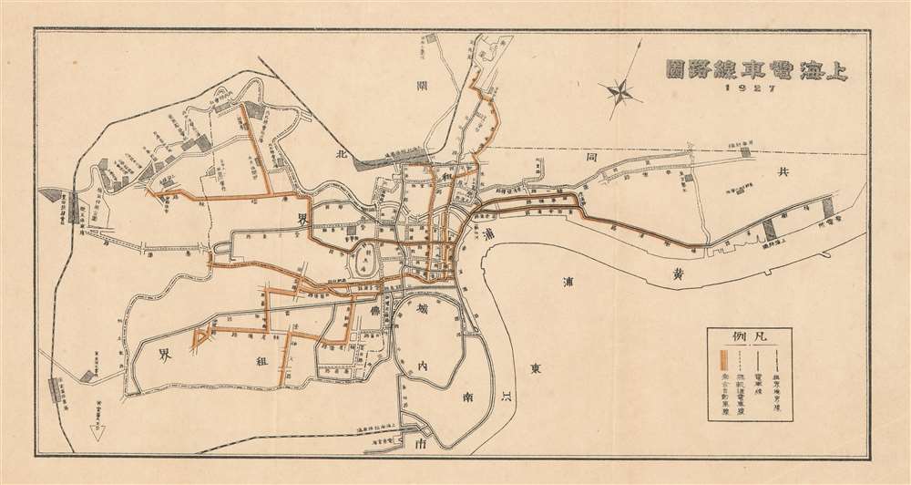
Shanghai Tram Line Map. / 上海電車線務圖
1927 (dated) 6 x 11.25 in (15.24 x 28.575 cm)
1927 (dated) 6 x 11.25 in (15.24 x 28.575 cm)
Description
An uncommon 1927 Sugie Fusazo map of Shanghai, China, illustrating transportation networks. The map focuses on Shanghai's developing electric tram line - which is here highlighted in yellow. Shanghai's tram network, one of the first in Asia, offered comprehensive public transport through the Foreign Concessions.
Trams of Shanghai
Trams in Shanghai began operating in 1908 using a steel wheeled electric system. Three tram companies expanded their routes step by step, and collectively reached their maximum extent in 1925 with 328 tramcars and 14 routes. The British system was the largest with seven routes and 216 trams; the French system, had three routes and 60 trams; the Chinese system and operated 52 trams on four routes totaling 23.5 km in length.Shanghai 1910 - 1932
The 1910s-20s were a golden age for Shanghai, at least in the Concessions. While China was ruled by Chiang Kai-shek, Shanghai was dominated by several consolidated foreign trade Concessions. Under the strict administrative control of the Concessions, the city became a cosmopolitan haven in the midst of political unrest and a center for global trade and finance. The Concessions occupied what is today central Shanghai's most desirable land, hugging the Huangpu River and Wusong River (Suzhou Creek). These extraterritorial European, Japanese, and American enclaves had modern housing, fine roads, streetcars, elegant shops, clubs, and more. It was a place of excess, art, and extravagance, where fortunes could be made by the enterprising - and lost by the foolish. Moreover, lacking the moral constrains that limited social life in Europe and America, Shanghai became nexus for the opium trade, sexual excess, gambling, and other vices. This ephemeral world come crashing down on January 28, 1932, when the 'Shanghai Incident' or 'January 28 Incident' pitted the Republic of China against the Empire of Japan. Responding to Chinese student protests against the Japanese occupation of Manchuria, the Japanese Navy bombarded Shanghai. Chiang Kai-shek sent the Chinese army in to defend the Shanghai students, threatening to escalate the conflict. The League of Nations, fearing all-out war, united to demand a ceasefire, which was signed. Nonetheless, most consider The January 28 incident to be the opening salvo of the Second Sino-Japanese War (1938 - 1945) which ultimately merged into World War II.Publication History and Census
This small map was published by Sugie Fusazo in 1927, as dated. Uncommon on the market and not in Virtual Shanghai.Cartographer
Fusazō Sugie (杉江房造; fl. c. 1910 – 1950) was a Japanese bookseller, printer, and active in Shanghai during the final years of the Qing. Fusazō was the owner of the Nihon-do Japanese Bookstore (日本堂書店) in Shanghai, located at 155 Hong-Kou-Wen Street and 237 Woosung Road. He issued numerous guidebooks, souvenir photo books, and maps associated with Shanghai and Nanjing, many of which were bilingual and marketed to American and European tourists and servicemen. His bilingual New Map of Shanghai, published in various states and editions from 1931 well into the 1940s, is his most notable cartographic work. More by this mapmaker...
Condition
Very good. Minor toning.