1973 Weekend Outdoor Fishing and Recreation Map of Shasta Lake, California
ShastaLake-weekendoutdoor-1973$200.00

Title
Shasta Lake.
1973 (undated) 21.75 x 28.75 in (55.245 x 73.025 cm) 1 : 45000
1973 (undated) 21.75 x 28.75 in (55.245 x 73.025 cm) 1 : 45000
Description
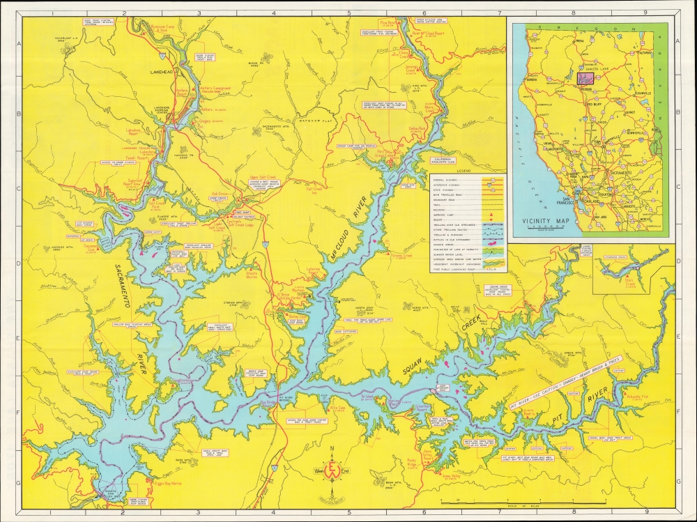
A brilliantly-colored c. 1973 Weekend Outdoor Production map of Lake Shasta, northern California, highlighting fishing and recreation.
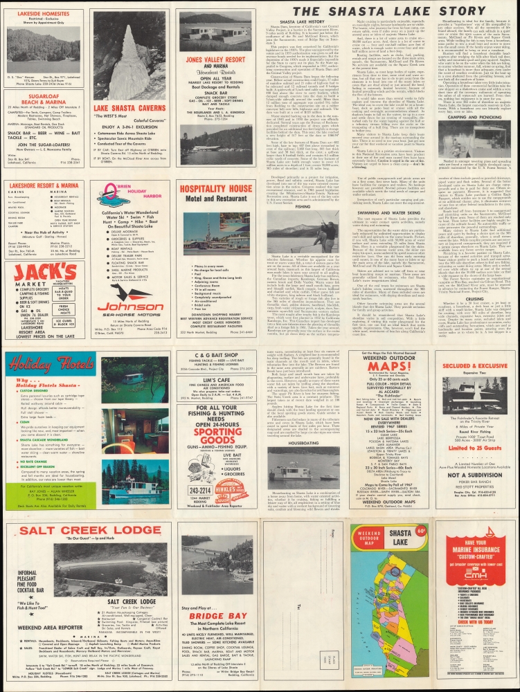
The verso includes advertisements for businesses of interest to tourists, such as accommodations (including 'flotel' houseboats), restaurants, bait and tackle shops, and more. A text section at top-right discusses the history of the dam and reservoir and the opportunities for outdoor recreation there. The folding map is formatted as a mailer, so the address line appears on the outside when folded.
A Closer Look
Situated at the confluence of the Sacramento, McCloud, and Pit Rivers and several tributaries, Lake Shasta is a reservoir formed by a massive dam built in the 1930s and early 1940s (discussed below). Aside from the main rivers forming the reservoir, mountains (with elevations noted), creeks, and other natural features are indicated, Campgrounds, resorts, trailer parks, marinas, highways (Interstate-5), and other roads, rail lines, hiking trails, and sites relevant for visitors are also identified. Notes relating to fishing appear throughout, including good locations and methods for catching fish, as well as the prominent species. A legend appears at right, along with a small inset of the area around Stein Creek, southeast of the area seen here, and a larger inset of northern California, displaying highways and interstates.The verso includes advertisements for businesses of interest to tourists, such as accommodations (including 'flotel' houseboats), restaurants, bait and tackle shops, and more. A text section at top-right discusses the history of the dam and reservoir and the opportunities for outdoor recreation there. The folding map is formatted as a mailer, so the address line appears on the outside when folded.
The Shasta River and California's Water Crisis
Through both natural and manmade means, including the Shasta Dam (completed 1945) and the resulting Shasta Lake, runoff from Mt. Shasta and other nearby mountains provides much of the freshwater for areas to the south, especially the Central Valley, an agricultural powerhouse. The dam, one of the largest in the world, was an engineering marvel and, when completed in 1945, was hailed as the crowning achievement of the federal government's Central Valley Project. As California's sources of freshwater have been imperiled in recent years by droughts and rising temperatures, proposals have been made to raise the dam to allow for greater storage of the abundant waters running off the mountains along the California-Oregon border. Environmental groups and the indigenous Wintun people, whose lands were almost entirely flooded by the original dam project, have opposed these efforts.Publication History and Census
This map was prepared and published by Weekend Outdoor Productions around 1973. A smaller, alternative printing, paradoxically marked as a 'deluxe edition,' is cataloged among the holdings of the University of California Davis and the Library of Congress in the OCLC, while the present printing appears unrecorded.Cartographer
Weekend Outdoor Productions (c. 1955 - 1975) was an Oakland, California-based publisher of maps, mostly dealing with attractions in northern California, with a smaller number of maps focusing on southern California attractions and Hawaii. Most of their maps provided information on fishing, hunting, and other outdoor activities. More by this mapmaker...
Condition
Very good. Light wear along original folds. Text on verso.
References
OCLC 5485597 (different edition).