This item has been sold, but you can get on the Waitlist to be notified if another example becomes available, or purchase a digital scan.
1861 Japanese Sato Seiyo Map of the World on Mercator Projection
ShinkanYochiZenzu-satomasayasu-1861$1,625.00


Title
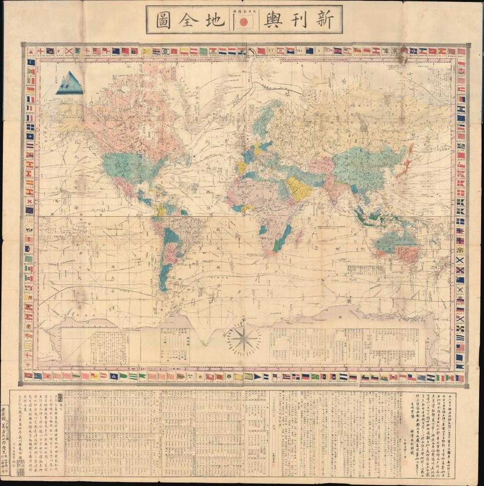
新刊舆地全圖 / Shinkan Yochi Zenzu. / Latest Map of the World.
1861 (dated) 54 x 54 in (137.16 x 137.16 cm) 1 : 34200000
1861 (dated) 54 x 54 in (137.16 x 137.16 cm) 1 : 34200000
Description
An impressive 1861 (Bunkyū 1) Japanese map of the world on a Mercator projection by Satō Masayasu, a translator and expert on Dutch learning in the late Tokugawa Period (1600 - 1868). It reflects the tentative but increased circulation of foreign geographical knowledge in the 1860s, as the Tokugawa scrambled to modernize and secure their tenuous rule over Japan.
Tables within the border of the map discuss the Earth's area, population, fauna, and usable land. Text and further tables at bottom explain the map's formulation, being based on an earlier Dutch map (discussed below), information on the world's major mountain ranges and river systems (the relative heights of mountains also being illustrated within the map's border at top-left), and tables of distances from major points throughout the globe from London and New York. This work was revolutionary in Japan, where it was among the first to be issued on a Mercator projection, thus ushering in a new global perspective in Japanese cartography.
Nevertheless, some Japanese intellectuals, particularly of the 'Dutch Learning' (Rangaku) School, were aware of developments in Europe and the Tokugawa became quietly but increasingly concerned about foreign threats, moving to exert greater control over the northern region known as Ezo (蝦夷), including Hokkaido, in the early 19th century. News of China's defeat in the First Opium War (1839 - 1842), was also a deeply ominous sign.
Perry's timing was impeccable, as the leadership of the Tokugawa was in disarray when he reached Japan, with the aging Tokugawa Ieyoshi dying soon after the Americans' arrival, succeeded by his sickly son Tokugawa Iesada, in effect leaving a regency of Abe Masahiro and other top-level advisors. Abe felt that it was impossible for Japan to resist the American demands by military force and, by the time Perry returned in 1854, decided to accept virtually all the demands in Fillmore's letter. Other European powers soon piled in, demanding similar concessions from the Tokugawa. However, the details of Japan's opening took time to hammer out and the country's first treaty ports, including Yokohama, only opened at the end of the 1850s.
The sudden opening of Japan to foreign trade and influence coincided with long-building issues in the Tokugawa system and set off a complete social and economic crisis. Samurai and daimyo in southern Japan, who had been the enemies of the Tokugawa over two centuries before and never been happy with their rule, sensed an opportunity. Rebellions were launched to 'restore' the emperor in Kyoto, for centuries a symbolic figure only, to a central political role, topple the Tokugawa, and expel the foreigners. By 1868, the rebels had succeeded in the first two goals, but recognizing the gap between Japan and the West embraced rather than banished foreign influence, leading Japan down a path of rapid modernization.
Satō's map was published concurrently with Takeda Kango's map of the world, helping to introduce recent European world maps to Japan (both maps use a Mercator Projection and include extensive information on navigation and recent voyages of discovery). It also was the basis for Miyazaki Ryūjō's (宮崎柳条) 1875 untitled map of the world, which was updated with information for Hermann Berghaus' world map (both previously sold by us).
A Closer Look
This is an enormous and graphically extraordinary map covering the entire world on Mercator's projection and surrounded by 159 flags of various foreign nations. Japan's flag is given the prime spot in the title at top, while Dutch (at top-center along the border) and Chinese / Qing (bottom-center of border) flags are also given prominence. Countries are color-shaded for easy distinction. The routes of famous explorers, major shipping routes (especially those between Europe, India, Indonesia, and Australia), multiple compass roses, extensive information on latitude and longitude, and many other pieces of information are noted throughout.Tables within the border of the map discuss the Earth's area, population, fauna, and usable land. Text and further tables at bottom explain the map's formulation, being based on an earlier Dutch map (discussed below), information on the world's major mountain ranges and river systems (the relative heights of mountains also being illustrated within the map's border at top-left), and tables of distances from major points throughout the globe from London and New York. This work was revolutionary in Japan, where it was among the first to be issued on a Mercator projection, thus ushering in a new global perspective in Japanese cartography.
Cartographic Source
Satō's text at bottom claims that this map follows the 1857 Wereldkaart, naar en met de lasste ontdekkings-reizen of C. F. Stemler, though only later editions of Stemler map appear to have survived to the present. These later editions are much smaller than the present map and may have appeared in Stemler's Atlas der Wereld, suggesting that Satō greatly increased the map's size and added information from elsewhere, providing a concise but comprehensive overview of global geography. Stemler's map was possibly introduced to Japan by Dutch arms dealers in Yokohama, Edward and Henry Schnell. In any event, as an expert of 'Dutch learning' trained in both translation and surveying (see biography below), Satō was the ideal person to translate Stemler's map for a Japanese audience.The End of Japanese Isolation
This map was published less than a decade after American 'black ships' led by Commodore Mathew Perry arrived in Tokyo Bay. Perry had a commission from American President Millard Fillmore (1800 - 1874) to force the opening of Tokugawa Japan's seaports to American trade and diplomacy. For the previous 214 years, Japan operated under Sakoku (鎖国, 'Locked-Country') policies, where limited foreign trade and interaction was allowed with the Dutch and Chinese at Nagasaki and through other tightly constrained channels, but otherwise was strictly limited to prevent potentially troublesome foreign ideas like Christianity from undermining Tokugawa rule.Nevertheless, some Japanese intellectuals, particularly of the 'Dutch Learning' (Rangaku) School, were aware of developments in Europe and the Tokugawa became quietly but increasingly concerned about foreign threats, moving to exert greater control over the northern region known as Ezo (蝦夷), including Hokkaido, in the early 19th century. News of China's defeat in the First Opium War (1839 - 1842), was also a deeply ominous sign.
Perry's timing was impeccable, as the leadership of the Tokugawa was in disarray when he reached Japan, with the aging Tokugawa Ieyoshi dying soon after the Americans' arrival, succeeded by his sickly son Tokugawa Iesada, in effect leaving a regency of Abe Masahiro and other top-level advisors. Abe felt that it was impossible for Japan to resist the American demands by military force and, by the time Perry returned in 1854, decided to accept virtually all the demands in Fillmore's letter. Other European powers soon piled in, demanding similar concessions from the Tokugawa. However, the details of Japan's opening took time to hammer out and the country's first treaty ports, including Yokohama, only opened at the end of the 1850s.
The sudden opening of Japan to foreign trade and influence coincided with long-building issues in the Tokugawa system and set off a complete social and economic crisis. Samurai and daimyo in southern Japan, who had been the enemies of the Tokugawa over two centuries before and never been happy with their rule, sensed an opportunity. Rebellions were launched to 'restore' the emperor in Kyoto, for centuries a symbolic figure only, to a central political role, topple the Tokugawa, and expel the foreigners. By 1868, the rebels had succeeded in the first two goals, but recognizing the gap between Japan and the West embraced rather than banished foreign influence, leading Japan down a path of rapid modernization.
Publication History and Census
This map was edited, overseen, and translated and elaborated from the original Dutch by Satō Masayasu (佐藤政養). It was engraved by Takeguchi Takisaburō (竹口瀧三郎) and Uemura Fukusaburō (上村福三郎), and published by Yorozuya Heishiro (萬屋兵四郎) in Edo (whose print shop was titled 老皀館). The map is held by the University of California Berkeley, Yale University, the Bibliothèque nationale de France, the University of South Wales, and several institutions in Japan (the National Diet Library, the National Archives of Japan, Kobe University, the National Institute of Japanese Literature, the Tokyo Metropolitan Museum, and the Sapporo Municipal Central Library). The University of California Berkeley, the University of British Columbia, the National Diet Library, and the National Institute of Japanese Literature date their examples to 1862. This is mostly likely because Satō's preface is dated to the 11th month of Bunkyū 1, and the 12th month of Bunkyū 1 corresponded to January 1862, meaning the map was likely not distributed until 1862. However, some catalog listings include a slightly different title (官許新刊輿地全圖) and list of Sato's collaborators, suggesting a second printing in 1862.Satō's map was published concurrently with Takeda Kango's map of the world, helping to introduce recent European world maps to Japan (both maps use a Mercator Projection and include extensive information on navigation and recent voyages of discovery). It also was the basis for Miyazaki Ryūjō's (宮崎柳条) 1875 untitled map of the world, which was updated with information for Hermann Berghaus' world map (both previously sold by us).
Cartographer
Satō Masayasu (佐藤政養; 1821 - 1877), also sometimes read as Satō Seiyō, was a Rangaku (Dutch learning) scholar and expert on foreign technology in the late Tokugawa era (Bakumatsu). Born in Akumi, Yamaguchi Prefecture, he moved to Edo in 1853 to study a range of subjects, including Chinese classics, gunnery, and sculpture. In 1855, Satō began studies at the newly-established Nagasaki Naval Training Center (長崎海軍伝習所), an attempt by the Tokugawa government to build modern warships, where he also learned surveying. Soon afterwards, he was tasked with learning Dutch and translating foreign texts into Japanese for the Gunkan Training School (軍艦操練所), a training center for naval officers. In 1864, he was placed in charge of the Kobe Naval Training Center (神戸海軍操練所). After the Meiji Restoration, Satō joined the new government's nascent bureaucracy and was deeply involved with planning Japan's first railway line, between Yokohama and Tokyo. More by this mapmaker...
Condition
Very good. Minor traditional repairs along some folds. Else clean.
References
Yamashita, Kazumasa (traslated by De Wolf, Charles) Japanese Maps of the Edo Period, page 39. OCLC 222503925, 21834816, 1284872052. University of British Columbia Library, G3200.1862 T2 (1862 edition). Rumsey A12 (1862 edition).