This item has been sold, but you can get on the Waitlist to be notified if another example becomes available, or purchase a digital scan.
1710 Ottens Map of Southeast Asia: Singapore, Thailand (Siam), Malaysia, Sumatra, Borneo
Siam-ottens-1710$1,500.00

Title
Le Royaume de Siam avec Les Royaumes Qui Luy sont Tributaries & c. / La Royaume de Siam avec les royaumes qui luy sont Tributaires, et les Isles de Sumatra, Andemaon, etc. Et les Isles Voisine Aven les Observations des Six Peres Jesuites Envojez par le Roy en Qualite de Ses Mathe : maticiens dans les Indes, et a laChine ou est aussi Tracee. La Route Qu'ils ont teniie par le Destroit de la Sonde Jusqu a Siam.
c. 1710 (undated) 33 x 22 in (83.82 x 55.88 cm)
c. 1710 (undated) 33 x 22 in (83.82 x 55.88 cm)
Description
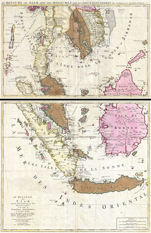
A fine example of Joachim Ottens' magnificent two part c. 1710 map of the Kingdom of Siam and its tributaries. Covers much of Southeast Asia and the East Indies including modern day Thailand, southern Vietnam, Cambodia, Malaysia, Singapore, Borneo, Sumatra and Java. This remarkable map was one of the largest and most detailed maps of this region to appear in the early 18th century. It was drawn by Joachim Ottens shortly before his death and was published by his sons and later republished as a single sheet map by Covens and Mortier.
The upper map focuses on the territories currently occupied by modern day Thailand, Cambodia, Vietnam, northern Borneo, and northern Malaysia. Offers wonderful detail the Andaman Islands, the Gulf of Thailand (Golfe de Siam) and coastal Vietnam. Also has good detail along the navigable inland river systems, particularly the Mekong and the Chao Phraya. In the Kingdom of Siam, this map shows the fortress of Bangkok, the ancient Siamese capital of Ayutthaya, royal palace, and the Dutch trading colony. In Cambodia, it details the village of Ponompingn (Phnom Penh), Lewek on Camboia, and the Dutch trading mission. In the seas this map offers numerous depth soundings and shows the trade routes between Batavia (Jakarta, Java) and Siam (Thailand). Also details the shoals and reefs off the coast of modern day Vietnam. Mountain regions are shown pictorially. Title in French across the top of the map, outside the neatline.
The bottom map details the southern parts of the Malay Peninsula, Sumatra, Borneo and Java focusing on the Straits of Singapore (Cingapura). Does not specifically name the Island of Singapore, but does show the island that would fatefully be settled in 1819 by Sir Thomas Stamford Raffles. Offers superb detail along the coasts naming numerous forts, trade missions, settlements and islands. Shows the trade routes between Siam and Batavia and illustrates some of the hazards of the Straits of Cingapura (Singapore). Offers numerous depth soundings along the western coast of Borneo, the northern coast of Java, and western Sumatra. Mountain regions are shown pictorially. Title in French occupies the lower left quadrant.
Cartographer
Ottens (fl. c. 1680 - 1785) was a prominent Amsterdam map publishing family active for nearly 100 years. Joachim Ottens (1663 - 1719) was born in Amsterdam to a family of seafarers and educated in Amsterdam's Evangelical Lutheran community. He likely learned copperplate engraving under Frederick de Wit (1629 - 1706), for whom he worked until about 1710. In 1710, he was admitted to the Sint-Lucasgilde (Guild of St. Luke) and, in 1711, Joachim founded his own firm. Although Joachim died only a few years later, in 1719, his widow continued the business, either publishing as either 'I. Ottens', 'Ottens', or 'In de Wereldcaert' [In the World Map]. In 1726, Joachim Otten's sons, Renier (1698 - 1750) and Joshua (1698 - 1750), established a partnership and generally published as 'R. and I. Ottens'. Although they ran separate shops, on Nieuwendijk and Kalverstraat, they worked jointly as a singular business until Renier's death in 1750, at which point Joshua assumed full control. After Joshua's death in 1765, his widow continued the firm with their son, Renier II, changing the imprint to 'Joshua and Reinier Ottens.' Joshua's widow, Johanna de Lindt, held an auction sale of their engraved plates in 1784. Ottens' work stands out in that all of their maps were separate issues, though often found compiled into special, made-to-order multi-volume composite Atlas factice works, such as the Atlas. Some examples of the Atlas include over 800 separately issued maps. Because they were not uniformly issued in standard atlases, Ottens maps are often of the utmost rarity and are notable for their exceptionally rich engraving. More by this mapmaker...
Source
This map set would have been compiled into one of the Ottens' made-to-order atlases such as the magnificient Atlas Major.
Condition
Very good condition. Light overall toning and very minor offsetting. Original centerfold. Original color. Platemark visible on both sheets. Wide margins. Blank on verso.
References
Koeman, C., Atlantes Neerlandici. Bibliography of Terrestrial, Maritime and Celestial Atlasesand Pilot Books, Published in the Netherlands up to 1880, (6 vols), Vol. II, C&M (80), p. 75. Parry, D., The Cartography of the East India Islands, Insulae Indiae Orientalis, p. 177. National Library of Australia, MAP RM 184.