This item has been sold, but you can get on the Waitlist to be notified if another example becomes available, or purchase a digital scan.
1870 Manuscript Master Plan of for Catholic Missions in Sichuan, China
SichuanMissions-missionsetrangeres-1870$2,500.00


Title
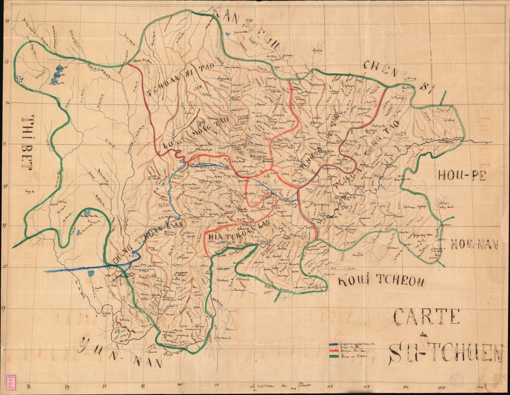
Carte du Su-Tchuen.
1870 (undated) 29.5 x 38 in (74.93 x 96.52 cm) 1 : 1368000
1870 (undated) 29.5 x 38 in (74.93 x 96.52 cm) 1 : 1368000
Description
An exceptional large-scale c. 1870 manuscript map of Sichuan Province, China, illustrating French Catholic missionary activity. This is likely the master map compiled and housed in the vicarial seat of Chongqing by which late 19th-century missionary work in Sichuan was organized. It is by far the most meticulous and detailed map of Sichuan to appear until the final years of the 19th-century.
The map is far more detailed than any known earlier map, Chinese or Western, with more accurate river courses, vastly more place names, and broader details - doubtless the product of first hand missionary accounts. It is, nonetheless, at least partially derived from the 1864 Chinese map Sichuan quan tu (四川全图), published in the Da Qing Yi Tong Yu Di Quan Tu (大清一统舆地全图 / [Complete map of the unified territory of the Qing]). From this map, certain stylistic conventions regarding the designation of Chinese cities are here inherited.
This map is likely the primary source for the three maps of the Sichuan missions compiled in Hong Kong in the 1880s by Adrien-Charles Launay (1852 - 1927), for this Histoire générale de la Société d. Missions-étrangéres, published in Paris in 1889. Although Launay's maps are more sophisticated, with additional detail, they feature much of the same conventions, nomenclature, and geographical content.
A Closer Look
The map covers all of Sichuan Province, at the time including Chongqing, and extends west as far as the Tibetan borders. It is divided into sections, likely representing Apostolic Vicarates, although the breakdown is unclear and seems to feature corrections. They roughly correspond to the three primary Sichuan missions as defined in 1889 by Adrien Launay: Mission du Su-tchuen Oriental (Tchoan Tong Tao), Mission du Su-tchuen Occidental (Tchoan Pe Tao, Long Mong Tao, and Tchoan Si Tao), and Mission du Su-tchuen Méridionale (Hia Tchoan Lan and parts of Chang Tchoan Lan). Unattributed lands to the west are unlabeled but likely refer to the Mission du Tibet. The map is coded with symbols to define the sizes of various cities and villages, as well as the Catholic missionary presence there,- Squares w/dots - Provincial Capitals. (Fou / Fu) (Examples: Chengdu, Chongqing)
- Diamonds - Prefecture-level cities (Tcheou / Ting) with resident missionaries.
- Circles with Dots - Sub-Prefecture level towns (Tcheou, Ting).
- Circles - Department level villages (Hien / Hsien).
- Triangles - District hamlets and/or possibly ancient sites.
- Crosses - Catholic Seminaries.
- ** Red highlighting indicates the presence of Catholic missionaries.
The map is far more detailed than any known earlier map, Chinese or Western, with more accurate river courses, vastly more place names, and broader details - doubtless the product of first hand missionary accounts. It is, nonetheless, at least partially derived from the 1864 Chinese map Sichuan quan tu (四川全图), published in the Da Qing Yi Tong Yu Di Quan Tu (大清一统舆地全图 / [Complete map of the unified territory of the Qing]). From this map, certain stylistic conventions regarding the designation of Chinese cities are here inherited.
This map is likely the primary source for the three maps of the Sichuan missions compiled in Hong Kong in the 1880s by Adrien-Charles Launay (1852 - 1927), for this Histoire générale de la Société d. Missions-étrangéres, published in Paris in 1889. Although Launay's maps are more sophisticated, with additional detail, they feature much of the same conventions, nomenclature, and geographical content.
The Sichuan Missions
Located in what was then the western frontier of the Chinese Empire, the Sichuan missions were particularly vulnerable to anti-Christian anti-foreign sentiment. Although the treaties demanded the protection and fair treatment of both missionaries and converts, in practice, local magistrates and other officials, dependent upon the existing Confucian-based power structure, resented missionary influence and exercised considerable latitude in treaty enforcement. As such, incidents against both Christians and Missionaries, including social and economic exclusion, and even massacres, occurred more commonly in Sichuan than in any other Chinese province. Calls from Claude-Joseph Desflèches, the Vicar Apostolic in Chongqing, to higher imperial officials to enforce the treaties, subsequently led to further local resentment and additional recriminations.Claude-Joseph Desflèches
The map coincides with the presence of the charismatic and influential Father Eugène-Jean-Claude-Joseph Desflèches (范若瑟; 1814 - 1887) Vicar Apostolic of Eastern Szechwan (1856 - 1883), and Titular Bishop of Sinitis (1840 - 1883). His name is referenced here just south of Chongqing (Tchong King Fou), as 'Colleg Joseph' - where he built a seminary to educate Chinese priests and missionaries.The Second Mission (1842 - 1949)
The 'Second Mission' followed in the wake of the First Opium War (1839 - 1842), and the 1842 Treaty of Nanking. The near 100-year period is characterized by increased Western influence and missionary activity throughout China. This era, extending until 1949, began with the Treaty of Nanking, marking the start of the Unequal Treaties Era and ceding Hong Kong to Britain, significantly weakening Chinese sovereignty. The treaties demanded the Chinese government's protection of Christian converts and missionaries throughout the empire and conferred upon mission societies the right to purchase and hold property. The new protections and privileges led to a surge in Western missionary activity across China. Wide-scale missionary work coincided with the establishment of treaty ports and foreign concessions that entrenched Western commercial and cultural influence, introducing goods, ideas, and practices. Concurrently, China grappled with internal strife exemplified by the Taiping Rebellion (1850 - 1864), itself brought about by Christian teachings. Further erosion of Qing sovereignty followed through additional conflicts, among them the Second Opium War (1856 - 1860), the First Sino-Japanese War (1894 - 1895), and the Boxer Rebellion (1899 - 1900). These events culminated in the fall of the Qing in 1912, paving the way for warlordism and the rise of nationalism under the Kuomintang. The Second Mission Era ended in 1949 with the Chinese Communist Revolution and the founding of the People's Republic of China.Provenance
The map was deaccessioned by a German Jesuit library sometime in the 1980s. The library stamp remains in the lower left, and its mark appears in the lower right. It is difficult to decipher, but reads 'Prov. Germ. S. J.', likely 'Provinciae Germaniae Bibliotheca Scriptorum Societatis Jesu', perhaps located in Cologne. The deaccessioned maps were acquired by a German dealer, and pieces with similar marks occasionally appear on the market, representing all parts of the world. Many, like this example, are highly significant in understanding missionary activity during the Second Mission.Publication History and Census
As a manuscript work this piece is unique. We know of no comparable in any collection, public or private.Condition
Good. Map was drawn on fine tissue. It has been stabilized with another layer kozo tissue. Some loss from ink burn and paper degradation.