This item has been sold, but you can get on the Waitlist to be notified if another example becomes available, or purchase a digital scan.
1600 Quad Map of Sicily, Italy
Sicily-quad-1600$325.00

Title
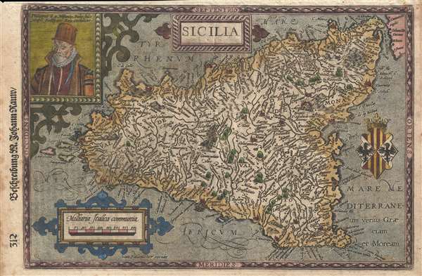
Sicilia.
1600 (undated) 8 x 12.5 in (20.32 x 31.75 cm) 1 : 1000000
1600 (undated) 8 x 12.5 in (20.32 x 31.75 cm) 1 : 1000000
Description
A rare 1600 map of Sicily, Italy, by Matthias Quad and Johann Bussemacher. There is an engraved portrait of Phillip II of Spain, who, among his other titles, was also King of Sicily. I the upper left corner. Published in Cologne. Quad's imprint appears as a 'Q' in the lower left corner. The map is richly detailed according to 16th century German conventions. Mount Etna, is prominently aflame. Villages and towns are rendered in profile. There is a baroque title cartouche top center and the royal crest of the Kingdom of Sicily, right center. Cartographically, this map is derived from the 1545 map of Sicily by Giacomo Gastaldi.
The distinctive style of this map is reflective of the Cologne school, which prospered in the late 16th and early 17th centuries. When Dutch and Flemish refugees, many well educated, fled religious persecution in the Netherlands, they set up shop in Cologne, turning it into one of Europe's great map publishing centers. The style is reminiscent of 16th century Dutch work, with stippled seas, baroque cartouches, and Latin content. Prominant cartographers of the Cologne school include Quad Matthaeus, Johannes Metellus, Giovanni Botero and Franz Hogenberg.
The map was engraved by Johann Bussemacher and published by Matthias Quad in Cologne. There are three editions, of which this is the second. It was published in the 1600 edition of Quad's Geographisch Handt-buch. An earlier edition dates to 1594, and a later edition was published in 1608. Cartographically all editions are identical.
CartographerS
Matthias Quad (1557 - October 29, 1613) was Dutch engraver active in Cologne during the late 16th and early 17th centuries. Quad was born in the Netherlands and studied engraving under Johannes van Deutecum (fl. 1552 - 1606) of Deventer and Hendrick Goltzius (1558-1616) of Haarlem. Around 1580 he relocated to Heidelberg or Cologne where he primarily engraved geographical texts in conjunction with fellow publisher Johann Bussemacher. In 1608 he published an atlas, Fasciculus Geographicus, with Bussemacher in Cologne. In 1609, another major work, his Teutscher Nation Herligkeit, a historico-cultural regional study of Germany, was published by Wilhelm Lutzenkirchen . More by this mapmaker...
Johann Bussemacher (fl. c. 1580 - 1613) was a German publisher, engraver, art dealer, and bookseller active in Cologne in the late 16th and early 17th centuries. He was trained as a copper engraver in Dusseldorf, where he was born. Around in 1583 he established his own imprint and a publishing concern in Cologne. Bussemacher was for a time the largest and most successful publisher in Cologne. He is commonly associated with producing engraved images of saints and noble personages, but he also issued several maps in conjunction with Matthias Quad. Learn More...
Source
Quad, M., Geographisch Handt-buch, (Cologne: Quad) 1600.
Condition
Very good. Some marginal soiling. Even toning.
References
OCLC 956310481.