1975 Japan Air Lines Bilingual Pictorial Tourist Map of Singapore
Singapore-jal-1975$1,200.00


Title
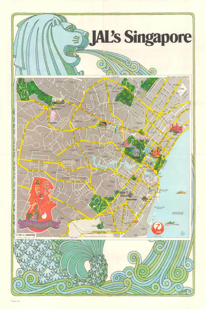
JAL's Singapore / Singapore / シンガポール.
1975 (dated) 20.75 x 14.25 in (52.705 x 36.195 cm) 1 : 17000
1975 (dated) 20.75 x 14.25 in (52.705 x 36.195 cm) 1 : 17000
Description
This is a scarce, unrecorded bilingual 1975 city plan of Singapore produced by Japan Air Lines. Designed for American tourists, it is an early manifestation of Singapore's emergence as a tourist destination in the 1970s and 1980s.
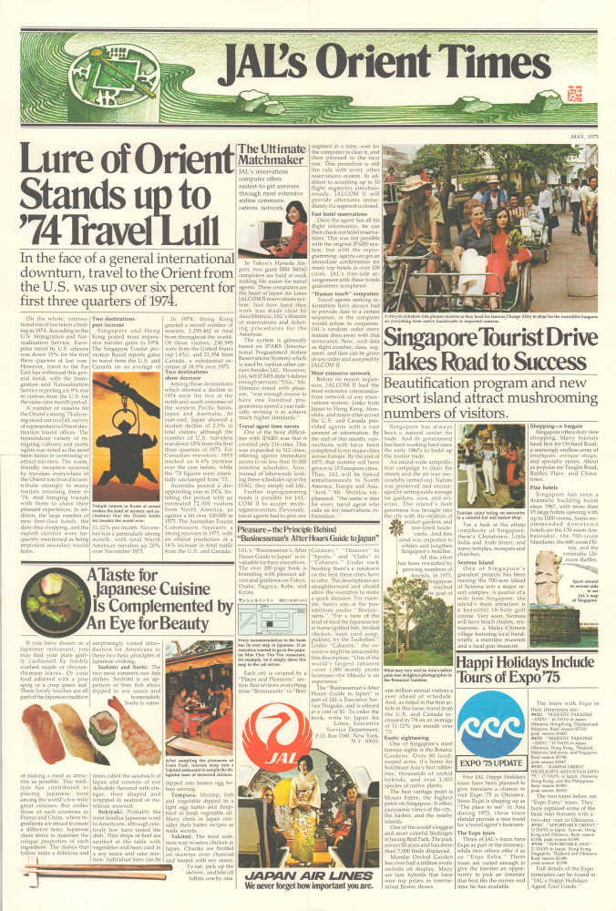
Promotional text and images on the verso are aimed at American business travelers, noting that travel to 'the Orient' managed to increase while overall international travel decreased significantly in the previous year (no doubt due to the 1973 oil crisis and related economic headwinds). Designed like the front page of a newspaper, 'articles' promote destinations in Japan, Okinawa (which hosted an international exposition in 1975), and Singapore. 'Beautification' efforts in Singapore are discussed at some length. At center-bottom is discussion of JAL's 'Businessman's After Hours Guide to Japan,' listing bars, clubs, and cabarets for every major city in Japan.
Still, the transformation of Singapore's economy between 1960 and the 1980s was remarkable, as Lee and his associates in the People's Action Party instituted a range of policies to calm domestic unrest and attract foreign investment, especially electronics manufacturers from the U.S. and Japan. At the same time, the state was heavily involved in cultivating heavy industry like steel and shipping. In doing so, Lee was borrowing from a model often called the 'developmental state' that was earlier pursued by Japan, contemporaneously by several other Asian nations, particularly South Korea, and since by mainland China.
A Closer Look
This map covers the most developed part of Singapore, including the old colonial city just north of the Singapore River. Streets are labeled throughout, sometimes with their names in Japanese as well as English. Hotels, parks, temples, mosques, churches, schools, the National Theater, the National Museum, China Town, the JAL Office, the National Tourism Promotion Board (N.T.P.B.) office, and other locations are noted throughout the city. Illustrations highlight the island's more urbane destinations, though seedier and more vulgar attractions are also delicately mentioned, such as the Thieves' Market (Flea Market) on Sungei Road, and the Great World and New World Amusement Parks, famous for boxing matches, wrestling, cabaret shows, and dancing. By the end of the decade, such venues were decreasing in popularity as Singaporeans turned to television and shopping malls, and the government sought to encourage more wholesome forms of entertainment (and weaken the organized crime outfits that were seen as profiting from such venues).Promotional text and images on the verso are aimed at American business travelers, noting that travel to 'the Orient' managed to increase while overall international travel decreased significantly in the previous year (no doubt due to the 1973 oil crisis and related economic headwinds). Designed like the front page of a newspaper, 'articles' promote destinations in Japan, Okinawa (which hosted an international exposition in 1975), and Singapore. 'Beautification' efforts in Singapore are discussed at some length. At center-bottom is discussion of JAL's 'Businessman's After Hours Guide to Japan,' listing bars, clubs, and cabarets for every major city in Japan.
Singapore's Economic Miracle
This map captures Singapore a mere decade after being expelled from Malaysia and establishing an independent but tenuous city-state republic. Surrounded by hostile powers and riven by ethnic strife, the country rapidly transitioned into a wealthy, modern economic powerhouse, or, 'from third world to first,' to borrow a phrase from Lee Kuan Yew (1923 - 2015), Singapore's Prime Minister throughout this era and arguably the main architect of this transition. Singapore's economic miracle benefited from a strong foundation of a population steeped in commercial activity and connected to a trading network running throughout the British Empire. The country also occupies an extremely advantageous strategic position.Still, the transformation of Singapore's economy between 1960 and the 1980s was remarkable, as Lee and his associates in the People's Action Party instituted a range of policies to calm domestic unrest and attract foreign investment, especially electronics manufacturers from the U.S. and Japan. At the same time, the state was heavily involved in cultivating heavy industry like steel and shipping. In doing so, Lee was borrowing from a model often called the 'developmental state' that was earlier pursued by Japan, contemporaneously by several other Asian nations, particularly South Korea, and since by mainland China.
Publication History and Census
This map was prepared by Japan Air Lines (now stylized as Japan Airlines) in May 1975. The art appearing above and below the map, depicting a Merlion, the mythic creature which is the symbol of Singapore, was drawn by American artist Raymond Ameijide. We have been unable to locate any other examples of this map in institutional collections or on the market. The Library of Congress holds what may be a later edition, dated 1979 (OCLC 54096223).Cartographer
Raymond Joseph Ameijide (September 14, 1924 - January 11, 2000) was an American artist and graphic designer. Born in Newark, New Jersey, he earned a bachelor's in fine arts from the Pratt Institute before serving in the U.S. Army during the Second World War. After the war, he became a graphic designer and multimedia commercial artist, and also married Irene Kipus, with whom he had four children. Ameijide illustrated for major publications like Fortune and National Geographic, as well as companies including TV Guide, IBM, and Pfizer. Ameijide won several prestigious awards throughout his career, in particular from the Society of Illustrators. But he was perhaps best known for his paper bas-relief and felt three-dimensional creations that were often featured in advertisements for his clients, particularly a series of caricatures of actors and television stars for TV Guide. More by this mapmaker...
Condition
Very good. Slight wear on old fold lines.