This item has been sold, but you can get on the Waitlist to be notified if another example becomes available, or purchase a digital scan.
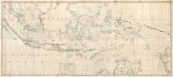
1856 Charles Wilson Nautical Map of the East Indies: Singapore to Australia
SingaporeEastIndies-wilson-1856$2,500.00

Title
The Lower Part of the China Sea.
1856 (dated) 33 x 73 in (83.82 x 185.42 cm) 1 : 2850000
1856 (dated) 33 x 73 in (83.82 x 185.42 cm) 1 : 2850000
Description
An extremely rare large format 1856 Charles Wilson nautical chart or maritime map covering most of the East Indies from Singapore, Malaya, and Sumatra to New Guinea and Cape York Peninsula (Queensland, Australia). And from Northern Borneo to northern Australia. It exhibits superb detail and offers copious soundings, trade routes, and annotations of value to the mariner. A few pencil annotations reflect actual shipboard use. Inset submaps detail Kings Cove on Melville Island, Port Cockburn, and Cyrus Harbour. Here an there annotations describe regions as 'very little known' or 'unexplored'.
This map was first published in 1855 with the present example being the second edition, dating 1856. It was issued by Charles Wilson, inheritor of J. W. Norie's Navigation Warehouse and Naval Academy. This is the only known example of this chart.
This map was first published in 1855 with the present example being the second edition, dating 1856. It was issued by Charles Wilson, inheritor of J. W. Norie's Navigation Warehouse and Naval Academy. This is the only known example of this chart.
Cartographer
Charles Wilson (1807 - May 16, 1882) was a British-Indian publisher of nautical charts and maps based in London, England. Born in Lucknow, India, Wilson was the son Lieutenant-Colonel William Wilson and his wife Hoosainee Begum, an Indian princess, who was the daughter of the Nizam of Ashrafabad. Wilson was educated in England and worked in the wine trade before joining the Norie firm in 1838. Norie had already partnered with another Wilson, George, who was a nephew to Charles. When Norie retired in 1840, Charles Wilson took over the firm publishing as 'Charles Wilson (Late J.W. Noire and Wilson)'. He married Jane Arabella Bingle on July 1, 1846. Wilson died in 1882 passing the firm on to his sons, George and William Wilson. The brothers merged the firm with that of J. Imray and Sons in 1899 and, as Imray, Laurie, Norie and Wilson Ltd., they continue to publish to the present day. More by this mapmaker...
Condition
Very good. Professionally restored.